
Lauko geležinkeliai


Plačiai paplitusių 600 mm vėžės geležinkelių statyba siejama su Pirmojo pasaulinio karo pradžia, kai Vokietijos armija 1916 m. okupuotoje Latvijos teritorijoje pradėjo tiesti kelis vadinamuosius „karo lauko“ (vok. „Heeresfeldbahn“) geležinkelius.
Atsižvelgiant į prastas kelių sąlygas tuo metu, surenkamasis geležinkelis buvo tinkamiausia fronto aprūpinimo karo lauke priemonė. Vokietijos armija turėjo specialius dalinius, kurie specializavosi „lauko“ geležinkelių statyboje ir eksploatavime. Specialiai armijai suprojektuota „karo lauko“ geležinkelių įranga, tokia kaip bėgiai, vagonai ir lokomotyvai, buvo standartizuota, o tai supaprastino šių geležinkelių eksploatavimą.
Priekyje buvo pristatytos surinktos tiesios ir lenktos bėgių atkarpos, 5 metrų ilgio ant 10 geležinių pabėgių, kurios, esant geroms oro sąlygoms, leido per vieną dieną nutiesti kelis kilometrus „karo lauko“ geležinkelio. Šie geležinkeliai galėjo būti pastatyti greitai arba nugriauti ir transportuoti į kitą fronto liniją.
Austrijos, JAV, Prancūzijos ir Didžiosios Britanijos armijos taip pat turėjo panašius dalinius ir standartizuotą įrangą karo meto lauko geležinkeliams.
Daugiau informacijos šaltinių
Istorija – Ventspilio muziejus
Geležinkelio objektai – Ventspilio muziejus
geležinkelių transportas Latvijoje – Nacionalinė enciklopedija (enciklopedija.lv)
Susijusi laiko juosta
Susijusios vietos
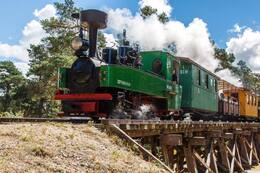
Ventspilio Pajūrio muziejaus po atviru dangumi geležinkelis (Mazbanytis)
Ventspilio Pajūrio muziejuje po atviru dangumi galite pasivažinėti dviem siaurojo geležinkelio linijomis su traukinuku „Mazbānītis“. Žiedinė linija yra 1,4 km, o kalnų linija – 3 km. „Mazbānītis“ – tai lokomotyvas, kuris 1916–1963 m. 600 mm siaurojo geležinkelio bėgiais vežė keleivius ir krovinius. Tai Pirmojo pasaulinio karo karinės istorijos palikimas, kuris kadaise atliko svarbų vaidmenį šiaurinės Kuržemės kultūriniame ir ekonominiame vystymesi, jungdamas gyvenvietes ir suteikdamas naujų darbo vietų.
Didelio 600 mm siaurojo geležinkelio tinklo statyba daugiausia siejama su Pirmuoju pasauliniu karu, kai 1916 m. Vokietijos armija okupuotoje Latvijos teritorijoje pradėjo kelių vadinamųjų karinių lauko geležinkelių (vok. Heeresfeldbahn) statybą. Šie geležinkeliai galėjo būti greitai nutiesti, išardyti ir perkelti į kitą fronto liniją. Latvijos siaurojo geležinkelio tinklas buvo naudojamas ir Antrojo pasaulinio karo metu. Beveik 60 metų siaurasis geležinkelis buvo vienintelė saugi priemonė keleiviams, įvairiems žemės ūkio produktams ir medienai gabenti į miestus tiek žiemą, tiek vasarą.
Buvusi siaurojo geležinkelio atšaka Pirmojo pasaulinio karo metais: „Banhoff – Bhf. Waldl. Salit“ vieta
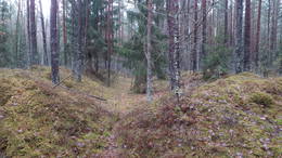
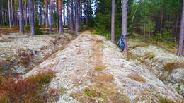
Į pietus ir šiaurę nuo Baldonės–Tomės kelio, V4 (Pirmojo pasaulinio karo žemėlapyje vadinamo „Düna Straße“), Pirmojo pasaulinio karo metu buvo įrengta siaurojo geležinkelio sistema, skirta fronto poreikiams tenkinti. Į pietus nuo minėto kelio buvo „Bhf. (Bahnhoff) Waldl. (Waldlager – „Miško stovykla arba sandėliai“) Salit“ – stotis „Miško stovykla/sandėliai?“. Geležinkelio linijos vietą galima atsekti tiek skirtingų laikų ir mastelių žemėlapiuose, tiek LIDAR žemėlapiuose, tiek gamtoje. Minėta geležinkelio atkarpa atsišakoja nuo šiuolaikinės Vecumniekų stoties (Bhf. Neugut Kurland) – Mercendarbės (Merzendorf) plačiojo geležinkelio maždaug už kilometro į rytus nuo Gēdiņu namų (stotis – „Bahnhoff Gedeng“). Pirmasis geležinkelio linijos kilometras nuo Gēdiņu stoties šiandien apaugęs mišku, o norint rasti linijos vietą gamtoje, reikia pasiimti LIDAR žemėlapius ir kantrybės, bristi apaugusiu, bet vis dar matomu geležinkelio pylimu. Abiejose geležinkelio linijos pusėse, prie greta esančio kelio ir kopos pylime (į pietus nuo kelio), gamtoje matomos mažiausiai 20 gilių, stačiakampių duobių (sandėlių?). Toliau... 1,3 km geležinkelio liniją gamtoje galima atsekti kaip gražų, skaidrų miško kelią, kuris vietomis kerta nedidelius kopų pylimus su juose išraižomis. Toliau – 3,5 km geležinkelio linija sutampa su Latvijos valstybinių miškų nutiestu keliu, kuris, staigiai pasukęs į šiaurės vakarus, geležinkelio linija toliau juda šiaurės rytų kryptimi ir po 0,3 km pasiekia buvusios stoties (Bhf. Waldl. Salit) vietą, kuri aiškiai matoma LIDAR žemėlapyje. Iš stoties gamtoje nieko neišliko, tačiau apylinkėse matyti daug įvairaus gylio ir formos iškastų duobių, o kopų pylimuose, juosiančiuose stoties vietą, – apkasų liekanos. Prieš minėtą stotį matoma kopų iškasa, kur geležinkelio linija tęsiasi šiaurės kryptimi. Ties Silių namais ji kirto Silupius (Kausupi) (buvusi stotis „Bhf. Sille“), tačiau ties Podniekių namais ji atsišakoja. Pirmoji atšaka pasuko dešinėn į Berkavą, antroji – kairėn į Vilkų kalnus ir grįžo prie plačiojo geležinkelio (1435 mm) Skarbės stotyje.
Ķeizerdambis (Kaiser-Damm)
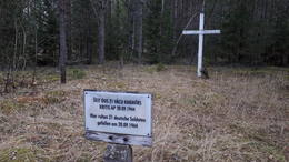
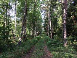
Pirmojo pasaulinio karo Vokietijos armijos žemėlapiuose buvo pažymėtas maždaug 8 km ilgio kelias šiuo pavadinimu, prasidedantis nuo buvusio Kurlando paminklo (Kurland Denkmal), vėliau populiariai vadinamo Mātīte paminklu, ir pasibaigiantis prie buvusio Auermanno namo (Auermann). Šiandien Ķeizerdambis, orientuotas šiaurės rytų-pietvakarių kryptimi, per visą jo ilgį gali būti vaikščiojamas arba važiuojamas dviračiu. Jis driekiasi apie 4 km kaip miško-žemės (vietomis su stambiais žvyro gabalėliais) kelias ir 4 km kaip žvyrkelis (sutampantis su Latvijos valstybinių miškų nutiestais Abermaņas ir Egle-Kaulupe keliais). Ruožas tarp Elge-Kaulupe kelio ir Abermaņas kelio LVM žemėlapiuose dar vadinamas Mātīte taku. Vidurinėje atkarpoje Ķeizerdambis kerta gražų sausumos kopų masyvą, kurio apylinkėse LIDAR žemėlapiuose matomi karo laikų apkasai ir statybvietės. Prie buvusio Aurmanio namo, toje vietoje, kur palaidoti 21 vokiečių armijos kareiviai (žuvę apie 1944 m. rugsėjo 20 d.), pastatytas baltas medinis kryžius.
Gali būti, kad Kaiserdamm pavadinimas, atsiradęs, kai Pirmojo pasaulinio karo metu čia buvo dislokuota vokiečių kariuomenė, kilęs iš Kaiserdamm – 50 m pločio ir 1680 m ilgio gatvės Berlyne, atidarytos 1906 m.
Buvusių Pirmojo pasaulinio karo kareivinių vieta
Įsikūręs miške 0,6–0,7 km į pietus nuo Latgalos kaimo. Geriausias vaizdas apie teritoriją susidaro, jei ji ištirta LIDAR žemėlapiuose, nes gamtoje prieš šimtmetį žmonių iškastų tranšėjų ir kitų žemės paviršiaus darinių padėtis gali likti nepastebėta nepažįstančiajam. Sprendžiant iš plytinės liekanų ir kitų kasinėjimuose (atliktuose kažkieno kito) matomų ženklų, čia buvo vokiečių armijos kareivinės. Šalia kareivinių palei Didžiąją Kurfirst užtvanką nuo šiuolaikinės Lāčplēsio stoties palei Birzgalius ir toliau iki Dauguvos fronto linijos aprūpinimo buvo nutiestas siaurasis geležinkelis. 0,5 km į rytus nuo kareivinių buvo vadinamasis Kurlando arba Mātītės paminklas (Kurland Denkmal), tačiau kairiajame Dauguvos krante, 1,3 km spinduliu aplink kareivines, buvo pastatyti trys gelžbetoniniai ugnies punktai (išlikę iki šių dienų, tačiau vieno liekanos yra po vandeniu ir atsiranda tik sumažinus HE vandens lygį), o 0,6 km į vakarus nuo jų buvo šaudykla, kurios gamtoje nieko neišliko. Aplink šaudyklą gamtoje matomos duobės – buvusių pastatų ir įtvirtinimų liekanos. Maždaug 100–200 m į pietryčius nuo buvusių kareivinių vietos gamtoje aiškiai matomi trys–30 m ilgio stačiakampiai apkasai (ir mažesni), kurie galėjo būti sandėliai.
Siaurojo geležinkelio linija I pasaulinio karo metais: Lāčplēsis – Latgala
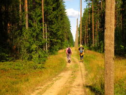
Maždaug 22 km ilgio Pirmojo pasaulinio karo siaurojo geležinkelio linija, prasidėjusi dabartinėje Lāčplēsio (Jelgavos–Krustpilio geležinkelio linijos) geležinkelio stotyje (buvusi Bahnhoff Kerghof), iš rytų apjojo Birzgalius, kirto Žegos upę, tada pasuko į vakarus, du kartus kirsdama šiuolaikinį Abermaņa kelią (jungiantį Ķegumą su Vecumniekų (P88) keliu) ir toliau palei Ķeizardambi (Kaiser–Damm) iki buvusio Kuršo paminklo (Kurland Denkmal), kur, sprendžiant iš matomo LIDAR žemėlapio (padalinto į tris atšakas?), buvo galutinė stotis. Kuršo paminklas buvo 680 m į pietryčius nuo Latgalės kaimo. Pagrindinė geležinkelio paskirtis buvo aprūpinti ir paremti frontą kairiajame Dauguvos krante reikalingu turtu. Pirmojo pasaulinio karo metu netoli Ķeizerdambo buvo vokiečių armijos kareivinės ir sandėliai, o kairiajame Dauguvos krante ties Puduriais (0,6 km) ir Podniekiais (0,9 km) buvo trys vokiečių armijos betoniniai ugnies punktai. Šiandien geležinkelio linijos vietą galima atsekti naudojant LIDAR žemėlapius gamtoje. Kai kurios jos dalys taip pat aiškiai matomos gamtoje, ypač kai augmenija dar nesuaugusi. Geriausias laikas leistis į ekspediciją yra ankstyvas pavasaris arba žiema, kai nėra sniego.
Princo Leopoldo kelias (Prinz – Leopold Straße)
Pirmojo pasaulinio karo vietos (kelio) pavadinimas yra „Prinz – Leopold Straße“ – Kunigaikščio Leopoldo kelias. Istorinis miško kelias arba jo vieta, apie 7 km ilgio, prasidėjo Didžiojo Kurfürsten Damm ir Kaiser Damm sankryžoje prie vadinamojo Kurlando paminklo (Kurland Denkmal) ir vingiuoja per mišką Birzgalės link, susijungdamas su Pirmojo pasaulinio karo siaurojo geležinkelio linija: Lāčplēsis – Latgale. Į vakarus nuo kelio ir apie 2 km į pietus nuo Kurlando paminklo (Kurland Denkmal) yra Pirmojo pasaulinio karo šaudykla. Šiandien Kunigaikščio Leopoldo keliu galima vaikščioti pėsčiomis, važiuoti dviračiu ir automobiliu (tinkamomis sąlygomis). Kelias kerta Konupītę ir Žegos intaką.
Manoma, kad vokiečių armijos kareiviai, ilgą laiką praleidę kairiajame Dauguvos upės krante, šį kelią pavadino Bavarijos princo Leopoldo (1846–1930), kuris Pirmojo pasaulinio karo metu vadovavo Vokietijos ir Austrijos-Vengrijos pajėgoms Rytų fronte, vardu.
Siaurojo geležinkelio linija I pasaulinio karo metais: Lāčplēsis – Vitkopi
Apie 9 km ilgio geležinkelio linijos, prasidėjusios dabartinėje Lāčplēsio geležinkelio stotyje (Bhf. Kerghof) ir pasibaigusios dabartiniame Witkopu ežere (Bhf. Witkop), vieta. Linijoje buvo dar dvi stotys: Bhf. Sillesemnek (Silenieki) ir Bhf. Hasenheide. Gamtoje ir LIDAR žemėlapyje, į šiaurę nuo Witkopo ežero (dirbtinai sukurto rezervuaro), matoma > 100 įvairaus dydžio ir formos duobių – spėjama, kad tai Pirmojo pasaulinio karo laikų pastatų, sandėlių ir kt. infrastruktūros „pėdsakai“. Į pietus nuo ežero yra Witkopų brolių kapinės. Šios geležinkelio linijos dėka Pirmojo pasaulinio karo metu buvo užtikrinti vokiečių armijos fronto kairiajame Dauguvos krante poreikiai.
Taurkalnės vokiečių armijos sandėlio aikštelė
Maždaug 0,7 x 0,4 km dydžio miškinga teritorija į šiaurę nuo Jelgavos–Krustpilio geležinkelio ir į rytus nuo Taurkalnės kaimo, kurią kerta miško kelias ir takai. Gamtoje ir LIDAR žemėlapiuose matyti apie 100 stačiakampių duobių, iškastų tiesiomis eilėmis su mažais pylimais ir išėjimu. Pasak Daumanto Krastinio: „Vokiečių sandėliai iš dalies užkasti žemėje. Antstatas dengtas mediniu arba gofruotu skardos stogu. Čia ilgesni sandėliai su įėjimais abiejuose galuose buvo personalo kareivinės. Netoliese yra Pirmojo pasaulinio karo laikų įprasta ir kaimo geležinkelio stotis, tačiau Antrojo pasaulinio karo metu antstatas galėjo būti restauruotas ir panaudotas „Nord“ grupės aprūpinimui, naudojant netoliese esantį Dauguvos tiltą. Jei Antrojo pasaulinio karo metu buvo laikoma amunicija, tai ja spėjo naudotis iki desanto iš oro 1944 m. rugsėjo 19 arba 20 d.“ Išliko vietos gyventojų pasakojimų apie vokiečių armijos požemines perėjas ir iškastą bunkerį vienoje iš vietovės kalvų, taip pat apie vokiečių traukinį, kuris „įvažiavo po žeme po kalnu“.

Buvęs I pasaulinio karo laikų geležinkelis: Vecumnieki – Mercendarbe
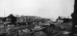
1916 m., kai Vokietijos armijos fronto linija kairiajame Dauguvos krante sustiprėjo ir stabilizavosi, kovo 15 d. buvo nuspręsta fronto aprūpinimo reikmėms nutiesti 25 km ilgio geležinkelio liniją su 1435 mm vėžės pločiu nuo Vecumniekių (Bhf. Neugut Kurland) iki Baldonės (stotis: Mercendarbė - Merzendorfas). Kovo 30 d. darbus pradėjo apie 5000 darbininkų, o iki gegužės 1 d. linija buvo nutiesta iki Skarbės stoties, o gegužės 6 d. – iki Mercendarbės. Stočių eilė iš pietų į šiaurę buvo tokia: Neugut Kurland, Nougut Nord, Birsemnekas, Gedengas, Skarbė, Merzendorfas. Kroviniai buvo perkraunami didžiausioje iš stočių – Skarbėje, iš kur jie į frontą buvo gabenami arklių traukiamu transportu. Dar 1921 m. geležinkelio linija buvo gabenami rąstai ir malkos, kol 1925 m. ji buvo nugriauta. Geležinkelio linijos vieta skirtinguose ruožuose labai skiriasi – vietomis ją kerta įvairios svarbos keliai, vietomis ji kerta miško masyvus kaip aiškiai matomas pylimas. Yra vietų, kurias vegetacijos laikotarpiu sunku pravažiuoti.
Ties buvusia Gedinių stotimi („Bahnhoff Gedeng“) šiaurės rytų kryptimi atsišakoja siaurasis geležinkelis, kurio bėgiai tęsiasi Dauguvos link. Ties Silo namais jis kirto Silupius (Kausupi) (buvusi stotis „Bhf. Sille“), bet ties Podniekių namais atsišakoja. Pirmoji atšaka pasuko į dešinę į Berkavą, antroji – į kairę į Vilkų kalnus ir tada Skarbės stotyje grįžo į plačiąjį (1435 mm) geležinkelį.
1917 m. rugsėjį vokiečiai nutiesė dar vieną siaurojo geležinkelio liniją (600 mm pločio) nuo Mercendarbės ir Skarbės iki Dauguvos, kur pastatė pontoninį tiltą ir spalio 1 d. atidarė eismą iki pat Ikškilės. Gruodžio 4 d. potvynis nunešė minėtą tiltą.
Mazbānīčio takas Šiaurės Kuržemėje
Mažbānīte Šiaurės Kuržemėje vadinamas traukinys, kuris 1916–1963 m. 600 mm pločio siaurojo geležinkelio bėgiais vežė keleivius ir krovinius. Tai Pirmojo pasaulinio karo laikų karinės istorijos palikimas, kuris kadaise atliko svarbų vaidmenį visos Šiaurės Kuržems, o ypač Lyvių žvejų kaimų, kultūriniam ir ekonominiam klestėjimui, užtikrindamas susisiekimą tarp gyvenviečių ir suteikdamas darbo vietų.
Gamtos takas veda iš Mazirbės į Sīkragą buvusiu Stendės–Ventspilio siaurojo geležinkelio keliu, arba, kaip sako vietiniai – mazbānīšos keliu. Geležinkelio tiesimas pradėtas 1916 m. ir veikė iki 1963 m. Siaurojo geležinkelio linija jungė Ventspilio uostamiestį su pakrantės žvejų kaimais, Dundagu ir dideliu geležinkelio mazgu Stendėje, taip prisidėdama prie regiono ekonominio ir kultūrinio klestėjimo tarpukariu.
Sovietų Sąjungos laikais pakrantė buvo „Uždara zona“, todėl pakrantės kaimai buvo ekonomiškai izoliuoti, o jų gyventojų skaičius mažėjo. Naujai pastatytų slaptų karinių objektų buvimas taip pat prisidėjo prie to, kad septintajame dešimtmetyje buvo sustabdytas geležinkelių eismas.
Takas turi trumpą 15 km ilgio žiedą ir ilgą 19 km ilgio žiedą.
GPX žemėlapis pasiekiamas čia:
https://www.kurzemesregions.lv/projekti/turisms/unigreen/dabas-takas/mazbanisa-dabas-taka/
Stendės geležinkelio stotis siaurojo geležinkelio tinkle ir atminimo akmuo tremtims
Geležinkelio linija Ventspilis–Mazirbė, taip pat Stendės–Dundagos pratęsimas iki Mazirbės su atšaka iki Pitragės buvo skirti tik strateginėms karinėms reikmėms. Šių linijų statybos metu ir vėliau iš regiono buvo evakuoti visi civiliai gyventojai. Pagrindinė karinių geležinkelių užduotis Irbės sąsiaurio rajone buvo aprūpinti Vokietijos armijos pakrantės gynybos pozicijas pabūklais ir amunicija.
Šie tik kariniams tikslams skirti kariniai geležinkeliai taip pat sujungė tris svarbiausius švyturius, esančius Ovišuose, Mikeltornyje ir Šlīterėje.
Nepaisant to, keleivių pervežimas buvo vykdomas jau Pirmojo pasaulinio karo metais.
Stendės geležinkelio stotyje yra atminimo akmuo (1989 m.) 1941 ir 1949 m. deportuotiems latviams.
1919 m. spalio 30 d. Stendės geležinkelio stotį užėmė Bermonto kariuomenė. Lapkričio 17 d. Latvijos armijos kareiviai, vadovaujami K. Šnēbergo, puolė stotį, nuvarydami vežimą su ginklais, karo medžiagomis ir grūdais. Už šiuos mūšius ordino ordinu buvo apdovanoti 6 kareiviai: K. Bumovskis (1891–1976), P. Strautiņš (1883–1969), R. Plotnieks (1891–1965), E. Jansons (1894–1977).
Viesytės muziejus „Sėlija“ (Sēlija)
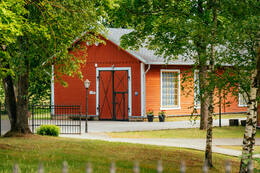
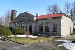
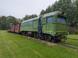
Viesytės muziejų sudaro keli skyriai: Sėlijos namai, kuriuose įrengta Sėlijos kultūros istorijos ekspozicija, Turizmo informacijos punktas, veikiantis buvusiame geležinkelio kontoros pastate, buvusi Viesytės depo lokomotyvų remonto dirbtuvė, Amatų centras ir Sėlijos siaurojo geležinkelio istorijos ekspozicija, įrengta buvusioje geležinkelio vagonų remonto dirbtuvėje. Žinomiausia Viesytės muziejaus dalis – Mažojo Traukinuko parkas, įkurtas buvusio Viesytės geležinkelio depo teritorijoje.
Siaurąjį geležinkelį, iš pradžių skirtą kariniams kroviniams vežti, 1915–1916 m. nutiesė vokiečių kariuomenė, tačiau po Pirmojo pasaulinio karo jis buvo pritaikytas keleivių pervežimams. Muziejuje galima pamatyti 1918 m. bendrovės „Schwarzkopff“ pagamintą garvežį, 1916 m. pagamintą tarnybinį vagoną, krovininį vagoną, medienos transportavimo platformą, vagonėlį, dreziną ir susipažinti su Sėlijos siaurojo geležinkelio istorija. Muziejui taip pat priklauso septyni istoriniai stoties pastatai. Mažojo Traukinuko parke laukiami lankytojai su vaikais.
Netoli nuo minėto parko, istorinėje Viesytės stoties aikštėje yra išlikusi vienintelė Latvijoje siaurojo geležinkelio atkarpa su senoviniu vandens siurbliu. Prie stoties aikštės stovi keli istoriniai pastatai: geležinkelio krovinių sandėlis, kultūros namai, keleivių stoties pastatas ir ambulatorija.
Vecumniekų geležinkelio stotis
Vecumniekų geležinkelio stotis yra į pietus nuo Vecumniekų kaimo.
Vecumniekų geležinkelio stotis buvo pastatyta 1904 m. kaip stotis Ventspilio–Maskvos geležinkelio linijoje. Iš pradžių ji vadinosi „Neugut“ (vokiečių okupacijos metu 1916/1917 m. ji buvo vadinama „Neugut Kurland“). Didesnę reikšmę ji įgijo Pirmojo pasaulinio karo metu, kai iš jos buvo nutiesta europinio masto geležinkelio atšaka. 1916 m., kai Vokietijos armijos fronto linija kairiajame Dauguvos krante sustiprėjo ir stabilizavosi, kovo 15 d. buvo nuspręsta fronto aprūpinimo reikmėms nutiesti 25 km ilgio geležinkelio liniją su 1435 mm vėžės pločiu nuo Vecumniekų iki Baldonės (stotis: Mercendarbė – Merzendorfas). Kovo 30 d. darbus pradėjo apie 5000 darbininkų, o iki gegužės 1 d. linija buvo nutiesta iki Skarbės stoties, o iki gegužės 6 d. – iki Mercendarbės. Stočių eilė iš pietų į šiaurę buvo tokia: Neugut Kurland, Nougut Nord, Birsemnek, Gedeng, Skarbe, Merzendorf. Didžiausioje iš stočių – Skarbėje – kroviniai buvo perkraunami, iš kur arklių traukiamu transportu buvo gabenami į frontą. Šis geležinkelis egzistavo tik kelerius metus, dar 1921 m. geležinkelio linija buvo gabenami rąstai ir malkos, kol ji buvo nugriauta 1925 m. Geležinkelio linijos vieta skirtinguose ruožuose labai skirtinga – vietomis ją kerta įvairios svarbos keliai, vietomis, kadangi aiškiai matomas pylimas, ji kerta miško masyvus. Yra vietų, kurias vegetacijos laikotarpiu sunku pravažiuoti.
Ties buvusia Gedinių stotimi („Bahnhoff Gedeng“) šiaurės rytų kryptimi atsišakoja siaurasis geležinkelis, kurio keliai tęsiasi Dauguvos link. Ties Silo namais jis kirto Silupius (Kausupi) (buvusi stotis „Bhf. Sille“), bet ties Podniekių namais atsišakoja. Pirmoji atšaka pasuko į dešinę į Berkavą, antroji – į kairę į Vilkų kalnus ir Skarbės stotyje grįžo į plačiąjį (1435 mm) geležinkelį.
1917 m. rugsėjį vokiečiai nutiesė dar vieną siaurojo geležinkelio liniją (600 mm pločio) nuo Mercendarbės ir Skarbės iki Dauguvos, kur pastatė pontoninį tiltą ir spalio 1 d. atidarė eismą iki pat Ikškilės. Gruodžio 4 d. potvynis nuplovė minėtą tiltą.
Nuo 1919 m. stotis vadinama Vecmuiža. 1926 m. karo metu sunaikinto medinio stoties pastato vietoje buvo pastatytas mūrinis pastatas (architektas J. Neijs). 1940 m. stotis buvo pervadinta į Vecumnieki. 1941 m. birželio 14 d. ir 1949 m. kovo 25 d. iš Vecumnieki stoties, taip pat iš daugelio kitų Latvijos geležinkelio stočių, buvo deportuoti keli šimtai Latvijos gyventojų. Iš viso dėl 1949 m. kovo 25 d. (iki kovo 30 d.) vykdytų deportacijų nukentėjo 44 271 Latvijos gyventojas.
2000 m. keleivinių traukinių eismas Jelgavos–Krustpilio linijoje buvo uždarytas; šiuo metu ši linija naudojama tik krovininių traukinių eismui.
Siaurasis geležinkelis Biržuose
XX a. siaurojo geležinkelio kompleksas, turintis didelę istorinę, architektūrinę ir vaizdinę vertę.
„Siaurukas“ – tai 750 mm (2 pėdos 5 1/2 colio) pločio siaurasis geležinkelis, ilgiausias Europoje ir vienas unikaliausių paveldo objektų Lietuvoje, todėl išlikusios siaurojo geležinkelio atkarpos yra saugomos kaip kultūros vertybė. Lietuvoje yra 158,8 km (110 mylių) 750 mm (2 pėdos 5 1/2 colio) pločio siaurojo geležinkelio linijų, nors reguliariai naudojama tik 68,4 km (aptarnaujančių penkias stotis), kuriose veikia 12 lokomotyvų. Jos įtrauktos į Lietuvos nekilnojamojo kultūros paveldo objektų registrą.
Siaurojo geležinkelio linija Biržus pasiekė 1921–1922 m., kai buvo pratęstas Biržų–Gubernijos geležinkelio ruožas. Tai buvo pirmasis siaurojo geležinkelio ruožas, nutiestas pačios Lietuvos valstybės lėšomis.
Nepriklausomos Lietuvos metais buvo nutiestas 467 km siaurojo geležinkelio. Juo buvo gabenamos eksportuojamos miško medžiagos, kvarcinis smėlis, gyvuliai, linai, burokėliai, maisto atsargos. Traukiniais suaugusieji važiuodavo į darbą, o vaikai – į mokyklą. Savaitgaliais traukinys būdavo pilnas uogautojų ir grybautojų, o žiemą – slidininkų. Iki Gubernijos linijos galinės stoties Šiaulių mieste traukinys sustodavo 16 geležinkelio stočių.
1922 metais keleivis už vieną nuvažiuotą kilometrą pirmos klasės vagone turėjo mokėti 7,20 angliško auksino (vokiečių ostmarkių), o už trečios klasės vagoną – 1,80 angliško auksino.
Antrojo pasaulinio karo metu siaurasis geležinkelis buvo militarizuotas. Juo taip pat paprastais gyvuliniais vagonais buvo gabenami „valstybės priešai“ – asmenys, kuriuos sovietų valdžia laikė nelojaliais (net ir be jokios ypatingos priežasties) – priverstinei deportacijai į Sibirą. Po karo siaurojo geležinkelio atkūrimo ir plėtros perspektyvos tapo labai neaiškios. Lietuvos geležinkelio ateitį lėmė sovietinės ekonomikos ir politikos tikslai.
Nuo 1945 iki 1980 metų buvo uždaryta daugiau nei 400 km iš 20 siaurojo geležinkelio ruožų. Ilgiausi išliko Biržų - Joniškelių ir Joniškelių - Panevėžio ruožai, kuriuose krovinių apyvarta buvo šiek tiek didesnė. Į Biržus atvyko 3 traukiniai: 2 krovininiai ir 1 keleivinis. Plečiantis ir vystantis kelių transportui, siaurasis geležinkelis tapo ekonomiškai nestabilus. 1988 metais keleivių vežimas buvo nutrauktas. 1996 metais, Nepriklausomos Lietuvos Respublikos laikais, siaurojo geležinkelio linija į Biržus buvo visiškai uždaryta.
Šiandien siaurojo geležinkelio kompleksą sudaro depo ir stoties pastatai, vandens bokštas ir senoji geležinkelio atkarpa. Vėliau, kaip šlovingų dienų liudijimas, apžiūrėti buvo atvežtas neseniai perdažytas lokomotyvas.
Aukštaitijos baržų geležinkelis
Aukštaitijos siaurasis geležinkelis – 68,4 km (42,5 mylios) ilgio turistinis geležinkelis Lietuvoje, einantis nuo Panevėžio iki Rubikių, 750 mm vėžės pločio (2 pėdos 5+1⁄2 colio).
Siaurojo geležinkelio tiesimas pradėtas 1891 m., o jo vėžės plotis siekė 750 mm (2 pėdos 5 + 1⁄2 colio). Pirmoji atkarpa nuo Švenčionėlių iki Pastovi buvo baigta 1895 m. lapkričio 11 d., o 1898 m. ji buvo pratęsta iki Panevėžio. Reguliarus keleivių ir krovinių eismas prasidėjo 1899 m. rudenį. Iš pradžių geležinkeliu buvo 2 depai, 14 stočių, 15 lokomotyvų, 58 įvairių tipų keleiviniai vagonai, 6 pašto vagonai, taip pat 112 uždarų ir 154 atvirų krovininių vagonų. 1903 m. buvo pervežta apie 65 000 tonų krovinių ir 40 632 keleiviai.
Panevėžys tapo regioniniu centru Lietuvos nepriklausomybės laikotarpiu (1920–1938 m.), todėl buvo gabenama daug žaliavų, tokių kaip anglis, nafta, smėlis, druska ir trąšos, taip pat žemės ūkio produktai, tokie kaip linai, taukai, cukrus, grūdai, miltai ir mediena.
Pirmojo pasaulinio karo metu Vokietijos armija 1916 m. nutiesė du lauko geležinkelio pratęsimus su 600 mm (1 pėda 11 + 5⁄8 colio) vėže – nuo Gubernijos iki Pasvalijos ir nuo Joniškio iki Žeimelių. Geležinkelis buvo funkciniu požiūriu svarbus tarp Pirmojo ir Antrojo pasaulinių karų ir prisidėjo prie regiono ekonominio vystymosi. Po Antrojo pasaulinio karo jį eksploatavo valstybinė bendrovė „LRĮB „LRĮB „Geležinkeliai“.
XX a. antroje pusėje eismas pradėjo mažėti. 1996 m. buvo uždaryta geležinkelio linija į šiaurę nuo Panevėžio. Tais pačiais metais siaurasis geležinkelis buvo įtrauktas į Lietuvos Respublikos nekilnojamųjų kultūros vertybių sąrašą ir įgijo kultūros paveldo objekto statusą. Tuomet pradėjo kursuoti turistiniai traukiniai. Krovininis eismas palaipsniui nutrauktas 1999 m. 1999 m. lapkričio 1 d. valstybinėje geležinkelių bendrovėje „LRG“ buvo įsteigtas naujas Siaurojo geležinkelio departamentas. Tačiau keleivių eismas buvo laikinai sustabdytas 2001 m. Nuo 2006 m. turistinius traukinius traukia TU2 dyzeliniai lokomotyvai, kurie sulaukia didelio keleivių skaičiaus.
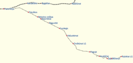
Daugeva – Sunākstes – Viesītes siaurasis geležinkelis
Viesytės siaurojo geležinkelio mazgas – strategiškai svarbus geležinkelių tinklas Sėlijoje
Viesytės siaurojo geležinkelio mazgas buvo didžiausias tokio pobūdžio geležinkelių tinklas (600 mm vėžė) Latvijoje. Jis veikė nuo 1916 iki 1972 m. ir sujungė kelis svarbius Sėlijos miestus ir kaimus – Neretą, Viesytės, Daudzevu, Jekabpilio, Aknīsčio ir kitus. Didžiausias geležinkelio ilgis siekė 280 kilometrų.
Kilmė ir karinė reikšmė
Šis geležinkelis buvo nutiestas Pirmojo pasaulinio karo metu – nuo 1915 iki 1916 m. – palei Dauguvos upės krantus, siekiant užtikrinti fronto aprūpinimą ir kariuomenės judėjimą. Jį nutiesė Vokietijos armija, padedama vietos gyventojų. Tai buvo vadinamasis „pilies geležinkelis“, kuris buvo naudojamas kariniams tikslams.
1916 m. buvo nutiestos kelios linijos:
- Skapiški (Lietuva) – Viesytė – Aldaune (100 km),
- Pasmalvė–Eglainė–Siliņi (120 km), kur ši linija susijungė su ankstesne,
- Rokiški – Aknīste – Geidāni (50 km),
- Abeliai – Subatė – Kaldabruņa (30 km), kur buvo geležinkelio trikampis traukiniams apsisukti.
Taip pat buvo nutiestos atšakos į Bebrenę, Dvietį, Zasą ir Vandanius. Kai kurios iš šių linijų buvo išardytos 1920–1927 m.
Tais pačiais 1916 metais buvo nutiesta ir Viesytės–Daudzevos linija su atšaka į Secę.
Po karo – civilinis eismas ir plėtra
Po Pirmojo pasaulinio karo kai kurios linijos buvo nugriautos, bet likusios buvo įtrauktos į Latvijos valstybinių geležinkelių tinklą. Jos ir toliau buvo naudojamos tiek kroviniams, tiek keleiviams vežti.
Tarpukariu veikė kelios linijos:
- Jekabpilis–Nereta,
- Siliniai–Aknīstė,
- Svečias – Daudzeva,
- Siliniai–Elkšniai (31 km, nutiestas 1932 m. miškininkystės darbams).
1936 m. Viesītėje atidaryta profesinė mokykla, kurioje buvo rengiami geležinkelio specialistai. Ketvirtojo dešimtmečio viduryje Viesytės geležinkelio mazge veikė 67 keleiviniai vagonai, aptarnaujantys motoriniai troleibusai, sniego valymo mašinos ir Ml serijos garvežiai.
Susijusi istorija
Svarbi Stendės stoties vieta Karalausko geležinkelio tinkle
Irbės sąsiaurio rajono mūšio lauko geležinkelių pagrindinė užduotis buvo aprūpinti Vokietijos armijos pakrantės gynybos pozicijas patrankomis ir amunicija.
600 mm siaurojo geležinkelio Sėlijoje
Dažnai sakoma, kad karas yra visų dalykų tėvas, ir būtent taip buvo su Latvijos kaimo geležinkeliais. Bet kuriai armijai, puolančiai ar besiginančiai, reikia nemažų išteklių karo veiksmams užtikrinti. Kai 1915 m. Vokietijos armija įžengė į Latvijos teritoriją, ji susidūrė su tiekimo sunkumais. 1915 m. pabaigoje frontas stabilizavosi palei Dauguvos liniją. Istoriškai gyventojų tankumas Sėlijos teritorijoje buvo mažas, todėl nebuvo plataus transporto kelių tinklo.