
Buvusi siaurojo geležinkelio atšaka Pirmojo pasaulinio karo metais: „Banhoff – Bhf. Waldl. Salit“ vieta
Infrastruktūra


 40
40


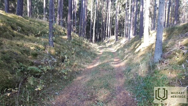
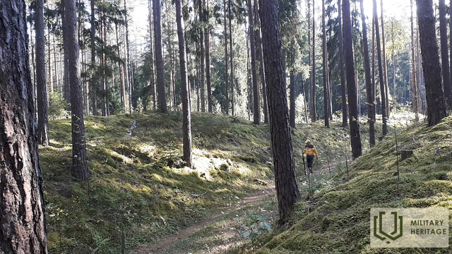
Į pietus ir šiaurę nuo Baldonės–Tomės kelio, V4 (Pirmojo pasaulinio karo žemėlapyje vadinamo „Düna Straße“), Pirmojo pasaulinio karo metu buvo įrengta siaurojo geležinkelio sistema, skirta fronto poreikiams tenkinti. Į pietus nuo minėto kelio buvo „Bhf. (Bahnhoff) Waldl. (Waldlager – „Miško stovykla arba sandėliai“) Salit“ – stotis „Miško stovykla/sandėliai?“. Geležinkelio linijos vietą galima atsekti tiek skirtingų laikų ir mastelių žemėlapiuose, tiek LIDAR žemėlapiuose, tiek gamtoje. Minėta geležinkelio atkarpa atsišakoja nuo šiuolaikinės Vecumniekų stoties (Bhf. Neugut Kurland) – Mercendarbės (Merzendorf) plačiojo geležinkelio maždaug už kilometro į rytus nuo Gēdiņu namų (stotis – „Bahnhoff Gedeng“). Pirmasis geležinkelio linijos kilometras nuo Gēdiņu stoties šiandien apaugęs mišku, o norint rasti linijos vietą gamtoje, reikia pasiimti LIDAR žemėlapius ir kantrybės, bristi apaugusiu, bet vis dar matomu geležinkelio pylimu. Abiejose geležinkelio linijos pusėse, prie greta esančio kelio ir kopos pylime (į pietus nuo kelio), gamtoje matomos mažiausiai 20 gilių, stačiakampių duobių (sandėlių?). Toliau... 1,3 km geležinkelio liniją gamtoje galima atsekti kaip gražų, skaidrų miško kelią, kuris vietomis kerta nedidelius kopų pylimus su juose išraižomis. Toliau – 3,5 km geležinkelio linija sutampa su Latvijos valstybinių miškų nutiestu keliu, kuris, staigiai pasukęs į šiaurės vakarus, geležinkelio linija toliau juda šiaurės rytų kryptimi ir po 0,3 km pasiekia buvusios stoties (Bhf. Waldl. Salit) vietą, kuri aiškiai matoma LIDAR žemėlapyje. Iš stoties gamtoje nieko neišliko, tačiau apylinkėse matyti daug įvairaus gylio ir formos iškastų duobių, o kopų pylimuose, juosiančiuose stoties vietą, – apkasų liekanos. Prieš minėtą stotį matoma kopų iškasa, kur geležinkelio linija tęsiasi šiaurės kryptimi. Ties Silių namais ji kirto Silupius (Kausupi) (buvusi stotis „Bhf. Sille“), tačiau ties Podniekių namais ji atsišakoja. Pirmoji atšaka pasuko dešinėn į Berkavą, antroji – kairėn į Vilkų kalnus ir grįžo prie plačiojo geležinkelio (1435 mm) Skarbės stotyje.
Panaudoti šaltiniai ir literatūra:
1. Žemėlapis „1914 – 19 Karte des Weslichen Russlands“
2. Žemėlapis: JS Baltija, 3.5 versija
3. Latvijos nacionalinės bibliotekos žemėlapių kolekcija, žemėlapis „Zusammendruck Riga, Gezeichet u.gedruckt vd Vermessungs – Abt.18., 1: 100 000“.
