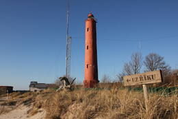
Aizliegtās bākas un jūras krasts

PSRS laikos jūras piekraste Ziemeļkurzemē un Rietumkurzemē faktiski bija apmeklējumam slēgtas militāras zonas, bet bākas apmeklēt un pat fotografēt bija aizliegts
Kad jūras vēstures un bāku pētnieks Arvis Pope nolēma uzrakstīt savu pirmo grāmatu par bākām, viņam nācās apbraukāt ar īpaši izsniegtu atļauju aizliegto Kurzemes jūras krastu un, protams, ka gribējās bākas arī nofotografēt. Taču oficiāli tas bija liegts, jo bākas bija militāri objekti, tās uzraudzīja robežsargi un tā laika drošības struktūras. Nācās to mēģināt darīt slepus, pašam esot krūmu un meža koku aizsegā. Pie tam fotofilmas bija steigšus jāmaina un jāpaslēpj. Vārdusakot, jārīkojas gluži kā spiegu filmās. Jo bāku tuvumā atradās robežsargu daļas un kā izrādās, pat Kolkas ragā ar fotoaparātu rādīties nebija ieteicams.
Pāvilostas pusē esot bijis tā – Arvis jautājis kādam vīram, kurš darbojies ar slotu – sak, kur te var iziet un droši pastaigāt pa jūras malu? Vīrs viltīgi pasmaidījis un teicis - ja iesi pa labi, tur pabrīdinās un tad šaus. Bet ja iesi uz otru pusi- tur šaus bez brīdinājuma, tur ir raķešnieki!
Turpat Pāvilostā iegājuši grāmatnīcā un ieraudzījuši uz plaukta Latvijas karti. Tā kā pašiem tā bijusi jau pamatīgi noplīsusi un nolietota, nolēmuši nopirkt sev jaunu. Un kaimiņam Rīgā arī vēl vienu paņēmuši. Kad izgājuši no grāmatnīcas, nejauši atskatījušies un pamanījuši pārdevēju veikala logā. Tā jau ar kādu runājusi pa telefonu, turpinājusi uzmanīgi vērot svešos pircējus un pierakstījusi atbraucēju automašīnas numura zīmi.
Arvja Popes grāmata par bākām Zvaigznes krastā iznāca 1985. gadā un kā par brīnumu, bāku bildes grāmatā bija palikušas necenzētas. Laikam jau cenzētāji bijuši nekompetenti bāku slepenības jautājumos.

Saistītās laikalīnijas
Saistītie objekti
Mērsraga bāka un krasta robežapsardze
Mērsraga bāka atrodas Mērsraga ciemā, aptuveni 1 km uz ziemeļiem no Mērsraga centra.
Bāka sāka darboties 1875. gadā. Bākas uguns augstums ir 21,3 m. Brīvstāvošs, cilindrisks, kniedēts dzelzs konstrukcijas 18,5 metrus augsts tornis, kura apakšējā daļa nostiprināta ar dzelzsbetona kontraforsiem. Torņa augšdaļā izveidots dzelzs konstrukcijas uz konsolēm balstīts apejas balkons. Bākas tornis izgatavots «Sotera, Lemonjē & Co» fabrikā Parīzē, tāpēc šo bāku tautā sauc par "francūzieti".
Mērsraga apkārtnē karaspēka vienības novietojās sākot ar 1944. gada oktobri. 1944. gada decembra beigās pie bāka pozīcijās novietojās 1003. artilērijas diviziona pirmā baterija ar 60 cm prožektoriem. 1945. gada aprīļa beigās artilērijas bija stipri mazāks. 532. jūras spēku artilērijas diviziona 1. baterija ar četriem 88 mm pretgaisa aizsardzības lielgabaliem, vienu četru stobru 20 mm zenītlielgabalu un trijiem 37 mm zenītlielgabaliem novietojās pie uz dienvidiem no Mērsarga ostas vārtiem. Pašā piekrastē novietoja divus padomju trofeju 45 mm prettanku lielagbalus. Otrā pasaules kara beigās nacistiskās Vācijas vadība plānoja uz Latviju pārcelt latviešu 15. ieroču SS grenadieru divīziju, kurai jau bija paredzēts aizsardzības sektors Mērsraga apkārtnē. Tomēr šie plāni neīstenojās uz latviešu karavīri kapitulēja Rietumu sabiedrotajiem.
Apskate iespējama ar iepriekšēju pieteikšanos, zvanot uz Mērsraga TIC.
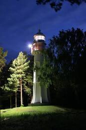
Akmeņraga bāka un kuģa "Saratov" liktenis
Akmeņraga bāka atrodas Sakas pagastā, 10 km uz dienvidrietumiem no Pāvilostas. Bākā var uzkāpt pa vītņveida kāpnēm, no tās paveras skats uz jūru un apkārtnes mežiem. Lai nokļūtu Akmeņragā ir jābrauc vai nu no Pāvilostas (12 km) vai Ziemupes (10 km) puses pa tuvāko ceļu jūras krastam un jāseko norādēm.
Pašreizējais 37 m augstais bākas tornis uzcelts 1921. gadā, bet iepriekšējo bāku nopostīja Pirmā pasaules kara laikā. Pašreizējā 38 metrus augstā bāka uzcelta 1921. gadā un atjaunota 1957. gadā. Pēdejie uzlabojumi veikti vēl mūsu gadsimtā – atjaunots bākas krāsojums. Bākas uguns iedegas reizi 7,5 sekundēs. Pie bākas atrodas neliels ēku komplekss – bijusī robežsargu bāze – savukārt tuvākajā apkārtnē atrodamas vēl citas padomju perioda drupas, kas palikušas no pretgaisa aizsardzības vienību ēkām. 1980. gadu beigās parādījās ideja šeit būvēt atomelektrostaciju – tālāk par mieta iespraušanu zemē projekts gan netika.
Pārējo Latvijas bāku vidū Akmeņraga bāka izceļas ar savu atrašanos kuģošanai vienā no bīstamākajām vietām visā Baltijas jūras piekrastē. Bākas gaisma atzīmē akmeņainu, apmēram divas jūras jūdzes jeb 3,7 km garu sēkli, kurš iesniedzas jūrā ziemeļrietumu virzienā. Jūras dziļums šajā sēklī ir tikai nedaudz virs diviem metriem. Vieta, kur atrodas bāka, palikusi turpat, bet piekraste gadu gaitā atkāpusies.
Neskatoties uz to, ka šeit jau no 1879. gada dega navigācijas uguns, Akmeņrags pieredzējis vairākas kuģa katastrofas. No tām zināmākā ir Latvijas tvaikoņa “Saratow” uzskriešana uz sēkļa 1923. gada septembrī. “Saratow” 1919. gadā uz neilgu laiku kļuva par Latvijas pagaidu valdības mājvietu.
Akmeņragā blakus bākai atradusies Padomju armijas karaspēka daļa, robežapsardzības postenis un krasta baterija, kura demontēta un lielgabali no pozīcijām aizvesti 1955.gadā.
Akmeņraga bākas uzraudze bākas tuvumā ir savākusi skaistu dzintaru un akmeņu kolekciju. Apmeklējumu brīvdienās un svētku dienās vēlams iepriekš saskaņot.
Ovišu bāka un krasta robežapsardze
Ovišu bāka atrodas Tārgales pagasta Ovišos, Kurzemes piekrastē un ir vecākā bāka Latvijā – tā uzcelta 1814. gadā.
Ovišu bākas tornis ir 37 m augsts. Bākai ir dubultcilindra konstrukcija: tās diametrs ir 11,5 m, bet akmeņu mūra iekšpusē ir otrs tornis 3,5 m diametrā. Šāda veida dubultcilindru bākas 18.–19. gadsimtā Eiropā izmantoja arī kā aizsardzības būves ienaidnieka uzbrukuma gadījumam.
Ovišu bākas muzejs tiek uzskatīts par visbagātīgāko bāku aprīkojuma un jūras navigācijas priekšmetu kolekciju starp visu Latvijas bāku muzejiem. Skaidros laikapstākļos no Ovišu bākas var redzēt Irbes bāku.
Otrā pasaules kara beigās Ovišu bākas apkārtnē atradās vācu armijas Beminger bataljona štābs un 530. jūras spēku artilērijas diviziona 4. baterija ar vairākiem zenītlielgabaliem. Iespējams, bākas pakājē atradās radio signālu peilēšanas un infrasarkano staru uztveršanas (Donau Gerät) postenis.
Bākas tuvumā kādreiz atradās padomju robežsardzes postenis, taču līdz mūsdienām padomju laika apbūve vairs nav saglabājusies. Bākas teritorijā joprojām atrodas Ovišu stacijas ēka.
No Ovišiem līdz Venstpilij kāpu zonā bija izveidots tanku ceļš, kas saglabājies arī līdz mūsdienām. To pamazām pārņem mežs.
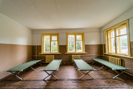
Padomju armijas militārā bāze Pāvilostā - aktīvās atpūtas centrs
PSRS laikā šeit atradās robežsardzes daļa, citas padomju armijas daļas - sakarnieki un zeme - gaiss raķešu bāze atradās vairākus kilometrus tālāk mežā. Pēc neatkarības atgūšanas bija izvietota Latvijas armija.
Kādreizējā padomju armijas militārajā bāze šobrīd ir ierīkots rekreācijas, aktīvās atpūtas un nometņu centrs - personības izaugsmei mijiedarbībā ar dabu un apkārtējiem cilvēkiem.
Vieta atpūtai un nakšņošanai gan tūristu grupām, gan ģimenēm. Istabiņas, dušas, WC, ugunskura vietas, plaša teritorija aktivitātēm, dabas skaņas. Rezervācijas veikt iepriekš, zvanot +371 26314505.
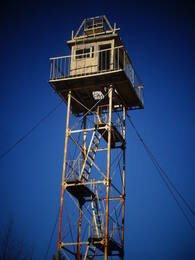
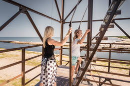
Padomju robežsardzes novērošanas tornis - skatu tornis Pāvilostā
Kādreizējais padomju robežsardzes novērošanas tornis, kuru neizmantoja kopš 90. gadu sākuma, tagad kļuvis par skatu platformu, uz kuras novietots 360 grādu leņķī grozāms sauszemes teleskops un trīs novērošanas kameras. Skaists skats uz jūru un kuģiem, var vērot arī putnus. Tornī atļauts kāpt tikai diennakts gaišajā laikā.Apmeklētājiem jārēķinās ar fizisko un traumatisma risku un jāizvērtē savas spējas un veselības stāvoklis. Skatu tornī un apkārtējā teritorijā notiek videonovērošana. Ziemas sezonā tas apmeklētājiem slēgts.
Pāvilostas novada dome atgādina, ka skatu tornis atrodas militāro objektu aizsardzības zonā, uz Aizsardzības ministrijas īpašumā esošas zemes, kas nodota pašvaldībai lietošanā.
Mazirbes robežapsardzības tornis
Kādreizējais padomju robežsardzes novērošanas tornis atrodas pašā jūras krastā pie stāvlaukuma. Novērošanas torņi atgādina par padomju okupācijas laikiem, kad Mazirbe bija slēgtā pierobežas zona un civilpersonas jūras krastā drīkstēja iziet tikai noteiktās vietās un gaišajā diennakts laikā.
Robežsardzes tornis ir viens no vislabāk saglabājušamies šāda veida objektiem Latvijas piekrastē. Kāpšanai bīstams!
Padomju robežapsardzības postenis bija izvietots kādreizējās Jūrskolas ēkā un tam blakus atrodas labi saglabājies padomju robežsardzes tornītis. Mazirbes jūrskolas komplekss atrodas nedaudz vairāk kā 400m no pludmales torņa.
Nedaudz vairāk par 500m no torņa atrodas Mazirbes laivu kapsēta, ejot no torņa uz Sīkraga pusi (Ovišu virzienā)