Prohibited lighthouses and the sea shore

During the USSR era, the seacoast in North and West Kurzeme were actually military zones closed to the public, but it was forbidden to visit the lighthouses or even take photographs

When Arvis Pope, a researcher of marine history and lighthouses, decided to write his first book about lighthouses, he had to travel around the forbidden shore of the Kurzeme Sea with a special permit and, of course, wanted to take photos of the lighthouses. However, this was officially forbidden because the lighthouses were military installations, supervised by border guards and security structures of the time. I had to try to do it secretly, under the cover of bushes and forest trees. In addition, the photos had to be urgently changed and hidden. In short, you have to act just like in spy movies. Because there were parts of the border guards near the lighthouses and, as it turns out, it was not recommended to show up on the Kolka cape with a camera.
That was the case on the Pāvilosta side - Arvis asked a man who worked with a broom - tell me, where can you go here and walk safely along the sea shore? The man smiled slyly and said - if you go right, he will warn there and then shoot. But if you go the other way - there's a warning there, there's a rocket!
In Pāvilosta, they entered the bookstore and saw a map of Latvia on a shelf. Since it had already been thoroughly torn and worn out, they decided to buy a new one. And the neighbor in Riga also took another. When they left the bookstore, they accidentally looked back and noticed the seller in the shop window. It has already spoken to someone on the phone, continued to watch foreign customers carefully and wrote down the number plate of the arriving car.
Arvja Pope's book about lighthouses on the shore of the Star was published in 1985 and, miraculously, the pictures of lighthouses in the book had remained uncensored. The censors have probably been incompetent on the secrecy of lighthouses.
Arvja Pope's book about lighthouses was published on the shores of the Star in 1985, and miraculously, the pictures of the lighthouses in the book had remained uncensored. The censors have probably been incompetent on the secrecy of the lighthouses.

Related timeline
Related objects
Mērsrags lighthouse and former border guard
Mērsrags Lighthouse is located in the Mērsrags village, about 1 km north of the village centre. The lighthouse was put into commission in 1875. It is an 18.5 m tall freestanding, cylindrical, riveted iron tower, the lower part of which has been fortified with reinforced concrete counterforts. The height of the signal light is 21.3 m. At the top all around the tower there is an iron balcony supported by consoles. The lighthouse tower was made by Sotera, Lemonier & Co in Paris, so this lighthouse is commonly known as the ‘Frenchie’. At the end of 1944, the 1003rd Artillery Division Battery of the German Army with 60 cm spotlights was located right next to the lighthouse. In May 1945, the Nazi Germany high command planned to move the 15th Latvian SS Grenadier Division to the area, but these plans failed, because Latvian soldiers surrendered to the Western Allies. Near the Mērsrags Lighthouse there are still remains of a building where during the USSR times Soviet border guards had a large, extendable spotlight for illuminating the sea. There is a bird-watching tower next to the lighthouse. Tours need to be booked beforehand by contacting the Mērsrags Tourism Information Centre.
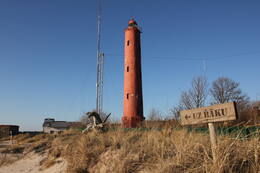
Akmeņrags Lighthouse and the fate of the "Saratov"
The Akmeņrags Lighthouse is located in Saka parish, 10 kilometres southwest of Pāvilosta. The top of the lighthouse can be reached by a spiral staircase and it offers views of the sea and the surrounding forests. Standing at 37 metres high, the current lighthouse tower was built in 1921, while the previous lighthouse was destroyed during World War I.
The Akmeņrags Lighthouse stands out among other lighthouses in Latvia, as it is located in one of the most dangerous places for sailing in the entire Baltic Sea coast. The signal beam of the lighthouse marks a rocky bank, which extends approximately two nautical miles or 3.7 kilometres into the sea in a north-western direction. The depth of the bank is just over two metres. The location of the lighthouse has remained unchanged, but the coastline has been receding over the years. Although a navigation light has been here since 1879, Akmeņrags has seen several shipwrecks. The most notable occurred in September 1923 when a Latvian steamer named Saratow struck the ground. In 1919, Saratow briefly served as the seat of the Latvian Provisional Government. Akmeņrags used to be home to a border guard post, and buildings of the Soviet Army are can be viewed here.
Oviši Lighthouse and Soviet border guard
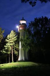
Oviši Lighthouse is located in the Tārgale parish in a village called Oviši on the coast of Kurzeme. It was built in 1814 and it is the oldest lighthouse in Latvia. The height of Oviši Lighthouse tower is 37 m. The lighthouse has a double-cylinder design: its diameter is 11.5 m, but within the stone wall there is a second tower with a diameter of 3.5 m. Such double-cylinder lighthouses were used also as defensive structures in the 18th-19th century Europe in case of enemy attacks. The Oviši Lighthouse Museum is considered to have the largest collection of lighthouse equipment and maritime navigation items among all Latvian lighthouse museums. When the weather is right the Irbe Lighthouse can be seen from Oviši Lighthouse.
At the end of World War II, the headquarters of the Beminger Battalion of the German Army was located near the Oviši Lighthouse along with the 4th Battery of the 530th Naval Artillery Division with several anti-aircraft guns. It is said that there was a radio direction finder and an infrared ray detection station Donau Gerät located at the foot of the lighthouse. A Soviet border guard post was once located near the lighthouse, but none of the Soviet-era buildings have survived. The Oviši station building is still located in the territory of the lighthouse.
Soviet army military base in Pāvilosta - active recreation centre
During the Soviet era, a border guard unit was located here, other Soviet army units - liaison officers and a surface-to-air missile base were located several kilometres away in the forest. After independence, the Latvian army was stationed there.
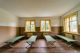
The former Soviet army military base is now a recreation, leisure and camping centre - for personal development in interaction with nature and the people around.
A place for recreation and accommodation for both tourist groups and families. Rooms, showers, WC, fireplaces, spacious area for activities, sounds of nature. Book in advance by calling +371 26314505.
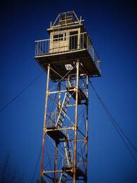
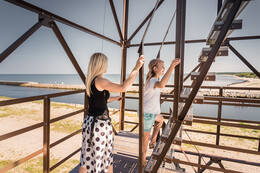
Former Soviet border guard observation tower in Pāvilosta
The Soviet border guard observation tower is located near the South Pier in Pāvilosta. The former Soviet border guard observation tower, which had been out of use since the early 1990s, now serves as a viewing platform with a 360-degree rotating land telescope. It offers beautiful views of the sea and ships and can be used for bird watching. Ascending the tower is only allowed during daylight hours in the summer season. As the stairs in the tower are quite steep, visitors should evaluate their abilities, health and associated risks. The observation tower and the surrounding area has video surveillance. The tower is closed to visitors during the winter season.
Mazirbe border guard tower
The Soviet border defence post was located in the building that used to be a maritime school, and next to it is a well-preserved Soviet border guard watchtower. The second watchtower is located right on the shore next to a parking lot. These watchtowers are a reminder of the Soviet occupation and the times when Mazirbe was a closed border area and civilians were allowed on the shore only in specially designated places and only during the daytime. This border guard watchtower is one of the best-preserved objects of its type on the coast of Latvia. However, it designated is dangerous to climb it.