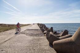
Saksa armee radaripunkt Ulmale'is

Saksa relvajõud paigutasid mitmesse kohta radarijaamad, mis võimaldasid palju varem tuvastada vaenlase lennutegevust Kurzeme piirkonnas.
Saksa sõjaväe radariposti jäänused - raudbetoonist vundamendid - asusid Ulmale'ist umbes 3 km põhja pool.
Kui Punaarmee piiras 1944. aasta oktoobris Kurzeme poolsaare ümber, pidas osa natsi-Saksamaa vägesid Läänemerel peaaegu 8 kuud kestnud lahingut Kurzeme armeegrupi varustamise ja hiljem evakueerimise eest. Merelahingutes mängis eriti olulist rolli lennundus. Seetõttu, et parandada Saksa mereväe võimet võidelda nõukogude lennukitega ja kaitsta Kurzeme rannikut võimaliku nõukogude või isegi lääneliitlaste rünnaku eest, paigutasid Saksa relvajõud mitmesse kohta radarijaamad, mis võimaldasid tunduvalt varem tuvastada vaenlase lennutegevust.
Ulmale ja Jūrmalne'ile paigutati tõenäoliselt Saksa radarsüsteemid FuMG 65 Wurzburg-Riese. Need olid ühed moodsaimad ja kõige sagedamini kasutatavad radarid, mida toodeti umbes 1500 radarimudelit. Sellel oli 7-meetrine paraboolantenn, mis saavutas 9-tonnise kaalu. Radari laskekaugus oli 70 kilomeetrit, mis oli veidi alla poole Gotlandi vahemaast. Radar suutis tuvastada lennukite lähenemist, mis oli eriti oluline hämaral ajal. Selle asukoha abil suunati õhutõrje kiired sihtmärgile, mis omakorda võimaldas kasutada õhutõrje suurtükiväge sihtmärgi hävitamiseks.
Vundamentidest mere suunas on näha veel mõned kindlustuse fragmendid - soomus radari ja õhutõrjekahurite meeskondade jaoks.
(Pilt on illustratiivne)

Würzburg – hiiglaslik FuMG 65 – Saksa radar II maailmasõda – YouTube
https://www.youtube.com/watch?v=1UB9XnKXUus

Seotud ajajoon
Seotud teemad
Seotud objektid
Saksa sõjaväe rannavalve otsetorni asukoht Ussis ja piirivalvepunkt Kolkas
Sõjalist infrastruktuuri Kolka neemele ei planeeritud, välja arvatud mitmed avamere tuletornid, mis ehitati ümber pika aja jooksul kas enne Esimest maailmasõda, Esimese maailmasõja ajal või Teise maailmasõja ajal. Rannakaitsepatareid kavandati Irbe väina kitsamasse ossa, Sirvesi poolsaare ja Mihkli torni tuletorni vahele.
Ainsad sõjalise iseloomuga kindlustused ilmusid 1944. aasta lõpus, kui Saksa armeegrupp Põhja valmistas end ette Nõukogude Balti laevastiku võimaliku maabumise tõrjumiseks. 1945. aasta kevadel, pärast jää taandumist, kaitsesid 532. suurtükiväediviisi kaks patareid rannikut Kolka neemel. 7. patarei nelja 75 mm suurtüki ja kolme 20 mm zenitpüssiga. Patarei 8 nelja 88 mm mürsu, kolme 20 mm mürsu ja ühe 81 mm mürsuga. Deserteritõrje jalaväe garnison koosnes Saksa mereväe ühest tuntuimast rannikukaitseüksusest, 531. suurtükiväediviisi 5. kompaniist. Kuigi see oli nime poolest suurtükiväeüksus, oli see kasutuse poolest jalaväeüksus, mis alustas sõda 1941. aasta juunis Liepāja juures. Seejärel oli üksus garnisonis Soome lahe saartel ja võttis hiljem osa lahingutest Saaremaal. Diviisi jäänused formeeriti üheks kompaniiks ja, tugevdatuna seitsme tankitõrjekahuri ja kolme 20 mm õhutõrjekahuriga, paigutati Kolka neemele.
Nõukogude mereväe maabumisoperatsiooni ei toimunud ja Saksa üksused kapituleerusid 1945. aasta mais.
Sõjalist infrastruktuuri hakati Kolka neemel rajama pärast Teist maailmasõda, kui siia paigutati nõukogude piirivalvepostid ja Kolka, nagu kogu Kuramaa rannik Mērsragist kuni Leedu piirini, muutus suletud tsooniks.
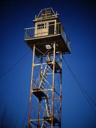
Mazirbe piirivalve vaatlustorn
Nõukogude piirivalvekordon asus endise merekooli hoones. Selle kõrval asus piirivalve vaatlustorn, mis on hästi säilinud. Teine vaatlustorn asub merekaldal parkla juures. Vaatlustornid tuletavad meelde Nõukogude okupatsiooni aega, kui Mazirbe oli suletud piiritsoon ja tsiviilisikud tohtisid mere äärde minna vaid valgel ajal selleks ettenähtud kohtades. Piirivalve vaatlustorn on üks paremini säilinud sedasorti objekte Läti rannikul. Sinna ronimine on ohtlik.
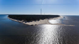
Pūsēni düüni
Pūsēnu mägi asub Bernāti lähedal, 20-minutilise autosõidu kaugusel Liepājast. Pūsēnu mägi on kõrgeim rannikulähedane luide - 37 m kõrge. Düünilt avaneb kaunis vaade ümbruskonnale. Seal on rada merele.
Mäe lähedal on mitmesaja meetri pikkune betoonehitis (tõenäoliselt sõjaväepärand).
Jalutuskäik mööda metsaradu ja piki merepromenaadi.
Karosta põhjapais ja patarei nr 3
Läti pikim muuli - Põhja muuli - ehitati 19. sajandi lõpus Liepaja merekindluse ja sõjasadama väga oluliseks osaks. Muuli pikkus on 1800 meetrit, laius 7,35 meetrit.
Põhjamuuli on üks esimesi keiser Aleksander III sadamastruktuure, mis ehitati aastatel 1890-1892 enne Karosta kanali väljakaevamist. Koos põhjamuuli, lõunamuuli ja lõunamuuliga moodustas muuli Liepaja eeslinnuse.
Liepaja kindluspatarei nr 3 asus Karosta põhjamuuli kõrval ja oli kavandatud suurima relvastusega. Platvormid ehitati neljale 6-tollisele (152 mm) Canet'i süsteemi 1892. aasta mudeli suurtükile, viiele 11-tollisele (280 mm) 1887. aasta mudeli suurtükile ja kahele 57 mm Nordenfeldi tankitõrjekahurile, samuti 18 9-tollisele (229 mm) suurtükile ja mürskudele.
Tänapäeval mõjutab patarei 3 kõige rohkem valitsev lõuna-põhja suunaline merevool, mis tekitab põhjapaisu taga keerisefekti, mille tulemuseks on suurtükiplatvormi vundamentide väljapestud.
Põhjamuuli kaitseb Liepaja sadamaala loodetuulte eest. See on Liepaja elanike ja külastajate lemmikpaik päikeseloojangute vaatamiseks, kalastamiseks ja mere vaatlemiseks erinevates ilmastikutingimustes. Eriti suurejooneline on see tormide ajal.
Põhja muuli juures on piisavalt parkimiskohti. Seal on ka tualettruumid ja kohvik, kust avaneb ainulaadne vaade merele.