German army radar post in Ulmale

The German armed forces deployed radar stations in several locations, which allowed much earlier identification of enemy aviation activity in the Kurzeme area.
The remains of a German army radar post - reinforced concrete foundations - were located about 3 km north of Ulmale.
When the Red Army surrounded the Kurzeme peninsula in October 1944, part of the Nazi German forces fought an almost 8-month battle in the Baltic Sea for the supply and later the evacuation of the Kurzeme Army Group. In the battles over the sea, aviation played a particularly important role. Therefore, in order to improve the German navy's ability to fight Soviet aircraft and to protect the Kurzeme coast from possible Soviet, or even Western Allied, attack, the German armed forces deployed radar stations in several locations, which allowed for a much earlier identification of enemy aviation activity.
In Ulmale and Jūrmalne, German radar systems FuMG 65 Wurzburg-Riese were most probably deployed. These were among the most modern and commonly used radars, with about 1,500 radar models produced. It had a 7 metre parabolic antenna, which reached a weight of 9 tonnes. The radar had a range of 70 kilometres, just under half the distance to Gotland. The radar was able to detect the approach of aircraft, which was particularly important at dusk. Its bearing was used to direct air defence beams at the target, which in turn allowed the use of anti-aircraft artillery to destroy the target.
From the foundations towards the sea, a few more fortification fragments can be seen - armour for radar and air defence gun crews.
(The image is illustrative)

Würzburg - Giant FuMG 65 -- German Radar WWII - YouTube
https://www.youtube.com/watch?v=1UB9XnKXUus

Related timeline
Related topics
Related objects
German army coastguard searchlight site in Usi and border guard post in Kolka
No military infrastructure was planned in Cape Kolka, except for several offshore lighthouses that were rebuilt over a long period of time, either before World War I, during World War I or during World War II. Coastal defence batteries were planned for the narrowest part of the Irbe Strait, between the Sirves Peninsula and the Michael Tower Lighthouse.
The only fortifications of a military nature appeared at the end of 1944, when the German Army Group North was preparing to repel possible landings by the Soviet Baltic Fleet. In the spring of 1945, after the ice retreated, two batteries of the 532nd Artillery Division defended the coast at Cape Kolka. Battery 7 with four 75 mm guns and three 20 mm zenith guns. Battery 8 with four 88 mm mortars, three 20 mm mortars and an 81 mm mortar. The anti-deserter infantry garrison consisted of one of the most famous coastal defence units of the German Navy, the 5th Company of the 531st Artillery Division. Although it was an artillery unit by name, it was an infantry unit by deployment, which started its war in June 1941 at Liepāja. The unit was then garrisoned on islands in the Gulf of Finland and later took part in the fighting on the island of Saaremaa. The remnants of the division were reformed into one company and, reinforced with seven anti-tank guns and three 20 mm anti-aircraft guns, deployed at Cape Kolka.
The Soviet naval landing operation never took place and the German units capitulated in May 1945.
The military infrastructure in Cape Kolka began to be built after the Second World War, when Soviet border guard posts were deployed here and Kolka, like the entire Kurzeme coast from Mērsrags to the Lithuanian border, became a closed zone
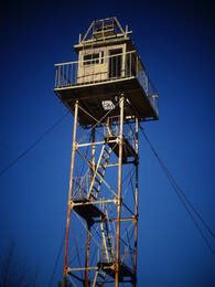
Mazirbe border guard tower
The Soviet border defence post was located in the building that used to be a maritime school, and next to it is a well-preserved Soviet border guard watchtower. The second watchtower is located right on the shore next to a parking lot. These watchtowers are a reminder of the Soviet occupation and the times when Mazirbe was a closed border area and civilians were allowed on the shore only in specially designated places and only during the daytime. This border guard watchtower is one of the best-preserved objects of its type on the coast of Latvia. However, it designated is dangerous to climb it.
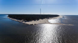
Pūsēni Dune
Pūsēnu Hill is located just outside Bernāti, a 20-minute drive from Liepāja. Pūsēnu Hill is the highest coastal dune - 37 m high. The dune offers a beautiful view of the surrounding area. There is a path to the sea.
Near the hill there is a concrete structure several hundred metres long (probably a military heritage).
Walk along forest paths and along the seafront.
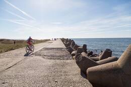
North Pier and Battery No.3 in Karosta
The longest pier in Latvia - the Northern Pier - was built at the end of the 19th century as a very important part of the Liepaja Sea Fortress and military port. The length of the pier is 1800 metres, the width - 7.35 metres.
The Northern Pier is one of the first port structures of Emperor Alexander III, built between 1890 and 1892 before the excavation of the Karosta Canal. Together with the North Breakwater, the South Breakwater and the South Pier, the pier formed the outpost of Liepaja.
Liepaja Fortress Battery No 3 was located next to the North Pier of the Karosta and was planned to be the largest in terms of armament. Platforms were built for four 6-inch (152 mm) guns of the 1892 model of the Canet system, five 11-inch (280 mm) guns of the 1887 model and two 57 mm Nordenfeld anti-tank guns, as well as 18 9-inch (229 mm) guns and mortars.
Today, Battery 3 is most affected by the prevailing south-north sea current, which creates a whirlpool effect behind the North Pier, resulting in the washouts of the gun platform foundations.
The North Pier protects the Liepaja harbour area from North Westerly winds. It is a favourite place for residents and visitors to Liepaja to watch sunsets, fish and watch the sea in different weather conditions. Especially spectacular during storms.
There is ample parking at the North Pier. There are also restrooms and a café with a unique sea view.