Life during World War II on the Kegums side

Memories of the now distant royal era flashed through. For the older generation, it would remind them of their own experiences, while for the younger generation, it might bore them.
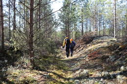
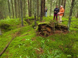
We lived in a very beautiful place on the left bank of the Daugava, about six kilometers from Ķegums. In a place where 12 farmsteads, collectively called Priedesmuiža, are surrounded on one side by a large forest, on the other by the steep bank of the Daugava. Our house was separated from the others by the Ėgupīte, which we called a lake, because near our house it was wider, crossed by two dams. The middle part of one dam is still connected by a concrete bridge, which was saved from destruction by a German soldier. The ends of the other dam extend into the depths, and it no longer boasts the former high wooden bridge. It once served the narrow-gauge railway, along which gravel was transported for the construction of the Ķegums power plant. After the war, the bridge still served, carrying the prevailing symbolism on its sides – sickles and hammers. The tail of the Ėgupīte stretches into the evergreen forest. In the middle of Priedesmuiža there is a children's paradise - large gravel pits with ponds and wild strawberries. At the edge of the forest there are two underground springs with clear water.
June 1941. My mother cried when she found out that the war had started. My sister was ten years old, I was younger. We had a small cottage farm. My stepfather Juris Lazda, a very nice and romantic man, also helped. I can no longer tell the sequence of events, but I remember certain episodes well.
Refugee carts and troops pass our homes day and night. People are sleeping in carts and wagons. Livestock are tied to the backs of carts.
Priedesmuiža is full of Germans. At night, bombers hum hollowly high in the sky. The searchlights try to catch them at the intersections of the beams and they shoot like huge bolts of lightning in the dark vaults of the sky. Here and there they drop a bomb.
Our house was about a hundred meters from the bridge, so my mother, afraid that the house might be ransacked, put her belongings in bags and carried them to the basement at the edge of the forest. While she was coming for the next bag, a man stole the bag and ran into the forest. My mother and I went to the forest and searched under the thick fir trees, hoping that the thief had hidden the bag there to take it again at night. We found a large jar of tomato puree, a new puff pastry, a rifle and some other things. Who would have thought that all kinds of good things grow under the fir trees. But we didn’t find our bag of things.
No bombs hit the bridge, nor the house, but two large craters were knocked out near the basement.
The Germans were not shy about liquidating one pig or one cattle at a time, and imposed a kind of ban on farmers liquidating their own livestock. They assigned the farmer's son, Kārlis, to count the livestock. So, probably against his will, he went around all the houses. He also came to our house. Mother was at the barn at the time. Kārlis did not go into the barn, but asked if we had any pigs. Mother replied that we did not. At that moment, the piglet squealed loudly. Kārlis smiled and said: "I will write that down, that there are none." After that, the stepfather set up a hut and a pen for the piglet in the thicket of the forest and spent the night with it himself.
The Germans threw grenades into the Negupīte, blowing up the fish. The bigger ones were taken, but the smaller ones, with their bellies turned up, washed up along the shores like white waves and smelled bad.
Once, my mother and I were walking along the highway embankment when the shooting started over the embankment, the bullets were whistling. My mother ran down from the embankment and called out to me to follow her. That's when my stubborn nature was revealed. My mother later told the neighbors: "...but that toad doesn't listen, he stands on the embankment and insists that he's not afraid of anything." We children were running everywhere, there was really no fear, and miraculously, not a single bullet hit us.
For a while, the residents were ordered to move into the basement of the Krūmiņi houses, probably for self-defense. The basement under the house was very large and had thick walls. Each family had one of each. We took the most necessary little things with us. The rest was left in the house to fate. Mother buried the potatoes in a hole in the garden and leveled the ground. She buried a barrel of salted pork in the barn under the floor. Chickens roamed everywhere, including a hen named Špicka that I owned. We also had a big, fat, beautiful cat named Janka. While we lived in Krūmiņi, Janka, forced by circumstances, turned into a forest brother.
The Germans set up a horse stable in our barn. Oh, how I loved those horses! They bathed them right there in Negupīte.
Since my foster father was a colporteur in his youth, we had a lot of good books at home. The Germans threw the books into the water, but we found the bookcase in the forest with broken glass. The Germans dug bunkers in the forest and carried tables, chairs, and other furniture from nearby houses into them.
One day, my mother discovered that the Germans had dug up our potatoes, were boiling them, and were feasting on them. Then she went to the stable to save our barrel of meat. A horse was standing right there. My mother told the German stable master to harness that horse and take the barrel of meat to Krūmiņi. The German did not object and obeyed my mother.
The German soldiers liked bacon and eggs best. If we heard the clucking of chickens, then some German or we children would run to look for eggs. Whoever found them first, got them. The Germans often treated us children to chocolates. If a local fell ill, they would go to a German paramedic, who would even give them some medicine.
Once my mother sent me to Lielvārdi to get groceries. I had to walk about three kilometers through the forest, then cross the Daugava River by ferry. On the way back, I unloaded my bag on the side of the road, and looked around. Then I saw Germans coming towards me with a cart, two horses in front. I threw everything in my bag and walked towards them. When they got to the place where I was sitting, they stopped their horses, and one German, shouting something and waving his hand, ran after me. If they run after me, then I have to run, and I run as fast as my legs can carry me. I looked back, he was still running and running. So was I. I ran after the German, and finally he stopped. At home, my mother discovered that I had lost my wallet with money. Then, that's why the German was trying so hard to catch up with me.
We made a little money by collecting berries and mushrooms in Lielvārde and Ķegums, for which we were given so-called points. By showing the points, we could buy products.
Every day, a country kitchen arrived at the Krūmiņi farm – a substantial pot on two wheels. Then the soldiers lined up with pots. I thought I could join that line too. I found a pot and stood at the end of the line. The soldiers smiled. My turn came, and the kind cook filled my pot.
Once I entered the kitchen of Krūmiņi, where the Germans were running the house. A soldier was covered up to his elbows in honey. He was squeezing the honeycombs, and the honey was flowing down his fingers into a bowl. The owner had probably stored the honeydew.
The Germans had a telegraph in the large basement hallway, where a soldier transmitted encrypted messages, but we children stood around, our mouths agape. We were interested in everything.
The Germans installed binoculars on the banks of the Daugava, and when they were not there, the children lined up at the binoculars, and then we saw Lielvārdi up close.
Sometimes at night, my mother and I would come out of the basement and watch from the shore the reflections of fires on the opposite bank of the Daugava, where a house was often on fire. Sparks and plumes of smoke rose against the black sky.
Huge balloons were hoisted above the Kegums power plant. However, the dam of the station was bombed. Something was burning there too, I saw plumes of smoke myself. Later, a rope bridge for pedestrians was hung over the destroyed section, but it swayed a lot.
The waters of the Daugava flowed without obstacles, so it became much narrower and shallower. Ice blocks lay directly on the bed. In the middle of the Žegupīte, the walls of an old mill with a deep pit were revealed. The Germans had sunk boxes of ammunition in the pit. Everyone could take whatever and how much they wanted. The boxes were broken open. They contained shiny cartridges of various sizes and colorful markings. In the yard, incendiary bombs the size of a medium-sized dog were left. The villagers unscrewed them and poured fuel out. The empty bombs served us as a bridge support long after the war. There were also mines, similar in size and shape to cakes. When the deminers arrived, they asked the children where the mines were, and we showed them all around and therefore felt important people.
NRA. 13.07.2004. Back when we had a war.

Related timeline
Related objects
Niega (Melderupe) and its surroundings
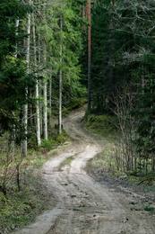
The Ėega River is still called Melderupi on maps from the 1940s. With the construction of the Ķegums HPP, its last 2.6 km were flooded, creating a more than 100 m wide extension of the river. To provide gravel for the construction of the Ķegums HPP, a quarry was created on the eastern bank of the Ėega, and a railway bridge was built across the river. Gravel was transported to the new HPP building by narrow-gauge railway along a 6 km long railway line. The first two kilometers of the railway site are visible both in nature and on LIDAR maps. Further on, the railway site coincides with the modern Jaunjelgava - Ķegums road (P85). On the western bank of the Ėega, about 0.2 km north of the Bridgekeepers' House (the owners have memories of the Second World War and related events in this place), there is a spring - a popular water intake site. Active military activity took place in the vicinity of the Ėega in both world wars of the 20th century. If you look at LIDAR maps and in nature, trench positions are visible north of the P85 road and on the river banks. South of the P85 road, a dune ridge about 0.8 km long adjoins the flooded part of the Ėega from the southwest, the top and slopes of which are dotted with trenches. On the side of the small forest road that connects the P85 road with the Liepdegumi houses, there is a separate dune, the rectangular pits on the slopes of which indicate that buildings or warehouses were located here. The aforementioned dune is surrounded by a strip of trenches about a kilometer long from the north and west. Man-made negative relief forms are also visible south of the P85 road. A dense network of trenches and buildings or/and warehouses (a network of pits of various sizes) is present in nature and is also visible on LIDAR maps on the eastern bank of the Žega between the P85 road and Širmeļupīte. 1.8 km east of Žega is the cemetery of the Lezmaņi brothers. You can reach them along the small forest road that winds around Žega and Širmeļupīte. The third (furthest to the south) trench line marked on the map of the National Library of Latvia ““Zusammendruck Riga, Gezeichet u.gedruckt vd Vermessungs”” is clearly visible on LIDAR maps and in nature even today – a century later.
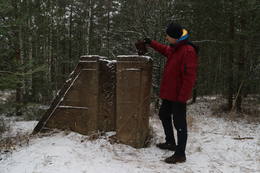
German army concrete fire point at the Ķegums HPP reservoir at the mouth of the Žega River
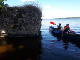
Located in the Ķegums HPP reservoir at the mouth of the Žegums River (opposite the Žegums House), on its left bank. One of the most visually and scenically impressive and also better preserved concrete fire points washed by the waves of the Daugava. It can be seen from a greater distance. A footbridge has been built from the shore to the top of the fire point (overgrown with grass). Narrow-gauge railway (?) tracks are built into the concrete walls of the fire point. You can enter it from the footbridge. This is one of the fire points of the German army's World War I defense line on the left bank of the Daugava, which can be more or less traced along the entire length of the left bank of the Daugava. The aforementioned defense line is a large-scale military system that has not yet been truly evaluated as a single entity. The remains of the fire point can be viewed by boating along the Ķegums HPP.
Prince Leopold Road (Prinz – Leopold Straße)
The name of the World War I site (road) is “Prinz – Leopold Straße” – Prince Leopold’s Road. A historical forest road or its location, about 7 km long, began at the junction of the Great Kurfürsten Damm and Kaiser Damm at the so-called Kurland Monument (Kurland Denkmal) and winds through the forest towards Birzgale, connecting with the World War I narrow-gauge railway line: Lāčplēsis – Latgale. West of the road and about 2 km south of the Kurland Monument (Kurland Denkmal) is a World War I shooting range. Today, the Prince Leopold Road can be walked, cycled and driven (in suitable conditions). The road crosses the Konupīte and a tributary of the Žega.
It is believed that German army soldiers, who spent a long time on the left bank of the Daugava River, named this road after Prince Leopold of Bavaria (1846–1930), who led the German and Austro-Hungarian forces on the Eastern Front during World War I.
Possible location of Otomars Oškalns bunker
A remote and difficult-to-access location is a large forest massif about 200 m west of the Žega River and about 0.5 km southwest of the Žega floodplain. It is recommended to go to the mentioned place on foot or by bicycle, using LIDAR maps and geographical coordinates. In the mentioned place, there is a natural dune ridge about a kilometer long (in the W – E direction) and half a kilometer wide (in the N – S direction), covered with coniferous forest. In the upper parts of the northern and eastern slopes of the dune massif, there are well-preserved trenches, presumably from the Second World War. Harijs Jaunzems (a former engineer of the Ķegums HPP) believes that a bunker of a Red Army partisan unit formed by Otomars Oškalns was located in this area (the specific point is unknown).
Great Electoral Dam (Große Kurfürsten Damm)
The approximately 4 km long, west-east oriented forest road with this name, marked on maps from the First World War, began at the former Kurland Monument (Kurland Denkmal) or later popularly called the Mātīte Monument and ended at the junction of two roads (accessible in the wild) Hütten Straße and Morgen Straße. It stretches for approximately 2 km as a straight forest-dirt road, 0.8 km as a gravel road (coinciding with the Egles-Kaulupe road built by the Latvian State Forests), and the rest as a path – a trail – not passable by car, but passable in the wild or by bicycle. Judging by another map (Zusammendruck Riga, 1: 100 000) and LIDAR maps, a German army camp or warehouses (Lager) were located at the junction of the Great Kurfirst Dam and Morgen Straße during the First World War.
The name, which originated when the German army was stationed here during World War I, is thought to have come from Kurfürstendamm, one of Berlin's central avenues (named after the Electors of Brandenburg), which is today a popular tourist and shopping destination. The name of the avenue was first mentioned between 1767 and 1787.
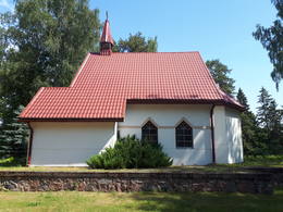
Tome Evangelical Lutheran Church
The first known church in Tome was built in 1644. In 1907–1908, a stone church was built instead of the wooden building with the money of Baron Schilling. In 1956, the church was demolished and a collective farm chicken farm was built from its stones. The church visible today, located between the former Tome elementary school (the school was closed after the school reform, the Ķegums regional museum was established there) and the Tome cemetery, was built between 1999–2003 at the initiative of the Brieži family (USA). The current altarpiece was painted by Sandijs Greiškāns from Ķegums based on a photograph of an altarpiece made by Ata Grunde in 1932. The organ was donated to the church by the Lutheran congregation from Sweden.
In the “Lost Latvia” collection of the National Library of Latvia (LNB), there is a photograph showing the Tome Church during World War I after its destruction in 1916. The Tome Elementary School next to the church also suffered during the battles of the same year.
In the 1938 issue of “Latvijas Kareivī” there is an article “Pa ddimtās zemes istēlstam un ciemiem”, which mentions the Tome Church: … “Furthermore, the road leads past the Tome Church, which was destroyed by the Russians in 1916, thinking it was a German observation post. The small congregation – about 250 members – in 1922 set about renovating the church with great energy and within 10 years built a new tower and altar with an altarpiece by the artist Grunde. Now the church with its white walls, brown window and door frames and neat interior leaves a pleasant impression”.
Former Tome Elementary School
The former Tome Elementary School is located between Baldone-Tome Road (V4, called “Düna Straße” on the World War I map), Tome Evangelical Lutheran Church and Tome Cemetery. The school, like the adjacent church, suffered during the battles of World War I (1916). The National Library of Latvia (LNB) “Lost Latvia” features a photo of the first Tome school in the Siliņi house (1925). The current school building was built in 1926. After the school reform, the school was closed. Today, it houses the Ķegums Regional Museum and Library. On December 13, 2017, a sculpture dedicated to Regina Ezera “Man Needs a Dog”, sculpted by Aigars Zemītis, was unveiled in the museum courtyard. A memorial plaque to the Tome residents deported to Siberia is installed on the wall of the building.
Rata Hill
The highest point of the inland dune massif, located west of the village of Tomes, is Rata Hill (67.8 m above sea level). Light pine forests tower in its vicinity, allowing a good view of the backs and slopes of the impressive dunes. Rata Hill is easily reached on foot (0.6 km) from the Latvian State Forests (LVM) recreation area “Sēņotāju māja”. On both sides of the small forest road, along which we follow towards the hill, more than 40 similar-sized rectangular pits and three trench-like trenches about 50 m long are visible in nature (and on LIDAR maps). It is possible that during the First World War there was a German army warehouse here, surrounded on three sides by the nearby dunes. It is believed that the concrete structures at the highest point of Rata Hill are the remains of a former fire observation (or triangulation?) tower, the wooden parts of which were attached to concrete poles. An article about a ski trip to Rata Hills can be found in a Soviet-era periodical. An annual mushroom picking championship is held in the vicinity of Rata Hills.
Shooting range (Schießstand)
It is located in a larger forest massif between Żega, the former Kurland Monument (Kurland Denkmal) near the so-called Prince Leopold Street (Prinz – Leopold Straße). The object may be difficult to find for the uninitiated, so it is recommended to use geographical coordinates for the search.
Supposedly, - An open-air shooting range built by the German army during World War I for shooting practice. On the map from the time of World War I, this place is marked “Schießst.”. It is believed that it served as a shooting practice site (“Schießstand” in German – shooting range). In the direction towards Tomi (to Tomi), two more shooting ranges are marked on the aforementioned map. The one closest to Tomi can be found and seen in nature.
The area around the shooting range is covered with young pine trees, wolves live in the area (you can find their feces). On LIDAR maps and in nature, a continuous line of trenches 1.5 km long is visible southeast of the shooting range, but in the northwest a line of short (about 50 m long) and interrupted trenches extends all the way to the Ķegums HPP. In nature, the object appears as an approximately 300 m long, straight, northeast-southwest oriented “passage”, which is surrounded on both sides by up to 2 m high ramparts overgrown with lichens and moss. The highest rampart is at the end of the shooting range (3 - 4 m). The shooting range is surrounded by rectangular pits of the same size.