Жизнь на стороне Кегумса во время Второй мировой войны

Вспыхивают воспоминания о далеком военном времени. Старшему поколению это напомнило бы о собственном опыте, возможно, скучающем по молодёжи.
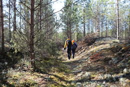
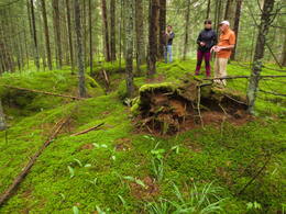
Мы жили в очень красивом месте на левом берегу Даугавы, примерно в шести километрах от Кегумса. В месте, где 12 хуторов, вместе называемых Priedesmuiža, окружены с одной стороны большим лесом, а с другой — крутым берегом Даугавы. Наш дом был отделен от других Негупите, которое мы назвали озером, потому что оно было шире возле нашего дома, пересеченное двумя плотинами. Середина одной из плотин до сих пор соединена бетонным мостом, который спас немецкий солдат. Концы второй плотины достигают дна и она уже не гордится прежним высоким деревянным мостом. Когда-то она обслуживала узкоколейную железную дорогу, по которой были построены гранты для строительства Кегумской электростанции. После войны мост еще служил, неся на боку господствующие символы - серпы и молоты. Хвост негупите тянется в вечнозеленый лес. Посреди сосновой усадьбы детский рай – большие ямы с прудами и земляникой. На опушке леса есть два подземных источника с чистой водой.
июнь 1941 года. Мать узнала, что война началась, плача. Моей сестре было десять лет, я был моложе. У нас небольшая ферма. Помогает и отчим Юрис Лазда, очень милый и романтичный человек. Я уже не могу рассказать последовательность событий, но некоторые эпизоды помню хорошо.
Повозки с беженцами и солдаты движутся по нашим домам днем и ночью. Люди засыпают тут же в колесницах и рудах. Скот привязан к задней части телеги.
Сосновая усадьба полна немцев. Ночью высоко в воздухе ревут полые бомбардировщики. Прожекторы стараются поймать их на пересечениях лучей и выстрелить огромными молниями в темные своды неба. Бросьте бомбы туда-сюда.
Наш дом находился метрах в ста от моста, поэтому моя мама боится, что она может поваляться вокруг дома, сложить его в мешки и отнести в подвал на опушке леса. Пока не пришла следующая сумка, мужчина украл сумку и убежал в лес. Идем с мамой в лес и ищем под большими елками в надежде, что вор спрячет там сумку, чтобы ночью снова взять ее. Мы нашли большую банку томатного пюре, новый пуф, винтовку и другие вещи. Кто бы мог подумать, что под елками растут всякие хорошие вещи. Но мы не нашли нашу сумку.
Ни в мост, ни в дом бомба не попала, но в подвале были выбиты две большие воронки.
Немцы не стыдились искоренять свиней или крупный рогатый скот на основании такого запрета, как запрет на уничтожение фермерами самих животных. Карлиса, владельца Крумини, попросили составить список животных. Так что он, вероятно, ходил по дому против своей воли. Тоже пришел к нам домой. Мать в это время была в сарае. Карлис не петух в хлеву, но он спросил, есть ли у нас свиньи. Мать ответила, что нет. В этот момент свинья громко ухмыльнулась. Карлис улыбнулся и сказал: «Я напишу, что это не так». После этого отчим устроил для свиньи шалаш и периметр в лесной чаще и ночевал у него.
Немцы забросали Негупите гранатами и подорвали рыбу. Те, что покрупнее, подхватили его, а те, что поменьше, вздулись, когда белые волны омывали берега и дурно пахли.
Однажды мы с мамой шли по дамбе шоссе, когда над дамбой началась стрельба, пули свистели одни. Моя мать сбежала с плотины и позвала следовать за ней. Тогда и проявился мой упрямый характер. Мать позже рассказала соседям, «а оно не слушает, стоит на набережной и утверждает, что никого не боится». Мы, дети, везде не боялись, и чудом ни одна пуля не попала в нас.
Некоторое время жители были вынуждены переселяться в подвал дома Крумини, иногда в целях самообороны. Подвал под домом был очень большим и имел толстые стены. Каждая семья имела по одному участку. Нужную щуку мы взяли с собой. Остальные остались в доме судьбы. Мать зарыла картошку в яму и разровняла землю. Бочка солонины разделана в сарае под полом. Курица куда-то ушла, в том числе от имени моей собственной курицы Шпицки. Еще у нас был большой, толстый красивый кот Янка. Живя в Крумини, Янка, вынужденный обстоятельствами, превратился в лесного брата.
Немцы устроили конюшню в нашем сарае. О, как мне понравились эти лошади! Там купались в Негупите.
Поскольку приемный отец в молодости был коллекционером, у нас дома было много хороших книг. Немцы бросили книги в воду, а мы нашли в лесу книжный шкаф с разбитым стеклом. В лесу немцы сбрасывали блиндажи и сносили из близлежащих домов столы, стулья и другую мебель.
Однажды мама обнаружила, что немцы выкопали нашу картошку, сварили ее и развлекались. Потом мы пошли в конюшню, чтобы спасти нашу бочку с мясом. Лошадь стояла прямо там. Мать велела немцу-управляющему подвести лошадь к лошади и отнести бочку с мясом в Крумини. Немец ни против чего не возражал и слушался маму.
Немецким солдатам вкуснее всего было с беконом и яйцами. Если мы слышали говор курицы, немец или мы, дети, бежали искать яйца. Тот, кто нашел это первым, сделал это. Древние часто угощали нас, детей, шоколадками. Если местный житель заболевал, он обращался к немецкому фельдшеру, который даже давал ему лекарство.
Однажды мама отправила меня в Лиелварде за продуктами. Пришлось пройти около трех километров по лесу, потом переправиться на пароме через Даугаву. На обратном пути я выгрузил сумку на обочине. Потом вижу, немцы едут на жеребце, две лошади впереди. Я собрал все в сумку и пошел к ним. Подъехав к тому месту, где я сидел, они останавливают лошадей, и немец, забегая за чем-то и махая рукой, бежит за мной. Если я побегу за ним, я должен убежать, и я вижу, что несут мои ноги. Я оглядываюсь назад, он все еще бежит и бежит. Я также. Я прогнал его, и, наконец, он остановился. Дома мама узнала, что я потерял кошелек. Тогда именно поэтому немец пытался меня поймать.
Немного денег мы заработали, собрав плату за сбор ягод и грибов в Лиелварде и Кегумсе, за что начислялись так называемые баллы. Покупать товары можно было, подарив баллы.
Каждый день в хутор Крумини въезжала деревенская кухня – основательный котел на двух колесах. Затем солдаты выстроились с горшками. Я подумал, что тоже могу присоединиться к этой очереди. Я нашел горшок и подошел к концу очереди. Солдаты улыбаются. Подходит моя очередь, и добрый повар наливает мне полную кастрюлю.
Однажды я зашел на кухню Крумини, которой владеют немцы. Солдат сжал локти медом. Он сжимает ячейки, и мед течет в чаше по его пальцам. Мед, вероятно, хранился у владельца.
В сенях большого подвала для немцев стоял телеграф, куда солдат сдавал шифровки, а мы, дети, стояли кругом, рот глотал. Нас интересовало все.
На берегу Даугавы немцы поставили бинокли, а когда его не было, дети выстроились возле биноклей, и тогда мы увидели Лиелварде вблизи.
Иногда ночью мы с мамой выходили из подвала и смотрели на пожар на противоположном берегу Даугавы, где часто горел дом. Искры и клубы дыма поднимались на фоне черного неба.
Над Кегумской электростанцией разместили огромные воздушные шары. Однако плотины станции подверглись бомбардировке. Там тоже что-то горело, я сам видел пузыри дыма. Позже через разрушенный участок был перекинут вантовый мост, но он сильно раскачивался.
Воды Даугавы текли беспрепятственно, поэтому она стала намного уже и мельче. Ледяные глыбы лежали прямо на кровати. В центре Негупите была обнаружена старая мельничная стена с глубокой ямой. Немцы утопили в яме ящики с боеприпасами. Там каждый мог взять что и сколько хотел. Коробки распахнулись. Они имели яркие патроны разных размеров и цветную маркировку. Во дворе остались огненные шары среднего размера. Селяне открутили их и вылили топливо. Пустые бомбы служили нам для поддержки моста еще долго после войны. Были и мины, похожие по размеру и форме на лепешки. Когда прибыли саперы, они спросили у детей, где мины, и мы все показали им большую площадь, поэтому почувствовали себя важными.
НРА. 13.07.2004 Когда у нас была война.

Связанная хронология
Связанные темы
Связанные объекты
Нега (Мельдерупе) и его окрестности
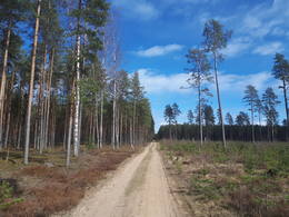
Нега до сих пор называется Мелдерупи на картах 1940-х годов. Вместе со строительством Кегумской ГЭС были затоплены ее последние 2,6 км, в результате чего ширина реки увеличилась более чем на 100 м. Для обеспечения строительства Кегумской ГЭС гравием на восточном берегу Неги построен карьер, через реку построен железнодорожный мост. Гравий транспортировался по железнодорожной ветке протяженностью 6 км к новому строительству ГЭС с помощью узкоколейной железной дороги. Первые два километра участка железной дороги видны как в природе, так и на лидарных картах. Далее участок железной дороги совпадает с современной дорогой Яунелгава - Кегум (P85). На западном берегу Негуса, на севере, примерно в 0,2 км к северу от домов Мостовой стражи (у владельцев сохранились воспоминания о ВОВ и связанных с ней событиях в этом месте), находится источник - народный водозабор точка. Активная военная деятельность велась в окрестностях Неги в обоих 20 веках. в мировых войнах. Если вы посмотрите на карты LIDAR и природу, позиции траншей видны к северу от дороги P85 и вдоль берегов реки. Южнее дороги Р85 к затопленной части Неги с юго-запада примыкает гряда дюн протяженностью 0,8 км, вершина и склоны которой испещрены траншеями. Со стороны небольшой лесной дороги, соединяющей дорогу Р85 с домами Лиепдегуму, стоит стоячая дюна, прямоугольные ямы на склонах которой указывают на то, что здесь располагались постройки или склады. Упомянутая дюна окружена с севера и запада полосой рвов длиной около километра. Искусственные отрицательные формы рельефа также видны к югу от дороги P85. Густая сеть траншей и построек и/или складов (сеть ям разного размера в природе и также видна на лидарных картах на восточном берегу Неги между дорогой Р85 и Ширмелупити. В 1,8 км к востоку от Неги находится р. Кладбище братьев Лезмани. К ним можно пройти по небольшой лесной дороге, которая разворачивается в окрестностях Негаса и Ширмелюпите. Третья линия траншей (самая дальняя к югу) отмечена на карте Латвийской национальной библиотеки "" Zusamendruck Riga, Gezeichet u.gedruckt vd Vermessungs"" хорошо виден на лидарных картах и в природе даже сегодня - столетие спустя.
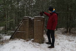
Бетонная огневая точка немецкой армии в водохранилище Кегумской ГЭС у устья Нега
Он расположен в водохранилище Кегумской ГЭС в устье Неги (перед домами Неги), на его левом берегу. Один из самых визуально и живописно впечатляющих, а также наиболее хорошо сохранившихся бетонных каминов, омываемых волнами Даугавы. Это видно из более крупного куска. С берега на вершину огневой точки (заросшей травой) сооружен пешеходный мост. Узкоколейные (?) железнодорожные пути, заделанные в бетонные стены пожарной части. Попасть внутрь можно со стороны пешеходного моста. Это одна из огневых точек линии обороны немецкой армии в годы Первой мировой войны на левом берегу Даугавы, которая более или менее прослеживается на всем протяжении левого берега Даугавы. Вышеупомянутая линия обороны представляет собой масштабную военную систему, которая до сих пор толком не оценивалась в целом. Остатки пожарной точки можно увидеть на лодке на Кегумской ГЭС.
Принц Леопольд Штрассе (Prinz – Leopold Straße)
Название места (дороги) во время Первой мировой войны — «Prinz — Leopold Straße» — дорога принца Леопольда. Историческая лесная дорога длиной около 7 км или место, которое начинается на стыке Гроссе Курфюрстен Дамм и Кайзер Дамм возле так называемого Курляндского Денкмаля и извивается через лес в сторону Бирзгале, соединяясь с узкоколейной железной дорогой времен Первой мировой войны: Лачплесис – Латгали. К западу от дороги и примерно в 2 км к югу от Курляндии Денкмаль находится полигон времен Первой мировой войны. Сегодня по дороге принца Леопольда можно ходить пешком, ездить на велосипеде и водить машину (при подходящих условиях). Дорога пересекает Конупити и приток Нега.
Считается, что солдаты немецкой армии, долгое время стоявшие на переднем крае левого берега Даугавы, назвали эту дорогу в честь баварского принца Леопольда (1846 - 1930), возглавлявшего германские и австро-венгерские войска. на Восточном фронте в годы Первой мировой войны.
Возможное местонахождение бункера Отомарас Ошкалнс
Удаленное и труднодоступное место - большой лесной массив примерно в 200 м к западу от р. Неги и примерно в 0,5 км к юго-западу от поймы Неги. До указанного места рекомендуется дойти пешком или на велосипеде, используя карты LIDAR и географические координаты. В указанном месте имеется внутренняя дюнная насыпь длиной около километра (в направлении З-В) и шириной около полукилометра (в направлении С-Ю), покрытая хвойным лесом. На вершине северного и восточного склонов массива дюн находятся хорошо сохранившиеся траншеи, предположительно времен Второй мировой войны. Харийс Яунземс (бывший инженер Кегумской ГЭС) считает, что в этом районе находился бункер партизанского отряда Красной Армии, сформированный Отомарасом Ошкалнсом (точное место неизвестно).
Гроссе Курфюрстен Дамм
Ориентированная с запада на восток лесная дорога протяженностью около 4 км, отмеченная на картах времен Первой мировой войны, начиналась у бывшего Курляндского Денкмаля (Kurland Denkmal), позже известного как Памятник Матери, и заканчивалась двумя дорогами (проходимыми по своей природе) Hütten Straße. и перекрестки Моргенштрассе. Примерно на 2 км она тянется как прямая лесо-грунтовая дорога, 0,8 км – гравийная дорога (совпадает с дорогой Эглес – Каулупе, образованной Латвийскими государственными лесами), а остальное – дорога, по которой нельзя проехать автомобильным транспортом. , а можно погулять на природе или покататься на велосипеде - т.к. Судя по другой карте (Zusamendruck Riga, 1:100 000) и лидарным картам, на стыке Великой Курфёрст-Дам и Моргенштрассе располагался лагерь или склад немецкой армии времен Первой мировой войны (Лагер).
Считается, что название, родившееся здесь во время пребывания немецкой армии во время Первой мировой войны, происходит от Курфюрстендамм — названия одного из центральных проспектов Берлина (в память курфюрста Бранденбургского), который сегодня является популярным туристическим и торговым центром. Название проспекта впервые упоминается между 1767 и 1787 годами.
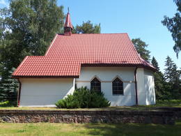
Евангелическо-лютеранская церковь Томеса
Первая известная церковь была построена в Томе в 1644 году. 1907 - 1908 гг. вместо деревянного здания на деньги барона Шиллинга была построена каменная церковь. 1956 г. церковь снесли, а из ее камней построили колхозную птицефабрику. Видимая сегодня церковь, расположенная между бывшей Томесской начальной школой (школа была закрыта после школьной реформы, здесь был создан Кегумский уездный музей) и Томесским кладбищем, была построена в период с 1999 по 2003 год. по инициативе Deer Family (США). Нынешний запрестольный образ был написан Сандисом Грейшкансом из Кегу по мотивам Ата Грунде в 1932 году. фотографии изготовленного запрестольного образа. Орган был подарен церкви лютеранской конгрегацией из Швеции.
В разделе «Потерянная Латвия» Латвийской национальной библиотеки (ЛНБ) можно найти фотографию, на которой изображена церковь Томаса во время Первой мировой войны после ее разрушения в 1916 году. В боях того же года пострадала и начальная школа Томеса рядом с церковью.
«Латвияс Карейви» № 147 за 1938 год содержит статью «О городах и селах родного края», в которой упоминается церковь Томес: «Далее дорога ведет мимо церкви Томес, которая в 1916 г. разрушен русскими, думая, что там находится немецкий наблюдательный пункт. Существует небольшая община - около 250 членов - в 1922 году. с большой энергией принялся за восстановление церкви и в течение 10 лет построил новую башню и алтарь с запрестольным образом работы художника Грунде. Сейчас церковь своими белыми стенами, коричневыми оконными и дверными рамами и аккуратным интерьером оставляет приятное впечатление».
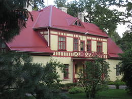
Бывшая начальная школа Томса
Бывшая начальная школа Томеш расположена между дорогой Балдонес - Томеш (V4, называемая «Düna Straße» на карте Первой мировой войны), евангелическо-лютеранской церковью Томеш и кладбищем Томеш. Школа, как и соседняя церковь, пострадала во время боев Первой мировой войны (1916 г.). В «Потерянной Латвии» Латвийской национальной библиотеки (ЛНБ) можно увидеть фотографию первой школы Томеса в доме Силини (1925 г.). 1926 г. построили нынешнее каменное здание школы. После школьной реформы школу закрыли. Сегодня здесь расположены музей и библиотека Кегумского уезда. 2017 13 декабря во дворе музея открылась скульптура «Человеку нужна собака», посвященная Регине Эзер, скульптор Айгарс Земитис. На стене здания установлена памятная доска жителям Томе, депортированным в Сибирь.
Колесо Хилл
Самая высокая точка массива внутренних дюн, расположенная западнее села Томеш, – Рата Калнас (67,8 м над уровнем моря). В его окрестностях растут светлые сосновые леса, откуда открывается хороший вид на спины и склоны впечатляющих дюн. До холма Рата легко добраться пешком (0,6 км) из зоны отдыха «Сеньотаю мая» Латвийских государственных лесов (ЛГЛ). По обеим сторонам небольшой лесной дороги, по которой мы идем в сторону горы, природа (и лидарные карты) показывает более 40 одинаковых по размеру четырехугольных ям и три траншеевидных траншеи длиной около 50 м. Не исключено, что во время Первой мировой войны здесь располагался склад немецкой армии, окруженный с трех сторон близлежащими дюнами. Считается, что бетонные конструкции на самой высокой точке Колесохода — это остатки бывшей пожарной наблюдательной (или триангуляционной?) башни, деревянные части которой крепились к бетонным столбам. Статью о лыжном походе в горы Рата можно найти в журнале советских времен. Ежегодный чемпионат по сбору грибов проходит в окрестностях холма Рата.
Шаутуве (тир)
Предположительно - стрельбище под открытым небом, построенное немецкой армией времен Первой мировой войны для учебных стрельб. Находится в самом большом лесном массиве между Негусом, бывшем Курляндском Денкмале на так называемой улице Принца Леопольда (Prinz — Leopold Straße). Объект может быть трудно найти для непосвященных, поэтому рекомендуется использовать для поиска географические координаты. Окрестности стрельбища покрыты молодыми соснами, поблизости живут волки (можно найти их фекалии). Лидарные карты и природа показывают непрерывную линию траншей длиной 1,5 км к юго-востоку от полигона, а на северо-западе линия коротких (длиной около 50 м) и прерывистых траншей тянется вплоть до Кегумской ГЭС.
В природе объект выглядит как прямой, ориентированный с северо-востока на юго-запад «ход» протяженностью около 300 м, окруженный с обеих сторон валами высотой до 2 м, заросшими лишайниками и мхами. Самый высокий вал находится в конце стрельбища (3-4 м). Стрельбище окружено прямоугольными ямами одинакового размера. На карте времен Первой мировой войны это место обозначено как «Schießst». Предположительно, он служил стрелковым полигоном («Schießstand» по-немецки — стрельбище). По направлению к Томи (до Томея) на упомянутой карте отмечены еще два места стрельбы. Томей можно найти и увидеть в природе, наиболее близкой к природе.