Saving the bridge over the Nega River from being blown up

During the German retreat in 1944, many important objects were blown up and it was very difficult to prevent this, however, there are also stories about miraculous incidents when the courage of local residents and the tolerance of a soldier allow places that are important to the locals to be saved, and the salmon survived. One of the stories is this one about a discussion between a housewife and a German soldier that saved an entire bridge from being blown up.
The story is about the bridge over the Nega River.
When the Germans retreated past our house in the direction of Ķegums, they buried boxes of explosives under the highway bridge at both ends. As they walked away, they unwound a wire behind them to blow up the bridge. Mother stood on the side of the road in despair, thinking that our house would collapse along with the bridge. The last soldier came from the side of the bridge and began to comfort her, so that she wouldn’t cry. Then he rushed after the others. Then mother discovered that the wire had been cut. That’s how this good German soldier saved the bridge. The men lifted the boxes of dynamite out from under the bridge, the children scraped the paraffin off the powder rods and made earthen candles – ploškas.
During the war, sometimes a partisan – a forest brother – would come out of the forest and ask for something to eat. Several years after the war, we learned that about three kilometers from our house there were bunkers of Otomārs Oškalns. There were even signs where to look for them. The place was chosen very well, and the Germans had not found it either. There was thick jungle around, but in the middle there was a dry sand hill and a small river next to it. On the top of the hill, the remains of the bunker logs were still preserved.
NRA. 13.07.2004. Back when we had a war.

Related timeline
Related objects
Niega (Melderupe) and its surroundings
The Ėega River is still called Melderupi on maps from the 1940s. With the construction of the Ķegums HPP, its last 2.6 km were flooded, creating a more than 100 m wide extension of the river. To provide gravel for the construction of the Ķegums HPP, a quarry was created on the eastern bank of the Ėega, and a railway bridge was built across the river. Gravel was transported to the new HPP building by narrow-gauge railway along a 6 km long railway line. The first two kilometers of the railway site are visible both in nature and on LIDAR maps. Further on, the railway site coincides with the modern Jaunjelgava - Ķegums road (P85). On the western bank of the Ėega, about 0.2 km north of the Bridgekeepers' House (the owners have memories of the Second World War and related events in this place), there is a spring - a popular water intake site. Active military activity took place in the vicinity of the Ėega in both world wars of the 20th century. If you look at LIDAR maps and in nature, trench positions are visible north of the P85 road and on the river banks. South of the P85 road, a dune ridge about 0.8 km long adjoins the flooded part of the Ėega from the southwest, the top and slopes of which are dotted with trenches. On the side of the small forest road that connects the P85 road with the Liepdegumi houses, there is a separate dune, the rectangular pits on the slopes of which indicate that buildings or warehouses were located here. The aforementioned dune is surrounded by a strip of trenches about a kilometer long from the north and west. Man-made negative relief forms are also visible south of the P85 road. A dense network of trenches and buildings or/and warehouses (a network of pits of various sizes) is present in nature and is also visible on LIDAR maps on the eastern bank of the Žega between the P85 road and Širmeļupīte. 1.8 km east of Žega is the cemetery of the Lezmaņi brothers. You can reach them along the small forest road that winds around Žega and Širmeļupīte. The third (furthest to the south) trench line marked on the map of the National Library of Latvia ““Zusammendruck Riga, Gezeichet u.gedruckt vd Vermessungs”” is clearly visible on LIDAR maps and in nature even today – a century later.
German army concrete fire point at the Ķegums HPP reservoir at the mouth of the Žega River
Located in the Ķegums HPP reservoir at the mouth of the Žegums River (opposite the Žegums House), on its left bank. One of the most visually and scenically impressive and also better preserved concrete fire points washed by the waves of the Daugava. It can be seen from a greater distance. A footbridge has been built from the shore to the top of the fire point (overgrown with grass). Narrow-gauge railway (?) tracks are built into the concrete walls of the fire point. You can enter it from the footbridge. This is one of the fire points of the German army's World War I defense line on the left bank of the Daugava, which can be more or less traced along the entire length of the left bank of the Daugava. The aforementioned defense line is a large-scale military system that has not yet been truly evaluated as a single entity. The remains of the fire point can be viewed by boating along the Ķegums HPP.
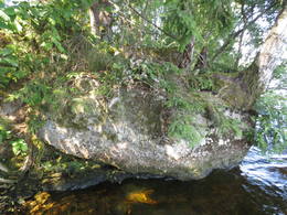
Remains of a German army concrete fire point on the shore of the Ķegums HPP reservoir opposite Silapūpėžys
Located about 0.1 km east of the Ķegums HPP reservoir bay near Silapūpēži, towards Jaunjelgava. The fire point has partially sunk into the water, overgrown with trees, bushes and other vegetation, and to the uninitiated, from a greater distance from the water side, it may resemble a larger stone. One of the landmarks is a birch tree growing on it. This is one of the fire points of the German army's World War I defense line on the left bank of the Daugava, which can be more or less traced along the entire length of the left bank of the Daugava. The aforementioned defense line is a large-scale military system that has not yet been fully evaluated as a single entity. The remains of the fire point can be viewed by boating along the Ķegums HPP. About 150 m east of the Daugava bank, the remains of another fire point have sunk into the water.
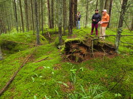
Possible location of Otomars Oškalns bunker
A remote and difficult-to-access location is a large forest massif about 200 m west of the Žega River and about 0.5 km southwest of the Žega floodplain. It is recommended to go to the mentioned place on foot or by bicycle, using LIDAR maps and geographical coordinates. In the mentioned place, there is a natural dune ridge about a kilometer long (in the W – E direction) and half a kilometer wide (in the N – S direction), covered with coniferous forest. In the upper parts of the northern and eastern slopes of the dune massif, there are well-preserved trenches, presumably from the Second World War. Harijs Jaunzems (a former engineer of the Ķegums HPP) believes that a bunker of a Red Army partisan unit formed by Otomars Oškalns was located in this area (the specific point is unknown).
Prince Leopold Road (Prinz – Leopold Straße)
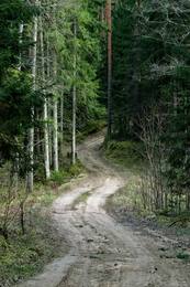
The name of the World War I site (road) is “Prinz – Leopold Straße” – Prince Leopold’s Road. A historical forest road or its location, about 7 km long, began at the junction of the Great Kurfürsten Damm and Kaiser Damm at the so-called Kurland Monument (Kurland Denkmal) and winds through the forest towards Birzgale, connecting with the World War I narrow-gauge railway line: Lāčplēsis – Latgale. West of the road and about 2 km south of the Kurland Monument (Kurland Denkmal) is a World War I shooting range. Today, the Prince Leopold Road can be walked, cycled and driven (in suitable conditions). The road crosses the Konupīte and a tributary of the Žega.
It is believed that German army soldiers, who spent a long time on the left bank of the Daugava River, named this road after Prince Leopold of Bavaria (1846–1930), who led the German and Austro-Hungarian forces on the Eastern Front during World War I.