Vokietijos armijos radaro postas Ulmalėje


Vokietijos ginkluotosios pajėgos keliose vietose dislokavo radarus, kurie leido daug anksčiau nustatyti priešo aviacijos veiklą Kuržemės regione.
Vokiečių armijos radiolokacinio posto liekanos – gelžbetoniniai pamatai – buvo rastos apie 3 km į šiaurę nuo Ulmalės.
Kai 1944 m. spalį Raudonoji armija apsupo Kuržemės pusiasalį, dalis nacistinės Vokietijos pajėgų beveik 8 mėnesius kovojo Baltijos jūroje dėl Kuržemės armijų grupės aprūpinimo ir vėliau jos evakuacijos. Mūšiuose jūroje aviacija atliko ypač svarbų vaidmenį. Todėl, siekdamos pagerinti Vokietijos karinio jūrų laivyno gebėjimą kovoti su sovietų lėktuvais ir apsaugoti Kuržemės pakrantę nuo galimo sovietų ar net Vakarų sąjungininkų puolimo, Vokietijos ginkluotosios pajėgos keliose vietose dislokavo radarus, kurie leido daug anksčiau nustatyti priešo aviacijos veiklą.
Ulmalėje ir Jūrmalnėje greičiausiai buvo dislokuotos vokiškos radarų sistemos „FuMG 65 Wurzburg-Riese“. Tai buvo vieni moderniausių ir dažniausiai naudojamų radarų, pagaminta apie 1500 radarų modelių. Jis turėjo 7 metrų parabolinę anteną, kurios svoris siekė 9 tonas. Radaro veikimo nuotolis buvo 70 kilometrų – beveik pusė atstumo iki Gotlando. Radaras galėjo aptikti artėjančius orlaivius, o tai buvo ypač svarbu sutemus. Jo pelengavimas buvo naudojamas nukreipti oro gynybos spindulius į taikinį, o tai savo ruožtu leido panaudoti priešlėktuvinę artileriją taikiniui sunaikinti.
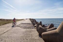
Nuo pamatų jūros link matyti dar keli įtvirtinimų fragmentai – radarų ir oro gynybos pabūklų įgulų šarvai.
(Paveikslėlis yra iliustracinis)
Viurcburgas – Riese FuMG 65 – Antrasis pasaulinis karas Vokietijos radaras – „YouTube“.
https://www.youtube.com/watch?v=1UB9XnKXUus

Susijusi laiko juosta
Susijusios temos
Susijusios vietos
Vokietijos armijos pakrančių apsaugos prožektorių aikštelė Ūsyje ir pasienio apsaugos postas Kolkoje
Kolkos kyšulyje nebuvo planuojama jokios karinės infrastruktūros, išskyrus kelis jūrinius švyturius, kurie buvo atstatyti per ilgą laiką – prieš Pirmąjį pasaulinį karą, Pirmojo arba Antrojo pasaulinio karo metu. Siauriausioje Irbės sąsiaurio dalyje, tarp Sirvės pusiasalio ir Mykolo bokšto švyturio, buvo suplanuotos pakrantės gynybos baterijos.
Vieninteliai karinio pobūdžio įtvirtinimai atsirado 1944 m. pabaigoje, kai Vokietijos armijų grupė „Šiaurė“ ruošėsi atremti galimus sovietų Baltijos laivyno išsilaipinimus. 1945 m. pavasarį, ledui atsitraukus, dvi 532-osios artilerijos divizijos baterijos gynė pakrantę ties Kolkos kyšuliu. 7-oji baterija su keturiomis 75 mm patrankomis ir trimis 20 mm zenitinėmis patrankomis. 8-oji baterija su keturiomis 88 mm minosvaidžiais, trimis 20 mm minosvaidžiais ir 81 mm minosvaidžiu. Priešdezertyrinį pėstininkų garnizoną sudarė vienas garsiausių Vokietijos karinio jūrų laivyno pakrantės gynybos dalinių – 531-osios artilerijos divizijos 5-oji kuopa. Nors pavadinimu tai buvo artilerijos dalinys, pagal dislokaciją tai buvo pėstininkų dalinys, kuris savo karą pradėjo 1941 m. birželį prie Liepojos. Tuomet dalinys buvo dislokuotas Suomijos įlankos salose, o vėliau dalyvavo kovose Saremos saloje. Divizijos likučiai buvo pertvarkyti į vieną kuopą ir, sustiprinti septyniais prieštankiniais ir trimis 20 mm priešlėktuviniais pabūklais, dislokuoti Kolkos kyšulyje.
Sovietų jūrų desanto operacija niekada neįvyko, o vokiečių daliniai kapituliavo 1945 m. gegužę.
Karinė infrastruktūra Kolkos kyšulyje pradėta kurti po Antrojo pasaulinio karo, kai čia buvo dislokuoti sovietų pasienio apsaugos postai ir Kolka, kaip ir visa Kuržemės pakrantė nuo Mērsrago iki Lietuvos sienos, tapo uždara zona.
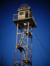
Mazirbės pasienio apsaugos bokštas
Sovietinis pasienio apsaugos postas buvo įsikūręs pastate, kuriame anksčiau buvo jūreivystės mokykla, o šalia jo yra gerai išsilaikęs sovietinis pasienio sargybos bokštas. Antrasis sargybos bokštas yra tiesiai ant kranto, šalia automobilių stovėjimo aikštelės. Šie sargybos bokštai primena sovietų okupaciją ir laikus, kai Mazirbė buvo uždara pasienio zona, o civiliai gyventojai krante buvo leidžiami tik specialiai tam skirtose vietose ir tik dienos metu. Šis pasienio sargybos bokštas yra vienas geriausiai išsilaikiusių tokio tipo objektų Latvijos pakrantėje. Tačiau į jį lipti pavojinga.
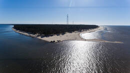
Kopa
Pūsenų kalnas yra netoli Bernatų, 20 minučių kelio automobiliu nuo Liepojos. Pūsenų kalnas yra aukščiausia pakrantės kopa – 37 m aukščio. Nuo kopos atsiveria gražus vaizdas į apylinkes. Yra takas, vedantis į jūrą.
Netoli kalvos stovi kelių šimtų metrų ilgio betoninis statinys (tikriausiai karinis paveldas).
Pasivaikščiokite miško takais ir pajūriu.
Šiaurinis molas ir 3-ioji baterija Karostoje
Ilgiausias molas Latvijoje – Šiaurinis molas – buvo pastatytas XIX a. pabaigoje kaip labai svarbi Liepojos jūros tvirtovės ir karinio uosto dalis. Molo ilgis – 1800 metrų, plotis – 7,35 metro.
Šiaurinis molas yra vienas pirmųjų imperatoriaus Aleksandro III uosto statinių, pastatytas 1890–1892 m., prieš kasant Karostos kanalą. Kartu su Šiauriniu molu, Pietiniu molu ir Pietiniu molu molas sudarė Liepojos užkampį.
Liepojos tvirtovės 3-ioji baterija buvo įsikūrusi šalia Karostos šiaurinio molo ir buvo planuojama, kad ji bus didžiausia ginkluotės atžvilgiu. Buvo pastatytos platformos keturiems 6 colių (152 mm) 1892 m. modelio „Canet“ sistemos pabūklams, penkiems 11 colių (280 mm) 1887 m. modelio pabūklams ir dviem 57 mm „Nordenfeld“ prieštankiniams pabūklams, taip pat 18 9 colių (229 mm) pabūklų ir minosvaidžių.
Šiandien 3-iąją bateriją labiausiai veikia vyraujanti pietų-šiaurės jūros srovė, kuri už Šiaurinio molo sukuria sūkurį, dėl kurio išplaunami patrankų platformos pamatai.
Šiaurinis molas saugo Liepojos uosto teritoriją nuo šiaurės vakarų vėjų. Tai mėgstama vieta Liepojos gyventojams ir lankytojams stebėti saulėlydžius, žvejoti ir stebėti jūrą įvairiomis oro sąlygomis. Ypač įspūdinga audrų metu.
Šiaurinėje prieplaukoje yra daug vietos automobiliams pastatyti. Taip pat yra tualetai ir kavinė su unikaliu vaizdu į jūrą.