
Field railways

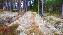
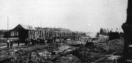
The widespread construction of 600 mm gauge railways can be traced back to the outbreak of World War I, when the German army started building several so-called "war field" (German: "Heeresfeldbahn") railways in the occupied territory of Latvia in 1916.
Given the poor road conditions at the time, the prefabricated railway was the most suitable means of supplying the front in the field of war. The German army had special units specialising in the construction and operation of 'field' railways. The equipment of the "war field" railways, such as rails, wagons and locomotives, which were specially designed for the army, were standardised, which simplified the operation of these railways.
At the front, assembled straight and curved track sections, 5 metres long on 10 iron sleepers, were delivered, which made it possible to construct several kilometres of "field of war" railway in one day in good weather conditions. These railways could be built quickly, or they could be demolished and transported to another front line.
The Austrian, US, French and British armies also had similar units and standardised equipment for wartime field railways.
More information sources

History – Ventspils Museum
Railway objects – Ventspils Museum
railway transport in Latvia - National Encyclopedia (enciklopedija.lv)
Related timeline
Related objects
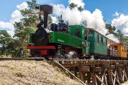
Mazbānītis Railway, Ventspils Seaside Open-Air Museum
In the Seaside Open-Air Museum in Ventspils you can take a ride on two narrow-gauge railway lines with the train ‘Mazbānītis’. The Circle line is 1.4 km and the Mountain line is 3 km. ‘Mazbānītis’ is the locomotive that transported passengers and cargo on 600 mm narrow-gauge railway tracks between 1916 and 1963. It is a legacy of military history from World War I that once played an important role in the cultural and economic development of northern Kurzeme by connecting settlements and providing new jobs.
Construction of a large 600 mm narrow-gauge railway network is largely associated with World War I, when the German Army in 1916 started the construction of several so-called military field railways (Heeresfeldbahn in German) in the occupied territory of Latvia. These railways could be quickly constructed, deconstructed and moved to another front line. The Latvian narrow-gauge railway network was used also during World War II. For almost 60 years the narrow-gauge railway was the only safe way of transporting passengers, various agricultural products and timber to cities in both winter and summer.
Former World War I narrow gauge railway branch: “Banhoff – Bhf. Waldl. Salit” site
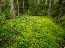
To the south and north of the Baldone-Tomes road, V4 (called “Düna Straße” on the World War I map), a narrow-gauge railway system was established during the First World War to meet the needs of the front. South of the mentioned road was the “Bhf. (Bahnhoff) Waldl. (Waldlager – “Forest camp or warehouses”) Salit” – station “Forest camp/warehouses? The location of the railway line can be traced both on maps of different times and scales and on LIDAR maps, and also in nature. The mentioned railway section branches off from the modern Vecumnieki station (Bhf. Neugut Kurland) – Mercendarbe (Merzendorf) broad-gauge railway approximately a kilometer east of the Gēdiņi houses (station – “Bahnhoff Gedeng”). The first kilometer of the railway line from Gēdiņi station is nowadays covered by forest and in order to find the location of the line in nature, you need to bring LIDAR maps and patience, wading along the overgrown, but still visible railway embankment. On both sides of the railway line, by the adjacent road and in the dune embankment (south of the road), at least 20 deep, rectangular pits (warehouses?) are visible in nature. In the following The 1.3 km railway line can be traced in nature as a nice, clear forest road, which in places crosses small dune embankments with excavations in them. Further - for 3.5 km, the railway line coincides with the road built by the Latvian State Forests, which, turning in a sharp bend to the northwest, the railway line continues to move in a northeasterly direction and after 0.3 km reaches the site of the former station (Bhf. Waldl. Salit), which is clearly visible on the LIDAR map. Nothing has survived from the station in nature, but many dug holes of various depths and shapes are visible in the vicinity, and in the dune embankments that surround the station site - the remains of trenches. Before the mentioned station, a dune excavation is visible, where the railway line continues in a northerly direction. At the Sili houses it crossed Silupi (Kausupi) (former station "Bhf. Sille), but at the Podnieki houses it branched off. The first branch went right to Berkavas, while the second went left to Vilki Hills and then returned to the broad gauge (1435 mm) railway at Skarbe station.
Ķeizerdambis (Kaiser - Damm)
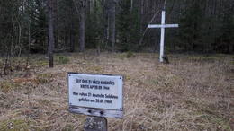
The German army maps of the First World War marked an approximately 8 km long road with this name, starting at the former Kurland Monument (Kurland Denkmal), or later popularly called the Mātīte Monument, and ending at the former Auermann House (Auermann). Today, the Ķeizerdambis, oriented in a northeast-southwest direction, can be walked or cycled along its entire length. It stretches for approximately 4 km as a forest-earth (in places with large gravel chips) road, and 4 km as a gravel road (coinciding with the Abermaņa and Egle - Kaulupe roads built by the Latvian State Forests). The section between the Elge - Kaulupe road and the Abermaņa road is also called the Mātīte path on LVM maps. In its middle section, the Ķeizerdambis crosses a beautiful inland dune massif, in the vicinity of which wartime trenches and construction sites are visible on LIDAR maps. A white wooden cross has been erected near the former Aurmanis house at the site where 21 German army soldiers are buried (who fell around September 20, 1944).
It is possible that the name Kaiserdamm, which originated when the German army was stationed here during World War I, comes from Kaiserdamm – a 50 m wide and 1,680 m long street in Berlin, opened in 1906.
Site of former World War I barracks
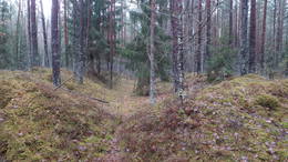
Located in a forest 0.6 – 0.7 km south of the village of Latgale. The best idea of the territory can be obtained if it is previously studied on LIDAR maps, because in nature the positions of trenches and other earth surface formations dug by people a century ago can go unnoticed by the uninitiated. Judging by the remains of a brick kiln and other signs visible in the excavations (carried out by someone else), there were barracks of the German army here. Next to the barracks along the Great Kurfirst Dam from the modern Lāčplēsis station along Birzgali and further to the supply of the Daugava front line, a narrow-gauge railway was built. 0.5 km east of the barracks was the so-called Kurland or Mātīte Monument (Kurland Denkmal), but on the left bank of the Daugava, within a radius of 1.3 km around the barracks, three reinforced concrete fire points were built (surviving to this day, but the remains of one are under water and appear only when the water level of the HPP is reduced), while 0.6 km west of them was a shooting range, of which nothing has survived in nature. Around the shooting range, pits are visible in nature – the remains of former buildings and fortifications. About 100–200 m southeast of the former barracks site, three to 30 m long, rectangular trenches (and smaller ones) are clearly visible in nature, which may have been warehouses.
Narrow gauge railway line during World War I: Lāčplēsis – Latgale
The approximately 22 km long narrow gauge railway line of the First World War, which began at the current Lāčplēsis (Jelgava – Krustpils railway line) railway station (former Bahnhoff Kerghof), skirted Birzgali from the east, crossed the Žega River, then turned west, crossing the modern Abermaņa Road twice (connecting Ķeguma with the Vecumnieki (P88) road) and then along the Ķeizardambi (Kaiser – Damm) to the former Kurland Monument (Kurland Denkmal), where, judging by the LIDAR map visible (divided into three branches?), the final station was located. The Kurland Monument was located 680 m southeast of the Latgali village. The main purpose of the railway was to provide and support the front on the left bank of the Daugava with the necessary. During the First World War, there were German army barracks and warehouses near the Ķeizerdambs, and on the left bank of the Daugava near Puduri (0.6 km) and Podnieki (0.9 km), there were three German army concrete fire points. Today, the location of the railway line can be traced using LIDAR maps in nature. Some parts of it are also clearly visible in nature, especially when vegetation has not grown. The best time to go on an expedition is early spring or winter, when there is no snow.
Prince Leopold Road (Prinz – Leopold Straße)
The name of the World War I site (road) is “Prinz – Leopold Straße” – Prince Leopold’s Road. A historical forest road or its location, about 7 km long, began at the junction of the Great Kurfürsten Damm and Kaiser Damm at the so-called Kurland Monument (Kurland Denkmal) and winds through the forest towards Birzgale, connecting with the World War I narrow-gauge railway line: Lāčplēsis – Latgale. West of the road and about 2 km south of the Kurland Monument (Kurland Denkmal) is a World War I shooting range. Today, the Prince Leopold Road can be walked, cycled and driven (in suitable conditions). The road crosses the Konupīte and a tributary of the Žega.
It is believed that German army soldiers, who spent a long time on the left bank of the Daugava River, named this road after Prince Leopold of Bavaria (1846–1930), who led the German and Austro-Hungarian forces on the Eastern Front during World War I.
Narrow gauge railway line during World War I: Lāčplēsis - Vitkopi
The site of a railway line about 9 km long, which started at the present-day Lāčplēsis railway station (Bhf. Kerghof), and ended at the present-day Witkopu lake (Bhf. Witkop). There were two more stations on the line: Bhf. Sillesemnek (Silenieki) and Bhf. Hasenheide. In nature and on the LIDAR map, north of Lake Witkop (an artificially created reservoir), > 100 pits of various sizes and shapes are visible - presumably, the "traces" of buildings, warehouses, etc. of infrastructure from the First World War. South of the lake is the Witkop brothers' cemetery. With the support of this railway line, the needs of the German army front on the left bank of the Daugava during the First World War were ensured.
Taurkalne German army warehouse site
Approximately 0.7 x 0.4 km large, forested area north of the Jelgava-Krustpils railway and east of the village of Taurkalne, crossed by a forest road and trails. In nature and on LIDAR maps, about 100 rectangular pits dug in straight rows with small ramparts and an exit are visible. According to Daumants Krastiņš: “German warehouses partially buried in the ground. The superstructure has a wooden or corrugated tin roof. Here, some longer ones with entrances at both ends were personnel barracks. Nearby is the normal and rural railway station of the First World War, but during the Second World War the superstructure could be restored and used for the supply of the Nord group, using the nearby Daugava bridge. If ammunition was stored during the Second World War, then they managed to use it until it was airdropped on 19 or 20.09.1944.” Stories from local residents have survived about the German army's underground passages and a dug-in bunker in one of the hills in the area, as well as a German train that "entered underground under the mountain."

Former World War I-era railway: Vecumnieki - Mercendarbe
In 1916, when the German army's front line had strengthened and stabilized along the left bank of the Daugava, on March 15, a decision was made to build a 25 km long railway line with a track gauge of 1435 mm from Vecumnieki (Bhf. Neugut Kurland) to Baldone (station: Mercendarbe - Merzendorf) for the needs of supplying the front. On March 30, about 5,000 workers began work, and by May 1, the line had been built to Skarbe station, and on May 6 – to Mercendarbe. The order of the stations from south to north was as follows: Neugut Kurland, Nougut Nord, Birsemnek, Gedeng, Skarbe, Merzendorf. Cargo was transshipped at the largest of the stations, Skarbe, from where it was transported to the front by horse-drawn transport. As late as 1921, Logs and firewood were transported along the railway line until it was demolished in 1925. The location of the railway line varies greatly in different sections – in places it is crossed by roads of various importance, in places it crosses forest massifs as a clearly visible embankment. There are places that are difficult to pass during the vegetation period.
At the former Gediņi station ("Bahnhoff Gedeng"), a narrow-gauge railway branched off in a northeasterly direction, the tracks of which continued towards the Daugava. At the Sila house it crossed Silupi (Kausupi) (former station "Bhf. Sille"), but at the Podnieki house it branched off. The first branch went to the right to Berkavas, and the second to the left to Vilki mountains and then returned to the broad-gauge (1435 mm) railway at the Skarbe station.
In September 1917, the Germans built another narrow-gauge railway line (gauge of 600 mm) from Mercendarbe and Skarbe to the Daugava, where they built a pontoon bridge and opened traffic all the way to Ikšķile on October 1. The flood of December 4 carried away the aforementioned bridge.
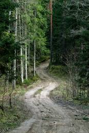
Mazbānītis Trail in Northern Kurzeme
The Mazbānīte is the name given in Northern Kurzeme to a train that transported passengers and cargo along 600 mm wide narrow-gauge railway tracks between 1916 and 1963. It is a legacy of military history from the First World War, which once played a significant role in the cultural and economic prosperity of all of Northern Kurzeme, but especially of Livonian fishing villages, providing a connection between settlements and providing jobs.
The nature trail leads from Mazirbe to Sīkrag along the former Stende - Ventspils narrow-gauge railway track, or as the locals say – mazbānīša track. The construction of the railway began in 1916 and it served until 1963. The narrow-gauge railway line connected the port city of Ventspils with coastal fishing villages, Dundags and the large railway junction in Stende, thus contributing to the economic and cultural prosperity of the region between the First and Second World Wars.
During the Soviet Union, the coast was a "Closed Zone", so coastal villages were economically isolated and their population decreased. The presence of newly built secret military facilities also contributed to the fact that railway traffic was suspended in the 1960s.
The trail has a small loop of 15 km and a large loop of 19 km.
GPX map available here:
https://www.kurzemesregions.lv/projekti/turisms/unigreen/dabas-takas/mazbanisa-dabas-taka/
Stende railway station in narrow gauge railway network and the memorial stone for deportations
The railway line Ventspils - Mazirbe, as well as the Stende - Dundaga extension to Mazirbe with a branch to Pitrags, were intended only for strategic military needs. During the construction of these lines, and afterwards, all civilians were evacuated from the region. The main task of the military railways in the Irbe Strait area was to provide the German army's coastal defence positions with guns and ammunition.
These military-only military railways also connected the three most important lighthouses, located in Oviši, Mikeltornis and Šlītere.
Nevertheless, passenger transport was also provided as early as the years of World War I.
A memorial stone (1989) to the deported Latvians of 1941 and 1949 is located at the Stende railway station.
On 30 October 1919, Stende railway station was occupied by Bermont troops. On 17 November, soldiers of the Latvian army led by K. Šnēbergs attacked the station, driving away a wagon with weapons, war materials and grain. 6 soldiers were awarded the Order of the Order for these battles: K. Bumovskis (1891-1976), P. Strautiņš (1883-1969), R. Plotnieks (1891-1965), E. Jansons (1894-1977).
“Sēlija” Museum in Viesīte
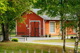
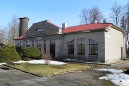
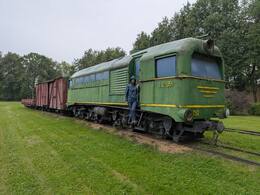
“Sēlija” museum in Viesīte contains several parts: Sēlija House (Sēlija cultural history exhibition) and Tourist Information Point (located in the former railway office building), the former Locomotive Repair Workshop of Viesīte Depot, Crafts Centre and Sēlija narrow-gauge railway history exhibition (located in the Locomotive Repair Workshop building). The most recognisable part of the Museum in Viesīte is the Little Train Park, which is located on the grounds of the former Viesīte Depot.
The narrow-gauge railway was originally built by the German Army from 1915–1916 to transport military cargo, but, after World War I, it was adapted for passenger transport. The museum displays a steam locomotive manufactured by the Schwarzkopff company in 1918, as well as a service cart built in 1916, a freight cart, a timber transport platform, a horsecar, a trolley, and an exhibition on the Sēlija railway. The museum also manages seven historical buildings of the station. The “Mazā Bānīša Parks” (Little Train Park) is friendly for visitors with children.
Not far from the Little Train Park – in the historical Viesīte Station Square – visitors can see the only narrow-gauge railway section in Latvia with a water pump that has been preserved. Several historic buildings are located near the station square: a railway freight warehouse, a cultural centre, a passenger station building and a dispensary.
Vecumnieki Railway Station
Vecumnieki railway station is located south of the village of Vecumnieki.
Vecumnieki railway station was built in 1904 as a station on the Ventspils-Moscow railway line. Initially, it was called “Neugut” (during the German occupation in 1916/1917, it was called “Neugut Kurland”). It gained greater importance during the First World War, when a European-wide railway branch was built from it. In 1916, when the German army's front line had strengthened and stabilized along the left bank of the Daugava, on March 15, a decision was made to build a 25 km railway line with a track gauge of 1435 mm from Vecumnieki to Baldone (station: Mercendarbe - Merzendorf) for the needs of supplying the front. On March 30, about 5,000 workers began work, and by May 1, the line had been built to Skarbe station, and by May 6, to Mercendarbe. The sequence of stations from south to north was as follows: Neugut Kurland, Nougut Nord, Birsemnek, Gedeng, Skarbe, Merzendorf. At the largest of the stations, Skarbe, cargo was transshipped, from where it was transported to the front by horse-drawn transport. This railway existed for only a few years, as late as 1921, logs and firewood were transported along the railway line, until it was demolished in 1925. The location of the railway line is very different in different sections - in places it is crossed by roads of various importance, in places, as the embankment is clearly visible, it crosses forest massifs. There are places that are difficult to pass during the vegetation period.
At the former Gediņi station ("Bahnhoff Gedeng"), a narrow-gauge railway branched off in a northeasterly direction, the tracks of which continued towards the Daugava. At the Sila house it crossed Silupi (Kausupi) (former station "Bhf. Sille"), but at the Podnieki house it branched off. The first branch went to the right to Berkavas, and the second to the left to Vilki mountains and then returned to the broad-gauge (1435 mm) railway at the Skarbe station.
In September 1917, the Germans built another narrow-gauge railway line (gauge of 600 mm) from Mercendarbe and Skarbe to the Daugava, where they built a pontoon bridge and opened traffic all the way to Ikšķile on October 1. The flood of December 4 washed away the aforementioned bridge.
Since 1919, the station has been called Vecmuiža. In 1926, a stone building (architect J. Neijs) was built on the site of the wooden station building destroyed in the war. In 1940, the station was renamed Vecumnieki. On June 14, 1941 and March 25, 1949, several hundred Latvian residents were deported from Vecumnieki station, as well as from many other Latvian railway stations. In total, 44,271 Latvian residents suffered as a result of the deportation actions of March 25, 1949 (until March 30).
In 2000, passenger train traffic was closed on the Jelgava-Krustpils line; currently, this line is used only for freight train traffic.
Narrow gauge railway in Biržai
A 20th-century narrow-gauge railway complex with significant historical, architectural and scenic value.
"Siaurukas" is a 750 mm (2 ft 5 1/2 in) narrow gauge railway, the longest in Europe and one of the most unique heritage sites in Lithuania, therefore the surviving sections of the narrow gauge railway are protected as cultural property. Lithuania has 158.8 km (110 mi) of 750 mm (2 ft 5 1/2 in) narrow gauge railway lines, although only 68.4 km (serving five stations) are in regular use, with 12 locomotives operating. They are included in the Lithuanian Register of Immovable Cultural Heritage Sites.
The narrow-gauge railway line reached Biržai in 1921–1922, when the Biržai–Gubernija railway section was extended. This was the first narrow-gauge railway section built at the expense of the Lithuanian state itself.
In the year of independent Lithuania, 467 km of narrow-gauge railway was built. Forest materials for export, quartz sand, livestock, flax, beets, food supplies were transported along it. Adults went to work by train, and children - to school. On weekends, the train was full of berry and mushroom pickers, and in winter - skiers. Until the terminus of the Guberniya line in the city of Šiauliai, the train stopped at 16 railway stations.
In 1922, a passenger had to pay 7.20 Lithuanian auksinas (German Ostmarks) for one kilometer traveled in a 1st class carriage, and 1.80 Lithuanian auksinas for a 3rd class carriage.
During World War II, the narrow-gauge railway was militarized. It was also used to transport "enemies of the state" - people whom the Soviet authorities considered disloyal (even without any particular reason) - in simple cattle cars for forced deportation to Siberia. After the war, the prospects for the restoration and development of the narrow-gauge railway became very uncertain. The future of the Lithuanian railway was determined by the goals of the Soviet economy and politics.
From 1945 to 1980, more than 400 km of 20 narrow-gauge railway sections were closed. The longest remained the Biržai - Joniškeli and Joniškeli - Panevezys sections, which had a slightly higher freight turnover. 3 trains arrived at Biržai: 2 freight and 1 passenger train. With the expansion and development of road transport, the narrow-gauge railway became economically unstable. In 1988, passenger transport was discontinued. In 1996, during the Independent Republic of Lithuania, the narrow-gauge railway line to Biržai was completely closed.
Today, the narrow-gauge railway complex consists of the depot and station buildings, a water tower, and the old railway section. Later, as a testament to its glorious days, a recently repainted locomotive was brought for viewing.
Aukštaitija barge railway
The Aukštaitija Narrow Gauge Railway (Lithuanian: Aukštaitijos siaurasis geležinkelis) is a 68.4-kilometre (42.5 mi) long tourist railway in Lithuania, running from Panevėžys to Rubikiai, with a track gauge of 750 mm (2 ft 5+1⁄2 in).
The narrow-gauge railway was built from 1891 with a track gauge of 750 mm (2 ft 5+1⁄2 in). The first section was completed on 11 November 1895 from Švenčionėli to Pastovi, and in 1898 it was extended to Panevėžys. Regular passenger and freight traffic began in the autumn of 1899. Initially, there were 2 depots, 14 stations, 15 locomotives, 58 passenger carriages of various types, 6 mail carriages, as well as 112 closed and 154 open freight carriages. In 1903, approximately 65,000 tons of freight and 40,632 passengers were transported.
Panevėžys became a regional center during the period of Lithuanian independence (1920–1938), and therefore many raw materials such as coal, oil, sand, salt and fertilizer were transported, as well as agricultural products such as flax, lard, sugar, grain, flour and timber.
During World War I, the German army built two field railway extensions with a 600 mm (1 ft 11+5⁄8 in) gauge in 1916, from Gubernija to Pasvalija and from Joniškis to Žeimeļi. The railway was functionally important between World War I and World War II and contributed to the economic development of the region. After World War II, it was operated by the state-owned company "Lietuvos Geležinkeliai".
Traffic began to decline in the second half of the 20th century. In 1996, the railway line north of Panevėžys was closed. In the same year, the narrow-gauge railway was included in the List of Immovable Cultural Properties of the Republic of Lithuania and acquired the status of a cultural heritage site. Tourist trains then began to operate. Freight traffic was gradually discontinued in 1999. On 1 November 1999, a new Narrow-Gauge Railway Department was established within the state railway company "Lietuvos Geležinkeliai". However, passenger traffic was temporarily suspended in 2001. Since 2006, tourist trains have been pulled by TU2 diesel locomotives, and they have been well received with increasing passenger numbers.
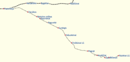
Daudzeva - Sunākstes - Viesītes narrow gauge railway
Viesīte narrow-gauge railway junction – a strategically important railway network in Sēlia
The Viesīte narrow-gauge railway junction was the largest railway network of its kind (600 mm gauge) in Latvia. It operated from 1916 to 1972 and connected several important towns and villages of Sēlija – Nereta, Viesīte, Daudzevu, Jēkabpils, Aknīsti and others. The maximum length of the railway reached 280 kilometers.
Origin and military significance
This railway was built during the First World War – from 1915 to 1916 – along the banks of the Daugava River to ensure the supply of the front and the movement of troops. It was built by the German army with the help of the local population. This was the so-called “castle railway”, which was used for military purposes.
Several lines were built in 1916:
- Skapiški (Lithuania) – Viesīte – Aldaune (100 km),
- Pasmalve – Eglaine – Siliņi (120 km), where this line connected to the previous one,
- Rokiški – Aknīste – Geidāni (50 km),
- Ābeļi – Subate – Kaldabruņa (30 km), where there was a railway triangle for turning trains.
Branches to Bebrene, Dvieti, Zasa and Vandāni were also built. Some of these lines were dismantled in 1920–1927.
In the same year, 1916, the Viesīte–Daudzeva line was also built, with a branch to Sece.
After the war – civil traffic and development
After World War I, some of the lines were demolished, but the rest were incorporated into the Latvian State Railways network. They continued to be used for both freight and passenger transport.
Several lines operated during the interwar period:
- Jekabpils–Nereta,
- Siliņi–Aknīste,
- Guest–Daudzeva,
- Siliņi–Elkšņi (31 km, built in 1932 for forestry work).
In 1936, a vocational school was opened in Viesīte, where railway specialists were trained. In the mid-1930s, 67 passenger carriages, service motorized trolleybuses, snowplows, and Ml series steam locomotives operated at the Viesīte railway junction.
Related stories
The important place of Stende station in the Karalauskas railway network
The main task of the battlefield railways in the Irbes Strait area was to provide the German army's coastal defense positions with cannons and ammunition.
600mm narrow gauge railways in Sēlia
It is often said that war is the father of all things, and that has literally been the case with the Latvian rural railways. Any army, whether attacking or defending, requires considerable resources to ensure warfare. When the German army entered the territory of Latvia in 1915, it faced supply challenges. By the end of 1915, the front had stabilized along the Daugava line. Historically, the population density in the territory of Sēlija was low, and therefore there was no extensive network of transport routes.