Запретные маяки и побережье

Во времена СССР морское побережье в Северном и Западном Курземе было фактически военной зоной, закрытой для посещения, но посещать маяки и даже фотографировать было запрещено.

Когда исследователь морской истории и маяков Арвис Поуп решил написать свою первую книгу о маяках, ему пришлось путешествовать по запретному побережью Курляндии по специально выданному разрешению и, конечно же, фотографировать маяки. Однако официально это было запрещено, поскольку маяки были военными объектами, за ними наблюдали пограничники и силовые структуры того времени. Ему пришлось попытаться сделать это скрытно, под прикрытием кустов и лесных деревьев. Кроме того, фотоплёнки пришлось спешно менять и прятать. Другими словами, приходилось действовать как в шпионском фильме. Ведь рядом с маяками находились пограничные отряды, и, как оказалось, даже на мысе Колка не следовало появляться с фотоаппаратом.
Так было и на стороне Павилосты – Арвис спросил мужчину, работавшего метлой: «Скажи, где можно выйти и спокойно пройти вдоль берега моря?» Мужчина хитро улыбнулся и сказал: «Если пойдёшь направо, тебя предупредят и потом расстреляют. А если пойдёшь на другую сторону – будут стрелять без предупреждения, там ракетчики!»
Тут же, в Павилосте, они зашли в книжный магазин и увидели на полке карту Латвии. Поскольку их карта уже была изрядно потрёпанной и затёртой, они решили купить себе новую. А ещё одну взяли для соседа в Риге. Выходя из книжного магазина, они случайно оглянулись и заметили в витрине продавщицу. Она уже успела с кем-то поговорить по телефону, продолжала внимательно наблюдать за иностранными покупателями и записала номер подъехавшей машины.
Книга Арви Поупа о маяках на Звёздном побережье была опубликована в 1985 году, и каким-то чудом фотографии маяков в ней не подверглись цензуре. Похоже, цензоры проявили некомпетентность в вопросах секретности маяков.

Связанная хронология
Связанные объекты
Маяк и пост береговой погранохраны Мерсрагс (Mērsrags)
Маяк Мерсрагс находится в селе Мерсрагс, примерно в 1 км к северу от центра Мерсрагса. Маяк начал работать в 1875 году. Высота маяка 21,3 м. Маяк представляет собой отдельно стоящую, цилиндрическую, клепанную железную конструкцию, башню высотой 18,5 метров, нижняя часть которой усилена железобетонными опорами. Наверху башни устроен обходной балкон на железных опорах. Башня маяка производится на фабрике «Sotera, Lemonier & Co» в Париже, поэтому этот маяк в народе называют «французиком». В конце 1944 года возле маяка располагалась батарея 1003-й артиллерийской дивизии немецкой армии с прожекторами диаметром 60 см. В мае 1945 года руководство нацистской Германии планировало перебросить в этот район 15-ю латышскую гренадерскую дивизию СС, но эти планы не осуществились, поскольку латвийские солдаты капитулировали перед западными союзниками. Возле маяка Мерсрагс сохранились развалины здания, где во времена СССР для нужд советских пограничников находился большой выдвижной прожектор для освещения моря. Рядом с маяком находится вышка для наблюдения за птицами. Осмотр по предварительной записи. Необходимо связаться с Туристическим информационным центром Мерсрагс.
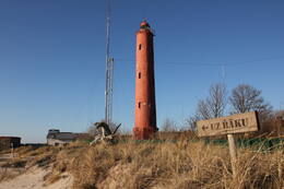
Маяк Акмеенрагс и судьба "Саратова"
Маяк Акменьрагс находится в Сакской волости, в 10 км к юго-западу от Павилосты. На маяк можно подняться по винтовой лестнице, и с него открывается вид на море и окрестные леса. Нынешняя башня маяка высотой 37 м была построена в 1921 году, а предыдущий маяк был разрушен во время Первой мировой войны.
Среди других маяков Латвии маяк Акменьрагс выделяется своим расположением в одном из самых опасных для судоходства мест на всем побережье Балтийского моря. Свет маяка указывает на каменистую отмель длиной около двух морских миль или 3,7 км, достигающий моря в северо-западном направлении. Глубина моря на этой отмели составляет чуть более двух метров. Место, расположения маяка осталось прежним, но берег с годами отступил. Несмотря на то, что навигационный огонь здесь горел ещё с 1879 года, Акменьрагс пережил несколько кораблекрушений. Самое известное из них – посадка на мель латвийского парохода «Саратов» в сентябре 1923 года. В 1919 году Саратов ненадолго стал резиденцией Временного правительства Латвии. В Акменьрагсе располагался пост погранохраны, здесь можно осмотреть здания Советской армии.
Маяк Овиши и береговая погранохрана
Маяк Овиши находится в Таргальской волости, Овиши, на Курземском побережье и является старейшим маяком в Латвии - он был построен в 1814 году. Высота башни маяка Овиши составляет 37 метров. Маяк имеет двухцилиндровую конструкцию: его диаметр составляет 11,5 м, а внутри каменной стены находится вторая башня диаметром 3,5 м. Двухцилиндровый маяк такого типа в 18-19 веках в Европе использовался, в том числе в качестве оборонительного сооружения на случай нападения врага. Музей маяка Овиши обладает самой богатой коллекцией маякового оборудования и предметов морской навигации среди всех маяков-музеев Латвии. В ясную погоду с маяка Овиши можно увидеть маяк Ирбе.
В конце Второй мировой войны в районе маяка Овиши располагался штаб батальона Бемингера немецкой армии и 4-я батарея 530-й морской артиллерийской дивизии с несколькими зенитными орудиями. Вероятно, у подножия маяка находился радиомаяк и инфракрасный приемник (Donau Gerät). Когда-то возле маяка располагался советский пограничный пост, но до наших дней постройки советских времен не сохранились. Здание вокзала Овиши до сих пор находится на территории маяка.
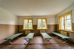
Военная база советской армии в Павилосте - центр активного отдыха
В советское время здесь располагалась пограничная часть, в нескольких километрах в лесу находились другие подразделения советской армии - офицеры связи и база зенитных ракет. После обретения независимости здесь разместилась латвийская армия.
Бывшая военная база советской армии теперь является центром отдыха, досуга и кемпинга - для развития личности во взаимодействии с природой и окружающими людьми.
Место для отдыха и проживания как туристических групп, так и семей. Комнаты, душ, туалет, камины, просторная территория для занятий, звуки природы. Бронируйте заранее, позвонив по телефону +371 26314505.
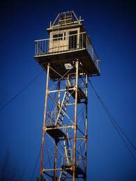
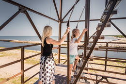
Смотровая вышка Советской пограничной службы - смотровая башня в Павилосте
Советская пограничная смотровая башня находится на Южном пирсе в Павилосте. Бывшая советская пограничная смотровая башня, которая не использовалась с начала 1990-х годов, теперь превратилась в смотровую площадку с вращающимся на 360 градусов наземным телескопом. Отсюда открывается прекрасный вид на море и корабли, можно также понаблюдать за птицами. Подниматься на башню разрешено только в светлое время суток в летний сезон. Поскольку лестница в башне достаточно крутая, посетителям необходимо оценивать свои способности, состояние здоровья и соответствующие риски. На смотровой башне и на прилегающей территории ведется видеонаблюдение. Зимой башня закрыта для посетителей.
Пост погранохраны Мазирбе
Советский пост погранохраны располагался в здании бывшего Морского училища, рядом с ним находится хорошо сохранившаяся советская пограничная вышка. Вторая смотровая вышка находится прямо на берегу моря рядом с парковкой. Смотровые вышки напоминают о временах советской оккупации, когда Мазирбе была закрытой приграничной зоной, и гражданским лицам разрешалось выходить на берег моря только в определенных местах в светлое время суток. Вышка погранохраны - один из наиболее хорошо сохранившихся объектов такого рода на латвийском побережье. Залезать опасно!