
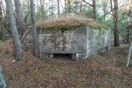
Pillbox
I WW1, II Antrasis pasaulinis karas, IV Sovietų okupacija


Pillidėžė (latviškai taškai, kilusi iš rusiško termino „Дот“ akronimo Долговременная огневая точка) – gelžbetoninė įtvirtinimo konstrukcija, skirta šaudyti įvairiais ginklais ir apsauganti nuo šaulių ir granatų.
Tokios įtvirtinimų konstrukcijos Latvijoje išliko ypač dėl to, kad yra atsparesnės (iš gelžbetonio) gamtos procesams ir žmogaus veiklai.
Daugiau informacijos šaltinių
https://encyclopedia2.thefreedictionary.com/Log+Pillbox


Susijusi laiko juosta
Susijusios vietos
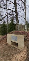
Kunderos piliulės dėžutė
Žuvusio Raudonosios armijos 8-ojo Estijos šaulių korpuso karininko Jakobo Kunderos (ištrinta) memorialas yra kapinėse, 200 metrų į pietvakarius nuo Blidenės-Remtės kelio ir Rygos-Liepojos geležinkelio mazgo.
1945 m. kovo 17 d. prasidėjo paskutinis Raudonosios armijos puolimo bandymas Kuržemėje. Estijos 8-ojo šaulių korpuso 7-osios Estijos šaulių divizijos užduotis buvo pasiekti Rygos-Liepojos geležinkelio liniją į vakarus nuo Blidenės stoties ir užtikrinti 3-iojo gvardijos mechanizuotojo korpuso ataką Gaikų kryptimi. Iki kovo 17 d. vakaro 354-asis šaulių pulkas per mišką pasiekė geležinkelį į pietus nuo Kaulačių dvaro ir tęsė atakas šiaurės vakarų kryptimi. Kadangi 130-ojo Latvijos šaulių korpuso atakos Pilsblidenės dvaro link nebuvo tokios sėkmingos, Estijos 300-ajam šaulių pulkui buvo pavesta kovo 18 d. naktį pulti į vakarus ir pietvakarius, kirsti geležinkelį iš šiaurės ir užimti Blidenės stotį.
Blīdenės stoties apylinkėse jau 1940 m. pavasarį Latvijos armija buvo pastatijusi laikinas kareivines ir sandėlius, kurie buvo pavadinti „kareivinėmis“. 1945 m. Vokietijos armija stoties apylinkėse pastatė keletą požeminių slėptuvių (bunkerių), kuriose žiemą galėjo gyventi kareiviai. Nebuvo jokių įtvirtinimų, nei išmuštų, nei duotų, ir labiausiai tikėtina, kad leitenantas Jakobas Kunderis žuvo artimos kovos metu viename iš bunkerių.
Iškart po mūšio Jakobas Kunderis buvo palaidotas dabartinėse Pilsblidenės kapinėse, o vėliau perlaidotas Tuškų brolių kapinėse.
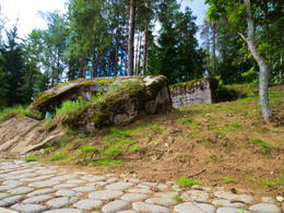
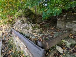
Šiandien galima pamatyti simbolinę sovietinę gelžbetoninės kulkosvaidžio ambrazūros reprodukciją su atminimo lenta.
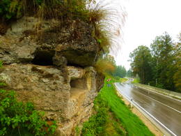
Vokiečių armijos betoninis gaisrinės punktas ant P 87 kelio
Betoninis vokiečių armijos Pirmojo pasaulinio karo laikų ugnies punktas, esantis Dauguvos kairiajame kranto šlaite, 300 m į rytus nuo Tambovičių, netoli Bauskės - Aizkrauklės (P87) kelio. Iš betoninio ugnies punkto išliko dvi šaudymo angos. Po kelio rekonstrukcijos jo aplinka (krantinė) buvo išvalyta nuo krūmų, o objektas dabar gerai matomas važiuojant nuo kelio. Kelias siauras, o šalia objekto nėra kur pastatyti automobilio! Privažiuoti iki objekto sunku, nes šlaitas status, o kartais ir slidus. Nuo kelio atsiveria gražūs Dauguvos slėnio vaizdai.
Vokiečių armijos betoninis ugnies punktas Kegumo HE krante į rytus nuo Lejasgrantinių
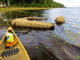
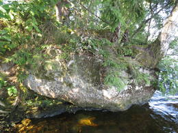
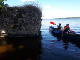
Jis yra apie 0,25 km į rytus nuo nedidelio upelio tęsinio (upelis įteka į Lejasgrantinius) Kegumo HE kranto šlaite. Nuo Jaunjelgavos - Kegumo kelio (P85) jį galima rasti einant Dauguvos krantu (apaugusiu, prieš tai – miško proskyna). Atidus stebėtojas jį pastebės ir nuo upės, nes vasarą čia vešli augmenija. Gaisrinės betoninės dalys apaugusios žaliomis samanomis, angoje matomos metalinės ir medinės konstrukcijos. Kadangi gaisrinė yra dėl Kegumo HE bangų poveikio išplauto kranto pakraštyje, ją lankyti gali būti pavojinga. Netoliese yra gili duobė (bombos duobė?). Tai aštuntasis (nuo Kegumo HE, Jaunjelgavos kryptimi) iš Vokietijos armijos Pirmojo pasaulinio karo gynybos linijos ugnies taškų Dauguvos kairiajame krante, kurį galima atsekti daugmaž per visą Dauguvos kairiojo kranto ilgį. Minėta gynybos linija yra didelio masto karinė sistema, kuri dar nėra iki galo įvertinta kaip vieninga visuma.
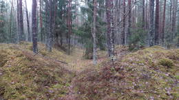
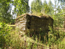
Buvusių Pirmojo pasaulinio karo kareivinių vieta
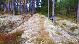
Įsikūręs miške 0,6–0,7 km į pietus nuo Latgalos kaimo. Geriausias vaizdas apie teritoriją susidaro, jei ji prieš tai ištirta LIDAR žemėlapiuose, nes gamtoje prieš šimtmetį žmonių iškastų tranšėjų ir kitų žemės paviršiaus darinių padėtis gali likti nepastebėta nepažįstamojo. Sprendžiant iš plytinės liekanų ir kitų kasinėjimuose (kuriuos atliko kažkas kitas) matomų ženklų, čia buvo vokiečių armijos kareivinės. Šalia kareivinių palei Didžiąją Kurfirst užtvanką nuo šiuolaikinės Lāčplēsio stoties palei Birzgalius ir toliau iki Dauguvos fronto linijos aprūpinimo buvo nutiestas siaurasis geležinkelis. 0,5 km į rytus nuo kareivinių buvo vadinamasis Kurlando arba Mātītės paminklas (Kurland Denkmal), tačiau kairiajame Dauguvos krante, 1,3 km spinduliu aplink kareivines, buvo pastatyti trys gelžbetoniniai ugnies punktai (išlikę iki šių dienų, tačiau vieno liekanos yra po vandeniu ir atsiranda tik sumažinus HE vandens lygį), o 0,6 km į vakarus nuo jų buvo šaudykla, kurios gamtoje nieko neišliko. Aplink šaudyklą gamtoje matomos duobės – buvusių pastatų ir įtvirtinimų liekanos. Maždaug 100–200 m į pietryčius nuo buvusių kareivinių vietos gamtoje aiškiai matomi trys–30 m ilgio stačiakampiai apkasai (ir mažesni), kurie galėjo būti sandėliai.
Siaurojo geležinkelio linija I pasaulinio karo metais: Lāčplēsis – Latgala
Maždaug 22 km ilgio Pirmojo pasaulinio karo siaurojo geležinkelio linija, prasidėjusi dabartinėje Lāčplēsio (Jelgavos–Krustpilio geležinkelio linijos) geležinkelio stotyje (buvusi Bahnhoff Kerghof), iš rytų apjojo Birzgalius, kirto Žegos upę, tada pasuko į vakarus, du kartus kirsdama šiuolaikinį Abermaņa kelią (jungiantį Ķegumą su Vecumniekų (P88) keliu) ir toliau palei Ķeizardambi (Kaiser–Damm) iki buvusio Kuršo paminklo (Kurland Denkmal), kur, sprendžiant iš matomo LIDAR žemėlapio (padalinto į tris atšakas?), buvo galutinė stotis. Kuršo paminklas buvo 680 m į pietryčius nuo Latgalės kaimo. Pagrindinė geležinkelio paskirtis buvo aprūpinti ir paremti frontą kairiajame Dauguvos krante reikalingu turtu. Pirmojo pasaulinio karo metu netoli Ķeizerdambo buvo vokiečių armijos kareivinės ir sandėliai, o kairiajame Dauguvos krante ties Puduriais (0,6 km) ir Podniekiais (0,9 km) buvo trys vokiečių armijos betoniniai ugnies punktai. Šiandien geležinkelio linijos vietą galima atsekti naudojant LIDAR žemėlapius gamtoje. Kai kurios jos dalys taip pat aiškiai matomos gamtoje, ypač kai augmenija dar nesuaugusi. Geriausias laikas leistis į ekspediciją yra ankstyvas pavasaris arba žiema, kai nėra sniego.
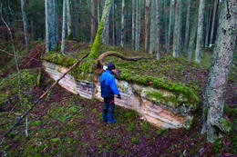
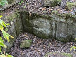
Pirmojo pasaulinio karo įtvirtinimų fragmentas netoli Lesmani brolių kapinių
Jei važiuosite į vakarus nuo Dzintari–Vecumnieki kelio (P88) iki Lezmanų (Lesmaņu, Lessmannų) brolių kapinių, už upelio, kurį reikia kirsti, rasite labai įdomių Pirmojo pasaulinio karo įtvirtinimų liekanų su bunkeriu ir betoninės sienos fragmentu. Sprendžiant iš bunkerių liekanų, apkasų pozicijų ir duobių, matomų gamtoje ir LIDAR žemėlapiuose platesnėje teritorijoje – iki pat Dauguvos, atitinkamu laikotarpiu čia buvo didesnis karinis „kompleksas“ su pastatais, sandėliais, gynybiniais statiniais ir kt. Maždaug už kilometro į šiaurę nuo šios vietos, Dauguvos krante, yra betoninis vokiečių armijos ugnies punktas.
Vokiečių armijos betoninis ugnies punktas Kegumo HE krante netoli Pludinātijų
Įsikūręs pusiasalyje tarp Pludinātijų ir Latgali kaimo. Dėl bangų erozijos objektas nuo kranto šlaito nuslinko iki dabartinio upės vandens lygio. Kai vandens lygis Kegumo HE rezervuare yra aukštesnis, jį nuplauna Dauguvos vanduo. Kai vandens lygis žemesnis, jis visiškai išdžiūsta. Tai vienas iš Vokietijos armijos Pirmojo pasaulinio karo gynybos linijos ugnies taškų kairiajame Dauguvos krante, kurį galima daugiau ar mažiau atsekti per visą Dauguvos kairiojo kranto ilgį. Minėta gynybos linija yra didelio masto karinė sistema, kuri dar nėra iki galo įvertinta kaip vientisas darinys. Ugnies tašką galima gerai pamatyti plaukiant valtimi Kegumo HE. Kita galimybė – pasivaikščioti nedideliu takeliu Dauguvos krantu, kuris veda nuo gerai prižiūrimo paplūdimio „Spārītes“.
Vokiečių armijos betoninis ugnies punktas Kegumo HE krante netoli Puduri
Įsikūręs pusiasalyje prie Konupītės upės (dabar užtvindytos upės tęsinio) žiočių Dauguvoje, Puduri poilsio komplekso teritorijoje. Dėl bangų erozijos ugnies punktas pakrypo upės link. Siekiant išvengti krantų erozijos, rezervuaro krantai sutvirtinti betonine apsaugine siena. Vokietijos armijos gynybos linijos ugnies punktus Pirmojo pasaulinio karo metu galima atsekti daugiau ar mažiau per visą Dauguvos kairįjį krantą. Minėta gynybos linija yra didelio masto karinė sistema, kuri dar nėra iki galo įvertinta kaip vientisas darinys. Ugnies punktą galima gerai pamatyti plaukiant laivu Kegumo HE.
Vokiečių armijos betoninio gaisrinės posto liekanos Kegumo HE rezervuare netoli Podniekių
Įsikūręs Kegumo HE rezervuare, nedidelėje įlankoje, apie 20–30 m nuo Dauguvos kranto, priešais Podniekių namą. Gaisrinės kontūrai išryškėja tik tada, kai Kegumo HE rezervuare vandens lygis žemas. Likusį laiką jie yra po vandeniu ir nematomi. Tai trečiasis (nuo Kegumo HE, Jaunjelgavos kryptimi) Vokietijos armijos gynybos linijos ugnies punktas kairiajame Dauguvos krante Pirmojo pasaulinio karo metu, kurį galima daugiau ar mažiau atsekti per visą Dauguvos kairįjį krantą. Minėta gynybos linija yra didelio masto karinė sistema, kuri dar nėra iki galo įvertinta kaip vientisas darinys. Gaisrinės liekanas esant žemam vandens lygiui galima apžiūrėti plaukiant laivu Kegumo HE.
Vokiečių armijos betoninio ugnies punkto liekanos Kegumo HE rezervuaro pakrantėje priešais Silapūpėžį
Įsikūręs apie 0,1 km į rytus nuo Kegumo HE rezervuaro įlankos netoli Silapūpēžių, Jaunjelgavos link. Gaisrinė iš dalies įgrimzdo į vandenį, apaugo medžiais, krūmais ir kita augmenija, o nepažįstančiam iš didesnio atstumo nuo vandens pusės ji gali priminti didesnį akmenį. Vienas iš orientyrų – ant jos augantis beržas. Tai vienas iš Vokietijos armijos Pirmojo pasaulinio karo gynybos linijos ugnies taškų Dauguvos kairiajame krante, kurį galima daugiau ar mažiau atsekti per visą Dauguvos kairiojo kranto ilgį. Minėta gynybinė linija yra didelio masto karinė sistema, kuri dar nėra iki galo įvertinta kaip vientisas darinys. Gaisrinės liekanas galima apžiūrėti plaukiant valtimi palei Kegumo HE. Apie 150 m į rytus nuo Dauguvos kranto į vandenį įgrimzdo dar vieno gaisrinės liekanos.
Vokiečių armijos betoninio ugnies punkto liekanos Kegumo HE rezervuare priešais Sidrabinius
Įsikūręs apie 0,25 km į rytus nuo Kegumo HE rezervuaro įlankos netoli Silapūpēžių, Jaunjelgavos kryptimi, priešais Sidrabinių ūkį. Gaisrinė iš dalies įgrimusi į vandenį ir suskilusi į kelias dalis, primena statybinių atliekų krūvą. Krantas apaugęs. Tai vienas iš Vokietijos armijos Pirmojo pasaulinio karo gynybos linijos ugnies taškų kairiajame Dauguvos krante, kurį galima daugiau ar mažiau atsekti per visą Dauguvos kairiojo kranto ilgį. Minėta gynybinė linija yra didelio masto karinė sistema, kuri dar nėra iki galo įvertinta kaip vientisas darinys. Gaisrinės liekanas galima apžiūrėti plaukiant valtimi palei Kegumo HE. Apie 150 m į vakarus nuo Dauguvos kranto į vandenį įgriuvo dar vieno gaisrinės liekanos.
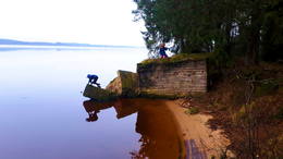
Vokiečių armijos betoninis ugnies punktas prie Kegumo HE rezervuaro Žegos upės žiotyse
Įsikūręs Kegumo HE rezervuare prie Žegumo upės žiočių (priešais Žegumo namus), kairiajame jos krante. Vienas vizualiai ir vaizdingai įspūdingiausių bei geriausiai išsilaikiusių betoninių gaisrinių, skalaujamų Dauguvos bangų. Jį galima pamatyti iš didesnio atstumo. Nuo kranto iki gaisrinės viršūnės (apaugusios žole) pastatytas pėsčiųjų tiltas. Į gaisrinės betonines sienas įmūryti siaurojo geležinkelio (?) bėgiai. Į jį galima patekti nuo pėsčiųjų tilto. Tai vienas iš Vokietijos armijos Pirmojo pasaulinio karo gynybos linijos ugnies taškų kairiajame Dauguvos krante, kurį galima daugiau ar mažiau atsekti per visą Dauguvos kairįjį krantą. Minėta gynybos linija yra didelio masto karinė sistema, kuri dar nėra iki galo įvertinta kaip vientisas darinys. Gaisrinės liekanas galima apžiūrėti plaukiant valtimi Kegumo HE.
Vokiečių armijos betoninio ugnies punkto liekanos Kegumo HE rezervuare priešais Jaundaugulius
Įsikūręs Kegumo HE rezervuaro pakrantėje, apie 0,6 km į rytus nuo Žegos žiočių, priešais Jaundaugulius. Gaisrinės punktas nuslinko nuo kranto į vandenį ir suskilo į kelias dalis. Į jį įaugo du didesni beržai, apaugo tankumynas. Viena jo dalis su krantu sujungta pėsčiųjų tiltu. Tai vienas iš Vokietijos armijos Pirmojo pasaulinio karo gynybos linijos ugnies punktų Dauguvos kairiajame krante, kurį galima daugiau ar mažiau atsekti per visą Dauguvos kairiojo kranto ilgį. Minėta gynybos linija yra didelio masto karinė sistema, kuri dar nėra iki galo įvertinta kaip vientisas darinys. Gaisrinės punkto liekanas galima apžiūrėti plaukiant valtimi Kegumo HE.
Vokiečių armijos betoninis ugnies punktas viršutiniame Kegumo HE krante priešais Andulius
Jis yra apie 1,2 km į rytus nuo nedidelio upelio, išplatėjusio (upelis įteka į Lejasgrantinius) stataus Kegumo HE kranto šlaito viršuje priešais Andulius. Šioje vietoje krantas apaugęs mišku ir krūmynais, todėl tik atidus stebėtojas pastebės šį gaisro tašką iš rezervuaro pusės. Gaisro taškas yra gerai išsilaikęs, nes jo nepažeidė kranto erozija. Tai vienas iš Vokietijos armijos Pirmojo pasaulinio karo gynybos linijos ugnies taškų Dauguvos upės kairiajame krante, kurį galima daugiau ar mažiau atsekti per visą Dauguvos upės kairįjį krantą. Minėta gynybos linija yra didelio masto karinė sistema, kuri dar nėra tinkamai įvertinta kaip vientisas darinys. Gaisro tašką galima apžiūrėti plaukiant valtimi Kegumo HE, nes jis yra privačioje teritorijoje.
Pirmojo pasaulinio karo mūšio laukai
Pirmojo pasaulinio karo metu Daugpilio krašte keletą metų buvo įsikūrusi vadinamoji „Gyvybės ir mirties“ fronto linija, kurioje buvo pastatyta sudėtinga įtvirtinimų sistema. Iki šių dienų Sventės ir Medumi valsčių miškuose išliko daugybė betoninių bunkerių, ginklų ir šaudmenų sandėlių, apkasų, abiejose fronto pusėse kovojusių karių kapų.
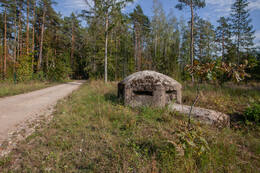
Betoninio bunkerio šaudymo vieta netoli Gaujos kaimo
Įsikūręs Inčukalno savivaldybėje, pakelėje netoli Gaujos kaimo, netoli A2 ir A3 greitkelių sankryžos.
Įtvirtinimas yra labai retas ir vertingas įtvirtinimų pavyzdys. Statinys buvo suprojektuotas taip, kad vienas asmuo galėtų stebėti svarbų eismo mazgą. Į šiaurės vakarus yra tiltas per Gaujos upę, į rytus – pervaža per Inčupytės upę, į pietvakarius – kelių sankryža, o į pietus – vienas iš pagrindinių eismo maršrutų – Vidžemės plentas. Gelžbetoninis įtvirtinimas buvo aplinkinių apkasų dalis, kurių tikslus statybos laikas nežinomas. Labiausiai tikėtina, kad jį pastatė vokiečių armija Antrojo pasaulinio karo metu. Norint patikslinti informaciją, vietovėje reikalingi tolesni tyrimai.
XIX amžiaus pabaigoje Inčukalno dvaro apylinkės tapo svarbiu eismo mazgu. Pirmojo pasaulinio karo metu ši teritorija įgijo gynybinės zonos svarbą, kurioje buvo planuojami galimi karo veiksmai. Įtvirtinimai buvo pastatyti šalia transporto kelių, Inčukalno geležinkelio stoties ir Gaujos upės perėjos. Teritorija išlaikė strateginę svarbą ir vėlesnių karų metu.
Šiandien galite apžiūrėti įtvirtinimus, į kuriuos galima laisvai patekti.
Gynybos linija su 21 kulkosvaidžių bunkeriu (Sarve-Lehtma)
Gelžbetoniniai kulkosvaidžių bunkeriai buvo pastatyti 1941 m. Estų kalboje vartojamas žodis „dott“ yra sovietinės armijos termino „ДОТ“ (долговременная огневая точка) adaptacija, pažodžiui verčiama kaip nuolatinės ugnies taškas. Tai uždara gynybinė konstrukcija, pastatyta iš akmens, betono, šarvuotų čerpių ir kt.
Sarvės-Lehtmos gynybos linijoje nebuvo daug karinių veiksmų, nes priešas atvyko iš netikėtos krypties. Gynybos linija buvo pastatyta rytinėje ir šiaurinėje Hyjumaa pakrantėse, tačiau vokiečių desantas pietinėje pakrantėje pasirodė 1941 m. spalį. Sarvės-Lehtmos gynybos linijos kulkosvaidžių bunkeriai yra tokio paties tipo sunkiųjų kulkosvaidžių pozicijos, skirtos 2–3 pabūklininkams. Yra keletas nedidelių skirtumų (ambrazūrų skaičius, prieškambario forma ir vieta ir kt.). Šie statiniai buvo pastatyti skubotai, naudojant karo sąlygomis turimas medžiagas, todėl statybų kokybė skyrėsi.
Šiandien bunkeriai beveik neatlieka jokios funkcijos. Heltermoje vienas iš bunkerių naudojamas kaip rūsys, o Sääre kyšulyje – kaip RMK (Valstybinio miškų valdymo centro) apžvalgos aikštelės pagrindas. Gelžbetonio būklė patenkinama, trūksta metalinių langinių ir ambrazūrų durų. Kai kurie bunkeriai yra miške taip smarkiai apaugusiame, kad jų neįmanoma pastebėti.
Hyjuma saloje yra beveik 50 kulkosvaidžių bunkerių, tačiau tik čia jie sudaro stabilią ilgą gynybos liniją. Dauguma jų yra aplink pakrantės baterijas. 1970 m. pasieniečiai įrengė tris SPS-3 kulkosvaidžių bunkerius iš surenkamųjų gelžbetonio plokščių, vienas iš jų (iš Suursadamos pozicijos) buvo išsiųstas į Hyjuma karo muziejų.
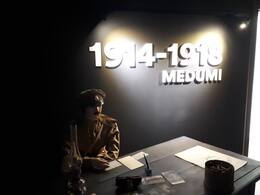
Pirmojo pasaulinio karo muziejus
Aršiausi Pirmojo pasaulinio karo mūšiai Latvijos teritorijoje vyko netoli Daugpilio – 1915 m. rugpjūtį ir spalį Ilūkstės ir Medumų aukštumose. Vokiečiai bandė prasiveržti į Daugpilį, tačiau rusai juos nustūmė atgal. Nė viena pusė neįgijo pranašumo, todėl abi pusės ėmė kasti apkasus ir suformavo trijų linijų ešelonuotos gynybos padėtis. Abiem pusėms nesisekė, todėl jos ėmė statyti tranšėjas, kurdamos nuodugnios gynybos pozicijas, sudarytas iš trijų linijų. Pirmojo pasaulinio karo muziejus Medumuose skirtas šiems mū šiams atminti. Pirmoji ekspozicijos dalis supažindina su Medumų krašto istorija ir rodo, kad prieš karą tai buvo gausiai gyvenama ir išvystyta vietovė.
Antroji dalis pasakoja apie Pirmojo pasau linio karo įvykius Europoje ir Latvijoje, pristato karių gyvenimo sąlygas bei karo metu atsiradusias naujoves, taip pat ekspo nuojami vokiečių ir rusų kariuomenių naudoti ginklai. Trečiojoje ekspozicijos salėje lankytojai gali įsijausti į kareivio gyvenimą – čia atkurta rusų bunkerio kopija su apkasų fragmentu, nedi dele slėptuve, karo lauko atributais ir kareivių manekenais. Ka dangi mediniai rusų kariuomenės bunkeriai iki šių laikų neišliko, jie rekonstruoti muziejaus ekspozicijoje, o betoninius vokiečių kariuomenės bunkerius galima pamatyti keliaujant tarptautiniu maršrutu, vedančiu per Pirmojo pasaulinio karo vietas. Bunke rio imitacijos salėje naudojama garso ir vaizdo įranga sukuria autentišką karo lauko atmosferą.
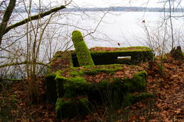
Remains of a German army concrete firing point on an island in the Pļaviņa HPP reservoir
Located on a small island (about 0.2 km long) in the Pļaviņas HPP reservoir, which is located close to the coast, opposite Baloži and Jāņa Kūpinātava. The island was created by forming the Pļaviņas reservoir and raising the water level, because before that it was part of the Daugava valley coast. The island is covered with a forest with thick undergrowth, where it is difficult to move. The fire point (suffered from shelling? blown up?) has only two well-preserved walls. It does not have a roof part.
The firing points of the German army's defensive line during World War I can be traced more or less along the entire length of the left bank of the Daugava from Ķegums to the Pļaviņas HPP reservoir, inclusive. The aforementioned defensive line is a large-scale military system that has not yet been properly assessed as a unified whole.
The fire point can be seen well from a boat. It will be more difficult to find from the shore.
Remains of a German army concrete fire point on the banks of the Plavinas HPP
Located in the head of a small bay of the Pļaviņas HPP reservoir between Bitānes and Baloži, approximately opposite the Čoči cemetery. The fire point is perfectly camouflaged on a small dolomite rock ridge, merging with the surrounding landscape, over which the foliage of trees bends, so it is difficult for an uninitiated person to notice it. The remains of the fire point are located close to the water level (when it is not lowered in the reservoir) and can be recognized by the metal rods with which the contour of the structure was reinforced. The waves of the reservoir have severely eroded the shore.
The firing points of the German army's defensive line during World War I can be traced more or less along the entire length of the left bank of the Daugava from Ķegums to the Pļaviņas HPP reservoir, inclusive. The aforementioned defensive line is a large-scale military system that has not yet been truly evaluated as a unified whole.
The fire point can be seen well from a boat. It will be more difficult to find from the shore.
Susijusi istorija
Olmanių pakrantės baterija
Į šiaurę nuo Ventspilio yra dar viena svarbi pakrantės baterija. Jis buvo Olmanyje ir vadinosi „Krasnoflotskaya“.
„PZ“ – pasienio zona
Vērgalės kaimo liaudies deputatų tarybos pirmininko Andrio Zaļkalno (1982-1989) prisiminimai apie gyvenimą pasienio zonoje.
Sovietų Sąjungos didvyrio žygdarbis - leitenantas Jakobas Kunderis iš 8-ojo Estijos korpuso
Didvyriški žuvusio Raudonosios armijos Estijos 8-ojo šaulių korpuso karininko Jakobo Kunderos veiksmai užtikrino sėkmingą bataliono puolimą, tačiau jis pats žuvo, o Jakobui Kunderai žuvimo vietoje yra skirtas paminklas, Tuškų brolių kapinėse pastatytas paminklas.