Saaremaa and Hiiumaa – Outpost of the Estonian Sea Border
Piiri Missile Base
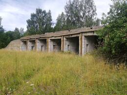
This former missile base is situated on state forest land in Piiri on the island of Muhu.
It was completed in 1963. To neighbouring village Liiva the missile base for S-125 system was established at the end of 1960s.
The air defence missile division was designed to defend the western border of the Soviet Union. The division comprised around 16 officers and 60 conscripts. The base had an electric generator, a bunker, a command centre and hangars for S-75 missiles. There was also a separate hangar, presumably for a 3 nuclear warhead missile (probably an OTR-21 Tochka) missiles.
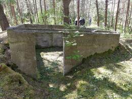
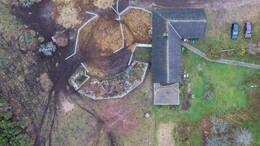
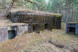
The missile hangars, the garages, the bunkers and the ruins of the command centre and a pillbox with firing holes are what remain of the base today.
WWI Defense Ditches at Väike Väin Strait
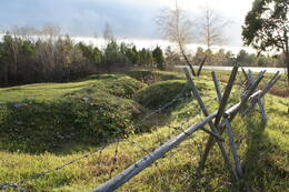
The clearly visible segment of World War I trenches by the Väike Strait is situated next to the Kuivastu-Kuressaare road near the popular tourist attraction of Eemu Windmill on the island of Muhu.
These trenches make up a small part of a larger area of defensive fortifications and facilities covering many kilometres. They were dug from 1915-1917 as a defensive measure against the advancing German army and were used during both world wars.
The renovated site is a great example of the military history of Muhu. This zigzagging trench is clearly visible. It is easily accessed by visitors, as it is situated right by a main road with a car park next to it. Historic wire fencing only adds to the scenery.
This example of military history complements the historic Eemu windmill, an industrial heritage site nearby, which survived World War I but was destroyed in World War II, before being restored in 1980.
Military Equipment Museum of Saaremaa
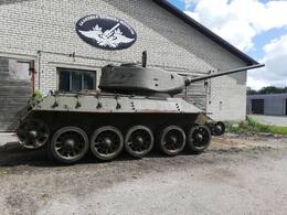
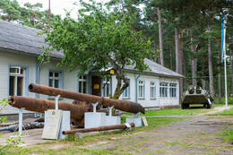
The Military Equipment Museum on Saaremaa was established in 2007. Its collection comprises the private items (approximately 12,000 of them) of its founding members.
The museum organises themed hikes and re-enactments of historical battles showcasing the military history of the 20th century. Covering 650 m2, the museum comprises five exhibition halls open to visitors, including an outdoor exhibition (of larger military equipment). The centrepiece of the War of Independence Hall is the machine gun wagon of the 3rd Armoured Train. The exhibition displays original uniforms, weapons and other personal equipment from the War of Independence (1918-1920). The Hall of Historical Uniforms displays the original uniforms of the Estonian Defence Forces and Defence League from the interwar era (1925-1940) and original uniforms from World War II, along with other equipment. The Hall of Weapons displays European firearms and sidearms from 1450-1970. The Hall of World War II Personal Equipment and Kitchenware provides an overview of soldiers' everyday items. The Hall of Technical Equipment displays communication devices, cannons, mortars, bicycles, motorcycles and cars.
Saaremaa Museum
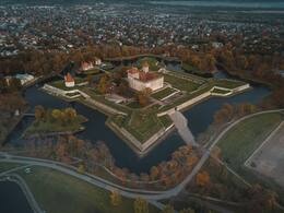
Kuressaare Castle is situated on the southern edge of the Kuressaare town, by the sea.
The anniversary of Saaremaa Museum, which is housed in the fortress, is celebrated on 17 February: the date in 1865 when the Society for Research of Saaremaa (Verain zur Kunde Oesels) was founded. The museum relocated to the castle in 1897. Its exhibition showcases the nature and history of Saaremaa. The largest and most noteworthy exhibit at the museum is the castle itself, which a fine example of the development of military fortifications between the 14th and the 19th centuries. Kuressaare Castle is one of the most authentic fortifications anywhere in Northern Europe.
Monument to the Night Battle of Tehumardi
At 8 o'clock on the evening of 8 October 1944 during World War II, the Red Army clashed with retreating German troops in the village of Tehumardi in Sõrve. The battle took place at the 18 km mark on the Kuressaare-Sääre road.
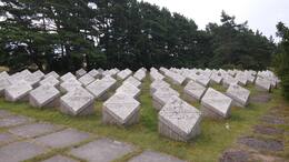
A monument was unveiled nearby in 1966, when a Red Army cemetery was also opened in memory of the confrontation. The 21-metre monument depicts a concrete sword, its cross-guard adorned with the faces of soldiers. The cross-guard bears an inscription reading: "1941-1945. To the Soviet soldiers and defenders and liberators of Saaremaa" in Estonian and Russian. The cemetery in Tehumardi features 90 dolomite tablets engraved with the names of the Red Army soldiers who fell.
A couple of hundred metres from the cemetery along the road towards Sõrve, a large granite monument appears on the right-hand side of the road. It was unveiled on 15 July 2012 and placed at the approximate site of the battle. The monument bears a tablet reading: "Here, on 8 October 1944, the Night Battle of Tehumardi broke out."
The cemetery in Tehumardi has been removed in 2024, but the memorial pillar remains, albeit with some of the text partially obscured.
Coastal Battery No 43 at Sõrve Säär
This coastal defence battery is situated on the shores of the Gulf of Riga in the village of Sääre on Saaremaa.
Sääre was the site of the 43rd coastal battery of the Moonsund forward position of Peter the Great's Naval Fortress, also known as Zerel. It comprised four 305-mm guns. Construction began in 1914, during World War I, on a limited budget. The artillery pieces were mounted in the open on barbettes, with a narrow firing range over Irbe Strait. These were accompanied by ammunition dumps, diesel generators and a command centre built from logs and surrounded by sand. The wooden fire control tower was around a kilometre away at Sääre Manor. A 5 km long narrow gauge railway was laid connecting the battery with the port in Mõntu.
The concrete artillery barbettes with their rounded bolts, defensive walls of two of the artillery positions and the mound of sand on which the command centre once stood are all that remain today.
Stebel Coastal Battery No 315, Command Post
This Coastal Defence Battery Command centre is situated in a now deserted part of the village of Sääre.
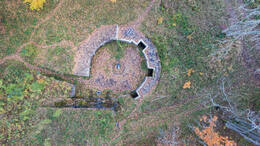
The coastal defence battery was named after its commander, Captain Aleksandr Stebel. Construction began in May 1940 and the battery was completed shortly before the outbreak of World War II. The battery deterred German marines in Lõu Bay and provided covering fire for the Red Army’s Lõpe-Kaimri defensive line. The artillery was destroyed during the Red Army retreat in October 1941, after which the lower levels of the barbettes were flooded. The complex comprised two artillery barbettes mounting two 180-mm guns, a command centre, a fire control tower in the shape of a windmill, a generator and a heating plant.
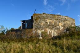
Unfortunately, these intriguingly engineered battery positions are situated on private property and are difficult to locate. As such, anyone interested will have to make do with viewing the command centre from the outside, as its lower level is submerged. The centre was drained in 2010, but had filled up with water again just a few months later.
Papissaare Seaplane Base
This seaplane harbour is situated on Papissaare Peninsula, to which an historic cobbled road leads from the small borough of Kihelkonna.
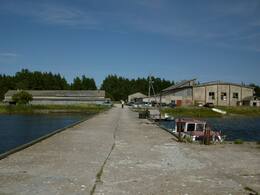
Papissaare Seaplane Base, which formed part of Peter the Great's Naval Fortress, was established between 1912 and 1914. It comprised two aircraft hangars, equipment and ammunition warehouses, a fuel tank, an electric generator, barracks, a canteen, a bread factory and a bathhouse. In August 1914, nine aircraft were brought here from Liepāja. On 12 October 1917 German forces captured the base and destroyed most of the buildings. During the interwar era the complex was the site of Julius Teär's Shipyard.
On 24 October 1939, Soviet forces acquired the complex under the Mutual Assistance Pact and restored it as a seaplane harbour. The MBR-2 seaplanes of the 15th Aviation Squadron stationed here fought in the Finnish Winter War. In late summer 1941, German bombers obliterated the seaplanes. The Soviet squadron abandoned the base, setting it on fire as they did so. From 1940-1960 the whole peninsula was a restricted military zone. Later, the complex was used by the local fishing collective. Today the remaining buildings are in use as workshops and warehouses.
This historic seaplane harbour has become an important tourism port, providing passage to the unique island of Vilsandi.
Panga Military Trail
This military hiking trail is situated on the north coast of Saaremaa, 1.5 km north-west of the village of Panga. The most convenient access to Panga is via Võhma.
The trail is situated along Panga Bank, which is the highest bank of exposed bedrock anywhere in Western Estonia and on the islands. Its length and openness to the sea are what make the bank special in terms of terrain and attractive to tourists. It is situated in Panga Nature Park, surrounded by the Baltic Sea to the north and north-east, by the mouth of Küdema Bay (an important bird site) to the west and by forests to the south and east.
Panga Bank did not see any active combat. The area was used for defence purposes, as it was a restricted access zone on the border of the Soviet Union.
The sundial marks the place where a searchlight once stood, guarding the national border.
Today the 2 km long military hiking trail passes by the ruins of a variety of military facilities.
120-mm Battery No 34 at Hindu (Sõru)
The construction of the battery began in 1914. As it was an additional battery, missing in the original plan of the naval fortress and the type of guns was repeatedly changed. Finally four 120- mm Vickers guns were installed. A 200-m length and 10-20-m width sandbar was piled up in defence of the gun emplacements and covered in concrete above the guns. Hindu was the only battery in Hiiumaa that participated in combat operations during the Tagalahe landing on 12 October 1917. After a brief exchange of fire with the German warships the Russian artillerymen fled, leaving the battery intact. The Germans sent a landing unit of soldiers inland that blew up the guns of the battery. One of the German warships that shot Hindu battery, was ’Bayern’, the warship with the largest displacement that has ever been in the Estonian waters (length 180 m, displacement 32 200 tons, eight 380-mm guns).The building of the battery radio station was transported to Emmaste and was used as the community centre (demolished in the 1980s). The gun barrels and other larger details were still there in 1937. Today the first and the second gun platforms are still identifiable, the other two are situated on a fenced farmyard. The third gun crater is filled with earth and there is a newly built house facing the sea, the remains of the fourth one is merely a cracked concrete platform. Out of two air defence gun platforms, one survives (a hundred metres toward the nursing home, on the right side of the road). There are no intact buildings. The machine gun bunker between the first and the second emplacement was completed in 1941.
Concurrently with the construction of Hindu battery, there was a plan to build something in Lepiku village where large gravel bars were piled up, still visible today. It is unknown what the building was going to be.
130-mm Coastal Battery No 44 at Tohvri (Hindu)
A building battalion of the Red Army arrived in Hindu village in October 1939. The local population was ordered to leave their homes before winter. By the following spring the battery area was surrounded by a wire fence. Building material arrived via Sõru Port where work was done in 3 shifts, 24 hours a day. At least a hundred local men were employed to build the battery. Concrete mix was manually made in large tubs, foundation holes were dug. The barracks were going to have two storeys, the second storey angle iron framework was completed when the top committee came to check on the construction. An order was given to demolish the second floor because it was visible from the sea. By the autumn of 1940 two barracks, two officers’ residential buildings, a canteen, two saunas, a food cellar, two firefighting water reservoirs and a gate guard post were completed. A large-scale construction was to continue and there were a couple of thousands of tons of cement in the depots.
The crew of the battery included 5 officers and 125 lower rank soldiers. The test firing of guns took place in summer 1941 when boat-like vessels with masts towed by tugboats on long wire ropes appeared. The battery was never fully completed, some of the shelters and the water reservoir are not covered with earth. The armoured doors were probably never fully installed. Just the concrete floor of the gas shelter (shelter-power station) with its spiky reinforcement iron bars got completed. One gun and its crew were taken to Heltermaa in September 1941. During the German landing in October an ammunition shelter together with the rest of the battery’s ammunition were blown up. The powerful explosion ripped and scattered the walls of the explosive charge room and raised its roof into the air which broke in two after falling on the standing wall.
The other three gun blocks have survived more or less intact and dry. Recently, the area has been cleared and the positions can be fairly easily identified. The command post is half filled with water the whole year round. Due to its wet location the ferroconcrete and bricks are in a notably worse condition than in Tahkuna.
Around the battery there are five machine gun bunkers, each of a different construction. A couple of hundred metres to the Northwest of the battery position there is a small open observation post. There are two machine gun bunkers by the base as well. Near the upper lighthouse of Sõru there are the ruins of a machine gun bunker with a shooting sector of laid bricks. At least 15 such weapon pits were built between Tärkma and Õngu in 1941.
In 1944–1945 the battery was reconstructed with three 130-mm guns. The last training shots were taken on 23.09.1957. The following March the guns were taken away and then the battery was closed down. Today the former base accommodates Tohvri nursing home.
Orjaku Military Harbour
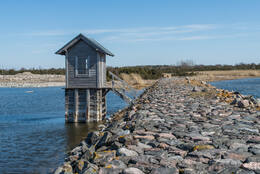
Orjaku harbour was intended to be used as an Imperial Russian Navy base for torpedo boats. Construction began in 1912, only to grind to an indefinite halt following the outbreak of World War I. Just two breakwaters had been completed by this point, which encompass the harbour to this day. During the final years before the Soviet occupation, a channel 4 metres deep, 35 metres wide and 2.2 km long was dredged.
Ristna Lighthouse
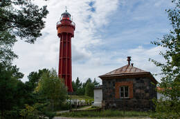
This 30-metre, cast-iron lighthouse was assembled in 1874 from components manufactured in France. The lighthouse was badly damaged during World War I and was reinforced with a concrete outer structure in 1921.
The lighthouse itself is 29.5 metres high, while its light towers 37 metres above sea level. The light can be seen from 31.5 km away.
The lighthouse was also tasked with warning vessels about the ice conditions in the Baltic Sea, alerting them with a blinking red light if the nautical channels were blocked by ice.
This lighthouse is connected to events of the First World War: On 12 August 1914 at 4 AM the German cruiser Magdeburg fired at the Ristna lighthouse and the communications outpost on Cape Ristna. This marked the arrival of the First World War on Estonian territory. Ristna lighthouse was used for communication between patrolling British and Russian submarines and the naval base in Tallinn. Radio communication was avoided. The submarines surfaced at the agreed-upon location and sent their communication officers to the base by the lighthouse to make contact with Tallinn on the phone to receive further instructions. On the same day the Russian Navy used a fairly rare contraption of that time, a hydrophone, to record any noise generated by ship propellers on Cape Ristna. The coastal outpost and cables were destroyed while the Russians retreated, the remains of the hydrophone are still deep on the sea floor to this day, its location unknown. It is worth mentioning that the fog siren building erected in the early 20th century is one of the few surviving fog siren buildings of Estonian lighthouses.
The 130-mm Coastal Battery at Tahkuna No 26
The 130-mm battery at Tahkuna is architecturally similar to the battery at Tohvri. The ferroconcrete surfaces in the gun emplacements bear the inscripted date 20/IV 1941. In 1941 the battery had four 130-mm B-13 guns (weight of gun including shield 12.8 tons, crew 11, shooting range up to 25 km). The crew included 151 seamen and 9 officers. The guns were installed right before the battles of October 1941.
The ferroconcrete gun blocks remained intact in the war and the crew arrived as early as October 1944. First the battery had three 130-mm B-13 guns. The last shots were fired in Tahkuna in January 1960 when there were 4 guns. When the battery was operating, the last kilometre of the road leading to the lighthouse was closed by a barrier and a gate house and this part of the road is still missing on the military topograhic map published in 1959.
The buildings of Tahkuna battery have survived in a fairly good state. In the ammunition depots next to the gun blocks occasional shell shelves have survived, they can also be found in the ammunition depots in the rear of the emplacements. The shelter-power station (the gas shelter) still has bunk beds. Between the boiler house and the diesel power station there is a particular water line hidden in a high parapet with a concrete reservoir at both ends. A fire control tower was built next to the command post in the 1950s and after the battery was closed down, it was used as an observation post of the naval radio technology unit. As the forest kept growing and the seaview got worse, the tower gained another floor. This new addition demonstrates a notably poorer building quality in comparison with the rest. The added floor includes a stove, whereas originally the tower had central heating. On the whole territory of the battery there are cable ditches that have been dug open – dating from the 1960s when the collective farms were permitted to take electric gear from the abandoned batteries, as well as from the early 1990s when all the cables that had been meanwhile installed and could be spotted, were taken. With the territory being completely neglected and heavily overgrown, finding and studying the objects could be complicated.
On the territory of the battery, next to the parking lot, there is a monument from 1968 in memory of the Baltic Navy soldiers who perished in 1941. The author of the monument is Vitali Navoznyhh, originally from Leningrad. He participated in the battles of 1941 in Hiiumaa and settled on the island after the war, working as a stonecarver. Next to the monument there is a tombstone to two unknown soldiers who were buried there in 1973.
Monument to fallen World War II soldiers of Hiiumaa
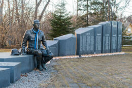
The idea for this memorial came from Otto Mägi, who was assisted in realising it by his comrade Heino Kerde. In 2001, Mägi petitioned Kärdla City Council for a monument to be erected in memory of Hiiumaa's fallen World War II soldiers. The monument was designed by sculptor Elo Liiv and architects Maris Kerge and Kadri Kerge. The model for the sculpture was Marek Vainumäe from Kärdla.
In total, 685 names are engraved in the granite, all of them Hiiumaa’s fallen, regardless of whose uniform they wore. The uniform on the bronze sculpture, on the other hand, is instantly recognisable – the young man is wearing an Estonian uniform and has taken off his German helmet. This is the only monument in Estonia dedicated to all those who fell during the war, not limited to one side. The project came to fruition thanks to government grants from the Ministry of Culture and the Ministry of Defence and donations from private individuals and companies. Construction work was coordinated by Kärdla City Council and the Union of Freedom Fighters and the Repressed of Hiiumaa. The monument was unveiled on 25 May 2012.


