Kuržemės pakrantė – uždara zona


Šaltojo karo metu visa Kuržemės pakrantė buvo uždara zona visuomenei – čia pagrindinius sprendimus priėmė sovietų pasieniečiai, turintys sargybos postus tam tikru atstumu ir stebėjimo bokštus su prožektoriais paplūdimyje. Civiliai asmenys pajūryje buvo leidžiami tik dienos šviesoje.
Pasienio apsaugos pareigūnams buvo pavesta atidžiai stebėti pakrantę, kad niekas negalėtų išvykti iš Kuržemės ar slapta į ją patekti – todėl kiekvieną vakarą paplūdimys daugelyje vietų buvo suartas maždaug 6 metrų pločio juosta, kuri leido nustatyti tokius atvejus. Jei paplūdimyje buvo pastebėta kas nors įtartino, ten nuvykdavo pasienio apsaugos patrulis lengvu visureigiu, o specialiai apmokytas šuo padėdavo rasti pėdsakus. Jei jūroje buvo pastebėta kas nors įtartino, iš nedidelio pastato šalia bokšto buvo išstumtas prožektorius, kurį įjungus, galėjo būti apšviečiamas objektas, esantis iki 22–25 km atstumu. Ne visose vietose buvo tokie švyturiai – pasienio apsaugos pareigūnai naudojo švyturėlius sunkvežimio dėžėje.

Susijusi laiko juosta
Susijusios vietos
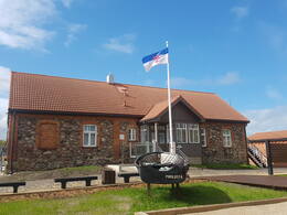
Mazirbės pasienio apsaugos bokštas
Sovietinis pasienio apsaugos postas buvo įsikūręs pastate, kuriame anksčiau buvo jūreivystės mokykla, o šalia jo yra gerai išsilaikęs sovietinis pasienio sargybos bokštas. Antrasis sargybos bokštas yra tiesiai ant kranto, šalia automobilių stovėjimo aikštelės. Šie sargybos bokštai primena sovietų okupaciją ir laikus, kai Mazirbė buvo uždara pasienio zona, o civiliai gyventojai krante buvo leidžiami tik specialiai tam skirtose vietose ir tik dienos metu. Šis pasienio sargybos bokštas yra vienas geriausiai išsilaikiusių tokio tipo objektų Latvijos pakrantėje. Tačiau į jį lipti pavojinga.
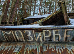
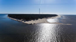
Mazirbės laivų kapinės
Mazirbė, istoriškai vadinama didžiausiu lyvių centru, žymi tuo, kad čia yra vienintelės žvejų laivų kapinės Latvijos pakrantėje. Jos buvo įkurtos septintajame dešimtmetyje, o paskutinės valtys buvo atgabentos 1976 m. Valtys čia atsidūrė tiek dėl žvejybos apribojimų, tiek dėl jų amžiaus.
Šiandien Mazirbėje yra mažiau nei dešimt žvejybinių laivų nuolaužų, tačiau istoriškai jų buvo daug daugiau. Laivai buvo palaidoti ir kituose pajūrio kaimuose, tačiau būtent Mazirbės laivų kapinėse tai šiandien labiausiai akivaizdu.
Mazirbės laivų kapinės yra vienintelės tokio pobūdžio Latvijos pajūryje.
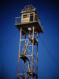
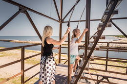
Buvęs sovietinės pasienio apsaugos stebėjimo bokštas Paviluostoje
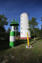
Sovietinis pasienio apsaugos apžvalgos bokštas yra netoli Pietinio molo Paviluostoje. Buvęs sovietinis pasienio apsaugos apžvalgos bokštas, kuris buvo nenaudojamas nuo XX a. dešimtojo dešimtmečio pradžios, dabar tarnauja kaip apžvalgos aikštelė su 360 laipsnių kampu besisukančiu sausumos teleskopu. Iš jo atsiveria gražūs jūros ir laivų vaizdai, jį galima naudoti paukščių stebėjimui. Lipti į bokštą leidžiama tik vasaros sezonu dienos šviesoje. Kadangi bokšto laiptai yra gana statūs, lankytojai turėtų įvertinti savo sugebėjimus, sveikatą ir susijusią riziką. Apžvalgos bokštas ir apylinkės stebimos vaizdo kameromis. Žiemos sezonu bokštas lankytojams uždarytas.
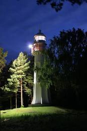
Mērsrago švyturys ir buvęs pasienio sargybinis
Mērsrago švyturys yra Mērsrago kaime, apie 1 km į šiaurę nuo kaimo centro. Švyturys buvo pradėtas eksploatuoti 1875 m. Tai 18,5 m aukščio laisvai stovintis, cilindro formos, kniedėmis sutvirtintas geležinis bokštas, kurio apatinė dalis sustiprinta gelžbetoniniais kontraforsais. Signalinio žibinto aukštis – 21,3 m. Viršuje aplink bokštą yra geležinis balkonas, paremtas konsolėmis. Švyturio bokštą pagamino „Sotera, Lemonier & Co“ Paryžiuje, todėl šis švyturys dažnai vadinamas „prancūziškuoju“. 1944 m. pabaigoje šalia švyturio buvo dislokuota Vokietijos armijos 1003-ioji artilerijos divizijos baterija su 60 cm prožektoriais. 1945 m. gegužę nacistinės Vokietijos vyriausioji vadovybė planavo perkelti į šią vietovę 15-ąją Latvijos SS grenadierių diviziją, tačiau šie planai žlugo, nes Latvijos kareiviai pasidavė Vakarų sąjungininkams. Netoli Mērsrago švyturio išlikę pastato, kuriame SSRS laikais sovietų pasieniečiai turėjo didelį, ištraukiamą prožektorių jūrai apšviesti, liekanos. Šalia švyturio yra paukščių stebėjimo bokštelis. Ekskursijas reikia užsisakyti iš anksto susisiekus su Mērsrago turizmo informacijos centru.
Oviši švyturys ir sovietinė pasienio apsauga
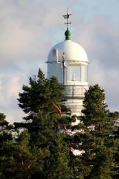
Ovišų švyturys yra Tārgalės valsčiuje, Ovišų kaime, Kuržemės pakrantėje. Jis buvo pastatytas 1814 m. ir yra seniausias švyturys Latvijoje. Ovišų švyturio bokšto aukštis yra 37 m. Švyturys yra dvigubo cilindro konstrukcijos: jo skersmuo yra 11,5 m, tačiau akmeninėje sienoje yra antras bokštas, kurio skersmuo yra 3,5 m. Tokie dvigubo cilindro švyturiai XVIII–XIX a. Europoje taip pat buvo naudojami kaip gynybiniai statiniai priešo atakų atveju. Ovišų švyturio muziejus laikomas didžiausia švyturio įrangos ir jūrų navigacijos daiktų kolekcija tarp visų Latvijos švyturių muziejų. Geru oru iš Ovišų švyturio galima pamatyti Irbės švyturį.
Antrojo pasaulinio karo pabaigoje netoli Ovišų švyturio buvo įsikūręs Vokietijos armijos Bemingerio bataliono štabas kartu su 530-osios jūrų artilerijos divizijos 4-ąja baterija su keliais priešlėktuviniais pabūklais. Pasakojama, kad švyturio papėdėje buvo radijo krypties ieškiklis ir infraraudonųjų spindulių aptikimo stotis „Donau Gerät“. Netoli švyturio kadaise buvo įsikūręs sovietinis pasienio apsaugos postas, tačiau nė vienas sovietmečio pastatas neišliko. Ovišų stoties pastatas vis dar yra švyturio teritorijoje.
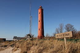
Akmeņrago švyturys ir „Saratovo“ likimas
Akmeņrago švyturys yra Sakos valsčiuje, 10 kilometrų į pietvakarius nuo Paviluostos. Į švyturio viršūnę galima patekti spiraliniais laiptais, iš jos atsiveria vaizdas į jūrą ir aplinkinius miškus. Dabartinis 37 metrų aukščio švyturio bokštas buvo pastatytas 1921 m., o ankstesnis švyturys buvo sunaikintas per Pirmąjį pasaulinį karą.
Akmeņrago švyturys išsiskiria iš kitų Latvijos švyturių, nes yra vienoje pavojingiausių laivybai vietų visoje Baltijos jūros pakrantėje. Švyturio signalinis spindulys žymi uolėtą krantą, kuris šiaurės vakarų kryptimi tęsiasi maždaug dvi jūrmyles arba 3,7 kilometro į jūrą. Kranto gylis yra kiek daugiau nei du metrai. Švyturio vieta nepakito, tačiau pakrantė bėgant metams tolsta. Nors navigacijos šviesa čia yra nuo 1879 m., Akmeņrage įvyko keletas laivų avarijų. Žymiausia įvyko 1923 m. rugsėjį, kai į seklumą atsitrenkė Latvijos garlaivis „Saratow“. 1919 m. Saratovas trumpai buvo Latvijos laikinosios vyriausybės būstinė. Akmeņrage anksčiau buvo pasienio apsaugos postas, čia galima apžiūrėti sovietų armijos pastatus.
Vokietijos armijos pakrančių apsaugos prožektorių aikštelė Ūsyje ir pasienio apsaugos postas Kolkoje
Kolkos kyšulyje nebuvo planuojama jokios karinės infrastruktūros, išskyrus kelis jūrinius švyturius, kurie buvo atstatyti per ilgą laiką – prieš Pirmąjį pasaulinį karą, Pirmojo arba Antrojo pasaulinio karo metu. Siauriausioje Irbės sąsiaurio dalyje, tarp Sirvės pusiasalio ir Mykolo bokšto švyturio, buvo suplanuotos pakrantės gynybos baterijos.
Vieninteliai karinio pobūdžio įtvirtinimai atsirado 1944 m. pabaigoje, kai Vokietijos armijų grupė „Šiaurė“ ruošėsi atremti galimus sovietų Baltijos laivyno išsilaipinimus. 1945 m. pavasarį, ledui atsitraukus, dvi 532-osios artilerijos divizijos baterijos gynė pakrantę ties Kolkos kyšuliu. 7-oji baterija su keturiomis 75 mm patrankomis ir trimis 20 mm zenitinėmis patrankomis. 8-oji baterija su keturiomis 88 mm minosvaidžiais, trimis 20 mm minosvaidžiais ir 81 mm minosvaidžiu. Priešdezertyrinį pėstininkų garnizoną sudarė vienas garsiausių Vokietijos karinio jūrų laivyno pakrantės gynybos dalinių – 531-osios artilerijos divizijos 5-oji kuopa. Nors pavadinimu tai buvo artilerijos dalinys, pagal dislokaciją tai buvo pėstininkų dalinys, kuris savo karą pradėjo 1941 m. birželį prie Liepojos. Tuomet dalinys buvo dislokuotas Suomijos įlankos salose, o vėliau dalyvavo kovose Saremos saloje. Divizijos likučiai buvo pertvarkyti į vieną kuopą ir, sustiprinti septyniais prieštankiniais ir trimis 20 mm priešlėktuviniais pabūklais, dislokuoti Kolkos kyšulyje.
Sovietų jūrų desanto operacija niekada neįvyko, o vokiečių daliniai kapituliavo 1945 m. gegužę.
Karinė infrastruktūra Kolkos kyšulyje pradėta kurti po Antrojo pasaulinio karo, kai čia buvo dislokuoti sovietų pasienio apsaugos postai ir Kolka, kaip ir visa Kuržemės pakrantė nuo Mērsrago iki Lietuvos sienos, tapo uždara zona.
Paviluosto vietos istorijos muziejaus ekspozicija
Paviluostos kraštotyros muziejuje veikianti paroda, pavadinta „Paviluosta, uždara teritorija“, pasakoja apie kasdienį gyvenimą Paviluostos mieste sovietinės okupacijos metu; konkrečiai apie vykdomąją valdžią, pasienio zoną, žvejų kolūkį, kultūrinę ir socialinę veiklą. Be nuolatinės ekspozicijos, yra interaktyvi ir emociškai turtinga skaitmeninė ekspozicija dviem kalbomis bei audiovizualinė instaliacija, kurioje rodomas filmas apie Paviluostą.
Muziejuje taip pat atidaryta nauja paroda pavadinimu „Paviluostos auksiniai smėlio grūdeliai“. Skaitmeninėje instaliacijoje pristatomi seni įvykiai, Paviluostos įkūrimo istorija ir svarbiausi įvykiai nuo 1918 m. iki šių dienų. Karinis paveldas yra pagrindinis Nepriklausomybės karo skyriaus, kuriame pasakojama apie Latvijos laisvės kovotojus ir sovietinės okupacijos laikotarpį, akcentas.