
Гаррисон
I Первая мировая война, I Освободительные войны, II Вторая мировая война, IV Советская оккупация

Гарнизон - это территория, которая может включать одну или несколько прилегающих административных территорий (населенных пунктов), играющих военную, экономическую, культурную или иную роль в деятельности воинских частей.
В ведении начальника гарнизона находится необходимое количество гарнизонных подразделений и их территория.


Связанные объекты
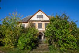
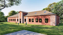
Школа Адама Стил
Здание школы в центре города находится на левой стороне улицы Аусекля, рядом с гимназией Валка Яниса Цимзе.
В здании, названном в честь учителя Адама Стила, первоначально располагалась школа, строительство которого было завершено в 1923 году. В 1946 году здесь располагался военный штаб армейского гарнизона. Таким образом, в центре Валки был создан военный центр, а Валка стала важным объектом ядерного оружия для армии СССР. Территория здания была обнесена высоким забором и называлась городом в городе, потому что здесь был свой магазин, больница, котельная и даже кафе для нужд армии. На кровельной части здания разместили символ советской власти - красную звезду. Армия покинула это место в 20 веке. В конце 80-х, взяв с собой все, что можно было.
Рядом со школой Адама Стила и подземными бункерами находится Шведская (Шереметьевская) крепость. Искусственный земляной вал был построен в начале Северной войны, около 1702 года, для защиты Валки от шведов. Самая крутая стена Скансца обращена к Эргеми, а другая сторона выходит на улицу Аусекля.
Сегодня школа Адама Стила видна только снаружи.
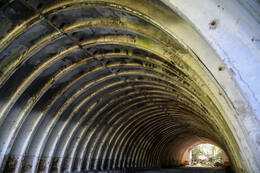
Ракетная база Барта
Паплакский полк. Барта - юг, Барта - север. База разрушена человеком и природой. Здания забраны лесом, грузовики для перевозки ракет и сами ракетные ангары разрушены. Центр связи также был разрушен, а большинство металлических пусковых платформ демонтированы.
Согласно официальной информации, на территории муниципалитета Барта располагались следующие подразделения советской армии:
49028 - 279. Военно-морской передающий центр БКФ
25026, 49393 - 30-е склады корабельных ракет и ядерных боеголовок БКФ
49281 - Управление связи
20480 - 523-е подразделение центра связи
1994 год, покидая Латвию (Последние военнослужащие, покинувшие Латвию, оборудование ракетной базы "Барта", покинули порт Лиепая 31 августа 1994 года.), представленный Северо-Западной группой войск Российской Федерации. В ходе обследования района ракетной базы Барта нами также были обнаружены пусковые площадки баллистической ракеты Р-5М (8К51М) (по классификации НАТО - SS-3 Shyster) с прилегающими к ним командными бункерами. Ракеты Р-5М (8К51М) с ядерными боеголовками были впервые размещены оккупационными войсками в Латвии в 1954 году в Бартаском лесу Лиепайского района. Решением Министерства обороны СССР № 700-330 от 2 июля 1985 года (!) войсковой части № 42341 (50-я ракетная армия в Смоленске, к/д 55135) в Бартском лесу было выделено 2 623 га земли. Там размещены два дивизиона 117-го ракетного полка. Каждый дивизион имеет 4 ракеты. 18 сентября 1959 года армия запрашивает еще 385,25 га для пяти участков в районе Барта-Бриенампурва. Гравий для строительства базы, а также для засыпки и маскировки ангаров был привезен из близлежащего карьера Круте. Фермеров выселяют из домов в Калнаи, Плачени, Пурвичи, Земтуру, Пурву, Книпупью, Мазтуру, Бирзмали в волости Барта. Убытки от ликвидации 8 хозяйств, указанные в архивных документах, составляют всего 154 711 рублей. Все постройки баз вывозились в Барту только ночью, чтобы их никто не видел. Но жители Барты всегда знали: когда армия начнет грейдировать дороги, она будет что-то везти. В 1968 году дивизионы ракет наземного базирования в Барте были расформированы. Модернизированные шахтные ракеты (Р-12 и Р-14) не размещаются в Барте, поскольку она расположена в болотистой местности.
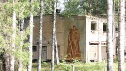
Ракетная база Советской армии в Зелтини (Zeltiņi)
Бывшая ракетная база Советской армии находится в Меднюкалнсе Зелтиньской волости Алуксненского района. С 1961 по 1989 год в Зелтини Алуксненского района действовал особо секретный советский военный объект – база ядерных ракет. Здесь размещались баллистические ракеты средней дальности П-12 (8К63), P12Y (8K63Y) с 4-мя стартовыми площадками. Дальность полета - 2200 км. В этот период армия использовала территорию площадью около 300 га, огороженную колючей проволокой, менее чем в километре от автомобильной дороги регионального значения P34 «Синоле-Силакрогс».
Жилая зона и сверхсекретная зона остались в наследство и сегодня. Бетонные дороги ведут в скрытые в то время места – ангары, стартовые площадки, бомбоубежища. На площади в несколько десятков гектаров расположены различные сооружения, связанные с содержанием и обслуживанием ядерных ракет. Территория была обеспечена автономным электроснабжением, водоснабжением и теплоснабжением, которые были разрушены с уходом армии. После ухода армии часть техники была передана муниципалитету. В настоящее время можно осмотреть 20 га территории бывшей ракетной базы, юго-западная часть которой предлагается как туристическая достопримечательность. Базу можно осмотреть двумя способами – основная экспозиция об истории ракетной базы, которая находится в помещении музея Зелтини, и туристический маршрут по территории базы. На территории базы можно поиграть в лазертаг в компании друзей до 12 человек.
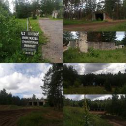
Бывшая ракетная база советской армии "Ракетниеки"
Здания бывшей советской военной базы находятся в запущенном состоянии, но на территории есть автомобильная трасса. Территорию можно исследовать пешком, но для этого необходима хорошая обувь, защищающая от грязи и песка.
Батарея Ольмани №456 (советская военная база "Краснофлотская")
Первые береговые оборонительные батареи для защиты Ирбенского пролива начали строиться после 1912 года, когда был утвержден план минно-артиллерийской оборонительной позиции Балтийского флота, включавший несколько береговых оборонительных батарей и морских минных заграждений.
Позиция в Ирбенском проливе была самой дальней к югу, и ее задачей было блокировать любой доступ противника к Рижскому заливу. Основной упор делался на морские мины, десятки тысяч которых были установлены в Ирбенском проливе во время Первой мировой войны кораблями Балтийского флота. Только в 1916 году на южной оконечности острова Сааремаа, на мысе Сирвес, начали строить береговые оборонительные батареи. Всего было построено семь батарей, а батарея 43 была оснащена 305-мм орудиями. На латвийском побережье Ирбенского пролива оборонительные батареи не строились.
Даже после образования Латвийской Республики латвийская армия и флот не создали артиллерийских позиций для защиты Ирбенского пролива.
Ситуация изменилась после заключения пакта о взаимопомощи между Латвийской Республикой и СССР от 5 октября 1939 года, который предусматривал размещение в Курземе контингента Красной армии и Балтийского военно-морского флота. Советские планы также включали создание системы береговой обороны на основе плана 1912 года с усовершенствованиями. Планировалось построить береговые оборонительные батареи на месте Лиепайской крепости, новые батареи к югу от Вентспилса (батарея № 46) и две батареи в самой узкой части Ирбенского пролива у Микельторниса. Уже после оккупации и аннексии Латвии планы береговой обороны Балтийского флота были дополнены, и к июню 1941 года в северной части Курземе планировалось создать 207-й артиллерийский дивизион с пятью батареями. Две батареи должны были быть установлены в окрестностях Микельторниса - батарея 40 в Лужне со 130-мм орудиями B-13 в железобетонных укреплениях и батарея 117 в Олмани (место, обозначенное на картах латвийской армии как Ķesteri) со 152-мм орудиями MU-2. Поскольку разработка 152-мм орудий не была завершена, на железобетонных укреплениях батареи были построены временные деревянные платформы и установлены еще четыре 130-мм орудия. Строительство обеих батарей было завершено к июню 1941 года, но батареи не удалось отследить в ходе войны против немецкой 291-й пехотной дивизии, и их экипажи переехали на остров Сааремаа.
В конце Второй мировой войны немецкая группа армий "Курляндия" довольно серьезно относилась к возможным советским высадкам в северной Курляндии, особенно после таяния льда в Финском заливе и на западном побережье Эстонии. По всему побережью Курземе были развернуты самодельные батареи береговой обороны. Советская батарея № 40, Gerate Batterie Sommer 289-го артиллерийского дивизиона с двумя 122-мм советскими гаубицами, была размещена на железобетонных позициях у Лужне. В районе позиций батареи № 117 находилась батарея № 2 530-го артиллерийского дивизиона с тремя 152-мм советскими трофейными пушками, тремя 37-мм зенитными установками, одной 20-мм четырехствольной зенитной установкой, двумя 75-мм противотанковыми пушками и двумя минометами для освещения.
После окончания активных боевых действий в мае 1945 года СССР начал восстанавливать систему береговой обороны на Курземском побережье. Осенью 1945 года у дома Ольманского была развернута временная батарея 456 со 152-мм орудиями системы Кане, которая была переименована в "Краснофлотскую".
В 1952 году временные орудия батареи были заменены на новейшие 152-мм орудия системы МУ-2. Батарея состояла из четырех железобетонных орудийных установок, железобетонного командного пункта с дальномерной башней и технических зданий. Строительство батареи было завершено в 1958 году.
В 1958 году, после демонтажа батареи береговой обороны "Лужня", она была заменена мобильной батареей 130-мм орудий SM-4-1 № 343. Мобильные орудия не имели железобетонных орудийных установок, но было построено несколько бревенчатых и песчаных сооружений.
Батарея № 343 действовала до начала 1960-х годов, а батарея № 456 - до 1975 года, когда она была законсервирована. Позиции батареи использовались для размещения зенитно-ракетных комплексов С-125, а также 10-го артиллерийско-ракетного полка береговой обороны с ракетными комплексами КП-2 "Сопка", и инфраструктура была соответствующим образом изменена.
В 1993 году Советская Армия передала инфраструктуру батарей "Олмани" и "Лужна" Латвийской Республике.
Историческая экспозиция Адажского (Ādaži) гарнизона
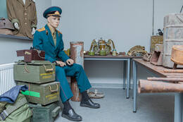
Историческая экспозиция Адажского гарнизона находится в Адажском районе, Кадага, на территории Адажского национального учебного центра. Посетив экспозицию, вы сможете ознакомиться с военной техникой и бытом солдат. Рядом находится крупнейший военный полигон в странах Балтии и уникальная территория для тренировок. История полигона началась в конце 20-х годов 20-го века, он был создан под Ригой, в окрестностях Лиласте. После Первой мировой войны и войны за независимость Латвии в раздираемой войной стране создавалась латвийская армия. Народ Латвии столкнулся с войной и безразличным отношением иностранных армий. За относительно короткое время армия превратилась в многочисленную военную силу большими солдатскими резервами. Полигоны и летние лагеря приблизили повседневную жизнь солдат к условиям войны, позволив им улучшить свои навыки и знания. Железнодорожная ветка Рига-Саулкрасты, построенная в начале 1930-х годов, стала важной для развития полигона Лиласте или Гауя. Она позволяла перевозить боеприпасы и технику, а также служила целям защиты побережья. Во время советской оккупации полигон значительно расширился, символизируя размах милитаризации Советской армии. Гарнизон - набор воинских частей, которые постоянно или временно дислоцируются на определенной административной территории. Полигон - место отработки технических средств и тренировки войск.
Военная база советской армии в Павилосте - центр активного отдыха
В советское время здесь располагалась пограничная часть, в нескольких километрах в лесу находились другие подразделения советской армии - офицеры связи и база зенитных ракет. После обретения независимости здесь разместилась латвийская армия.
Бывшая военная база советской армии теперь является центром отдыха, досуга и кемпинга - для развития личности во взаимодействии с природой и окружающими людьми.
Место для отдыха и проживания как туристических групп, так и семей. Комнаты, душ, туалет, камины, просторная территория для занятий, звуки природы. Бронируйте заранее, позвонив по телефону +371 26314505.
Связанные истории
Мемориальный момент на Гарнизонном кладбище
После восстановления независимости Латвии Улдис Велдре, руководитель отдела Комитета братских кладбищ Алуксне, позаботился о содержании Гарнизонного кладбища, выявлении связанных с ЛКОК мест отдыха, связанных с Алуксне, и установке мемориалов. на Гарнизонном кладбище.