
Pillbox
I World War I, II World War II, IV Soviet Occupation

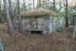
A pillbox (Latvian: dots, derived from an acronym for the Russian term "Дот" Долговременная огневая точка) is a reinforced concrete fortification structure intended for firing various weapons and providing protection from small arms and grenades.
Fortification structures like these have survived in Latvia in particular because they are more resistant (made of reinforced concrete) to natural processes and human activity.
More information sources
https://encyclopedia2.thefreedictionary.com/Log+Pillbox


Related timeline
Related objects
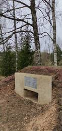
Kundera pillbox
The memorial of the fallen officer of the 8th Estonian Rifle Corps of the Red Army, Jakob Kundera (deleted), is located at the cemetery 200 metres south-west of the Blidene-Remte road and the Riga-Liepaja railway junction.
On 17 March 1945, the last attempt of the Red Army's offensive in Kurzeme began. The task of the 7th Estonian Rifle Division of the Estonian 8th Rifle Corps was to reach the Riga-Liepaja railway line west of Blidene station and to secure the attack of the Mechanised Corps of the 3rd Guards in the direction of Gaiki. By the evening of 17 March, the 354th Rifle Regiment reached the railway south of Kaulači Manor through the forest and continued its attacks in a north-westerly direction. As the attacks of the 130th Latvian Rifle Corps towards Pilsblidene Manor were not so successful, the Estonian 300th Rifle Regiment was tasked to attack westwards and south-westwards on the night of 18 March to cross the railway from the north to capture Blidene station.
In the vicinity of Blīdene station, already in the spring of 1940, the Latvian army had built temporary barracks and warehouses, which were designated as "Barracks". During 1945, the German army built several underground shelters (bunkers) in the vicinity of the station, where soldiers could live during the winter. There were no fortifications, driven or given, and it is most likely that Lieutenant Jakob Kunder fell during close combat at one of the bunkers.
Immediately after the battle, Jakob Kunder was buried in what is now Pilsblidene Cemetery, and later reburied in the Tuški Brethren Cemetery.
Today, a symbolic Soviet reproduction of a reinforced concrete machine-gun embrasure with a commemorative plaque can be seen.
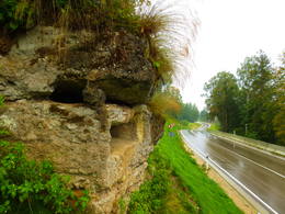
German army concrete fire point on the P 87 road
A concrete fire point of the German army from the First World War, located on the left bank slope of the Daugava, 300 m east of Tambovičiai, near the Bauska - Aizkraukle (P87) road. Two loopholes have survived from the concrete fire point. After the reconstruction of the road, its surroundings (the bank slope) have been cleared of bushes and the object is now clearly visible when driving from the road. The road is narrow and there is no place to park a car near the object! It is difficult to get to the object, as the slope is steep and sometimes slippery. The road offers beautiful views of the Daugava valley.
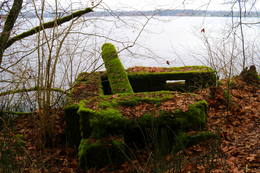
German army concrete fire point on the bank of the Ķegums HPP east of Lejasgrantiņi
It is located about 0.25 km east of the extension of a small stream (the stream flows into Lejasgrantiņi) on the slope of the Ķegums HPP bank. From the Jaunjelgava - Ķegums road (P85) it can be found by walking along the Daugava bank (overgrown, before that – a forest clearing). A careful observer will also notice it from the river, because during the summer there is lush vegetation here. The concrete parts of the fire point are covered with green moss, metal and wooden structures are visible in the opening. Since the fire point is located on the edge of a washed-out bank as a result of the wave action of the Ķegums HPP, it can be dangerous to visit. There is a deep pit (bomb pit?) nearby. This is the eighth (from the Ķegums HPP, towards Jaunjelgava) of the fire points of the German army's World War I defense line on the left bank of the Daugava, which can be traced more or less along the entire length of the left bank of the Daugava. The aforementioned line of defense is a large-scale military system that has not yet been truly evaluated as a unified whole.
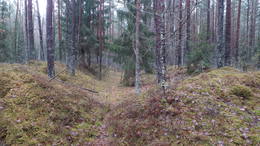
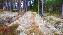
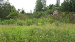
Site of former World War I barracks
Located in a forest 0.6 – 0.7 km south of the village of Latgale. The best idea of the territory can be obtained if it is previously studied on LIDAR maps, because in nature the positions of trenches and other earth surface formations dug by people a century ago can go unnoticed by the uninitiated. Judging by the remains of a brick kiln and other signs visible in the excavations (carried out by someone else), there were barracks of the German army here. Next to the barracks along the Great Kurfirst Dam from the modern Lāčplēsis station along Birzgali and further to the supply of the Daugava front line, a narrow-gauge railway was built. 0.5 km east of the barracks was the so-called Kurland or Mātīte Monument (Kurland Denkmal), but on the left bank of the Daugava, within a radius of 1.3 km around the barracks, three reinforced concrete fire points were built (surviving to this day, but the remains of one are under water and appear only when the water level of the HPP is reduced), while 0.6 km west of them was a shooting range, of which nothing has survived in nature. Around the shooting range, pits are visible in nature – the remains of former buildings and fortifications. About 100–200 m southeast of the former barracks site, three to 30 m long, rectangular trenches (and smaller ones) are clearly visible in nature, which may have been warehouses.
Narrow gauge railway line during World War I: Lāčplēsis – Latgale
The approximately 22 km long narrow gauge railway line of the First World War, which began at the current Lāčplēsis (Jelgava – Krustpils railway line) railway station (former Bahnhoff Kerghof), skirted Birzgali from the east, crossed the Žega River, then turned west, crossing the modern Abermaņa Road twice (connecting Ķeguma with the Vecumnieki (P88) road) and then along the Ķeizardambi (Kaiser – Damm) to the former Kurland Monument (Kurland Denkmal), where, judging by the LIDAR map visible (divided into three branches?), the final station was located. The Kurland Monument was located 680 m southeast of the Latgali village. The main purpose of the railway was to provide and support the front on the left bank of the Daugava with the necessary. During the First World War, there were German army barracks and warehouses near the Ķeizerdambs, and on the left bank of the Daugava near Puduri (0.6 km) and Podnieki (0.9 km), there were three German army concrete fire points. Today, the location of the railway line can be traced using LIDAR maps in nature. Some parts of it are also clearly visible in nature, especially when vegetation has not grown. The best time to go on an expedition is early spring or winter, when there is no snow.
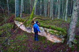
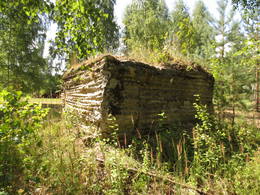
Fragment of World War I fortifications near the Lesmani brothers' cemetery
If you go west from the Dzintari – Vecumnieki road (P88) to the cemetery of the Lezmans (Lesmaņu, Lessmann) brothers, behind the stream that you have to cross, there are very interesting remains of a World War I fortification with a bunker and a fragment of a concrete wall. Judging by the remains of bunkers, trench positions and pits visible in nature and on LIDAR maps in a wider area – all the way to the Daugava, there was a larger military “complex” here in the relevant period with buildings, warehouses, defensive structures, etc. Approximately a kilometer north of this place, on the banks of the Daugava there is a concrete fire point of the German army.
German army concrete fire point on the banks of the Ķegums HPP near Pludinātijai
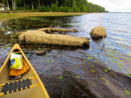
Located on a peninsula between Pludinātijai and the village of Latgali. As a result of wave erosion, the object has slipped from the shore slope to the current water level of the river. When the water level in the Ķegums HPP reservoir is higher, it is washed by the waters of the Daugava. When the water level is lower, it is completely dry. This is one of the fire points of the German army's World War I defense line on the left bank of the Daugava, which can be more or less traced along the entire length of the left bank of the Daugava. The aforementioned defense line is a large-scale military system that has not yet been fully evaluated as a single entity. The fire point can be seen well by taking a boat ride along the Ķegums HPP. The other option is to walk along a small path along the Daugava bank, which leads from the well-maintained beach “Spārītes”.
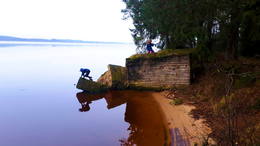
German army concrete fire point on the banks of the Ķegums HPP near Puduri
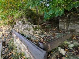
Located on a peninsula at the mouth of the Konupīte River (now a flooded extension of the river) in the Daugava, in the territory of the Puduri recreation complex. As a result of wave erosion, the fire point has tilted towards the river. To prevent erosion of the banks, the banks of the reservoir are reinforced with a concrete protective wall. The fire points of the German army's defense line during the First World War can be traced more or less along the entire length of the left bank of the Daugava. The aforementioned defense line is a large-scale military system that has not yet been properly evaluated as a single entity. The fire point can be seen well when taking a boat trip along the Ķegums HPP.
Remains of a German army concrete fire point at the Kegums HPP reservoir near Podnieki
Located in the Ķegums HPP reservoir, in a small bay, about 20-30 m from the Daugava bank opposite the Podnieki house. The outline of the fire point appears only when the water level in the Ķegums HPP reservoir is low. The rest of the time, they are under water and not visible. This is the third (from the Ķegums HPP, towards Jaunjelgava) of the fire points of the German army's defense line on the left bank of the Daugava during the First World War, which can be more or less traced along the entire length of the left bank of the Daugava. The aforementioned defense line is a large-scale military system that has not yet been fully evaluated as a single entity. The remains of the fire point can be viewed at low water level while taking a boat trip along the Ķegums HPP.
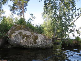
Remains of a German army concrete fire point on the shore of the Ķegums HPP reservoir opposite Silapūpėžys
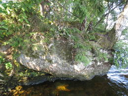
Located about 0.1 km east of the Ķegums HPP reservoir bay near Silapūpēži, towards Jaunjelgava. The fire point has partially sunk into the water, overgrown with trees, bushes and other vegetation, and to the uninitiated, from a greater distance from the water side, it may resemble a larger stone. One of the landmarks is a birch tree growing on it. This is one of the fire points of the German army's World War I defense line on the left bank of the Daugava, which can be more or less traced along the entire length of the left bank of the Daugava. The aforementioned defense line is a large-scale military system that has not yet been fully evaluated as a single entity. The remains of the fire point can be viewed by boating along the Ķegums HPP. About 150 m east of the Daugava bank, the remains of another fire point have sunk into the water.
Remains of a German army concrete fire point in the Ķegums HPP reservoir opposite Sidrabiņi
Located about 0.25 km east of the Ķegums HPP reservoir bay near Silapūpēži, towards Jaunjelgava, opposite the Sidrabiņi farm. The fire point has partially sunk into the water and broken into several parts, resembling a pile of construction debris. The bank is overgrown. This is one of the fire points of the German army's World War I defense line on the left bank of the Daugava, which can be more or less traced along the entire length of the left bank of the Daugava. The aforementioned defense line is a large-scale military system that has not yet been fully evaluated as a single entity. The remains of the fire point can be viewed by boating along the Ķegums HPP. About 150 m west of the Daugava bank, the remains of another fire point have sunk into the water.
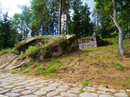
German army concrete fire point at the Ķegums HPP reservoir at the mouth of the Žega River
Located in the Ķegums HPP reservoir at the mouth of the Žegums River (opposite the Žegums House), on its left bank. One of the most visually and scenically impressive and also better preserved concrete fire points washed by the waves of the Daugava. It can be seen from a greater distance. A footbridge has been built from the shore to the top of the fire point (overgrown with grass). Narrow-gauge railway (?) tracks are built into the concrete walls of the fire point. You can enter it from the footbridge. This is one of the fire points of the German army's World War I defense line on the left bank of the Daugava, which can be more or less traced along the entire length of the left bank of the Daugava. The aforementioned defense line is a large-scale military system that has not yet been truly evaluated as a single entity. The remains of the fire point can be viewed by boating along the Ķegums HPP.
Remains of a German army concrete fire point at the Kegums HPP reservoir opposite Jaundauguļi
Located on the shore of the Ķegums HPP reservoir, about 0.6 km east of the Žega mouth, opposite Jaundauguļi. The fire point has slipped from the shore into the water and split into several parts. Two larger birches have grown into it, and a thicket has grown. One part of it is connected to the shore by a footbridge. This is one of the fire points of the German army's World War I defense line on the left bank of the Daugava, which can be more or less traced along the entire length of the left bank of the Daugava. The aforementioned defense line is a large-scale military system that has not yet been fully evaluated as a single entity. The remains of the fire point can be viewed by boating along the Ķegums HPP.
German army concrete fire point on the upper bank of the Ķegums HPP opposite Anduli
It is located about 1.2 km east of a small stream widening (the stream flows into Lejasgrantiņi) at the top of the steep bank slope of the Ķegums HPP opposite Anduļi. The bank in this place is overgrown with forest and undergrowth, so only a keen observer will notice this fire point from the side of the reservoir. The fire point is well preserved, as it has not been damaged by bank erosion. This is one of the fire points of the German army's World War I defense line on the left bank of the Daugava River, which can be more or less traced along the entire length of the left bank of the Daugava River. The aforementioned defense line is a large-scale military system that has not yet been properly evaluated as a single entity. The fire point can be viewed by boating along the Ķegums HPP, as it is located on private territory.
World War I battlefields
During the First World War, the so-called "Life and Death" front line was located in Daugavpils region for several years, where a complex system of fortifications was built. To this day, countless concrete bunkers, gun and ammunition depots, trenches, and graves of soldiers fighting on both sides of the front have survived in the forests of Svente and Medumi parishes.
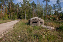
Concrete bunker firing point near Gauja willage
Located in Inčukalns municipality, on the side of the road near the village of Gauja, near the junction of the A2 and A3 highways.
The fortification is a very rare and valuable example of fortification. The structure was designed for one person to observe an important traffic junction. To the NW is a bridge over the Gauja, to the E - a crossing over the Inčupīte, to the SW - a road junction and to the S - one of the main traffic routes - the Vidzeme highway. The reinforced concrete fortification was part of the surrounding trenches, the exact time of construction of which is unknown. Most likely, it was built by the German army during World War II. The site requires further research to clarify the information.
At the end of the 19th century, the area around Inčukalns Manor developed into an important traffic hub. During World War I, the area gained the importance of a defensive area, where possible hostilities were planned. Fortifications were built near traffic routes, the Inčukalns railway station and the Gauja River crossing. The area retained its strategic importance in subsequent wars.
Today, you can view the fortification, which is freely accessible.
The Defence Line with 21 Machine Gun Bunkers (Sarve-Lehtma)
Ferroconcrete machine gun bunkers were built in 1941. The word used in Estonian Dott – is an Estonian adaptation of a Soviet Army term ДОТ (долговременная огневая точка), literally translated as a point of constant firing. It is a closed defensive structure made of stone, concrete, armoured tiles etc.
Sarve-Lehtma defence line never saw much military action, as the enemy arrived from an unexpected direction. The defence line had been built on the eastern and northern coasts of Hiiumaa but the German landing arrived on the southern coast in October 1941. Sarve-Lehtma defence line machine gun bunkers are the same type of heavy machine gun positions for 2-3 gunners. Some minor differences occur (number of embrasures, shape and location of anterooms etc.). These structures were completed in haste, using available materials under the conditions of war, hence the quality of construction varies.
Today, the bunkers have hardly any function. In Heltermaa one of the bunkers is used as a cellar, on the Cape of Sääre it is used as a base of an RMK (State Forest Management Centre) viewing platform. The condition of ferroconcrete is satisfactory, metal shutters and doors of embrasures are missing. Some of the bunkers are situated in the woods so badly overgrown that they are impossible to spot.
There are nearly 50 machine gun bunkers in Hiiumaa but they form a steady long defence line only here. Most of them are located around coastal batteries. In 1970 the border guards installed three SPS-3 machine gun bunkers made of precast ferroconcrete panels, one of them (from Suursadama Position) has been dispatched to Hiiumaa Military Museum.
First World War Museum
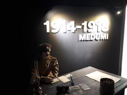
The fiercest battles of the First World War in Latvia took place near Daugavpils in August and October 1915, in the highlands of Ilūkste and Medumi. The Germans tried to break through to Daugavpils, but the Russians – to push them back. Both sides were unsuccessful and began to build trenches, creating in depth defence positions consisting of three lines.
The First World War Museum in Medumi is dedicated to these battles. The first part of the exhibition presents the history of the vicinity of Medumi, providing testimonies that bear evidence that Medumi was a well-populated and developed area before the war. Part 2 focuses on the events of the First World War in Europe and Latvia. Here, you can learn about the lives of soldiers and the innovations that emerged during the war, as well as examine the weapons used by the German and Russian armies. In the third hall of the exhibition, visitors can put themselves in the shoes of a soldier by experiencing bunker life. In this hall, a replica of a Russian bunker has been created – a fragment of a trench with a small shelter, elements of a battlefield and dummies of soldiers. Since the wooden bunkers of the Russian Army did not survive, they have been reconstructed at the museum, while the concrete bunkers of the German Army can be seen by visiting the International route of WWI Bunkers. The hall, with the imitation of a shelter, audio and video equipment, creates an authentic atmosphere of the battlefield.
Remains of a German army concrete firing point on an island in the Pļaviņa HPP reservoir
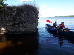
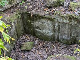
Located on a small island (about 0.2 km long) in the Pļaviņas HPP reservoir, which is located close to the coast, opposite Baloži and Jāņa Kūpinātava. The island was created by forming the Pļaviņas reservoir and raising the water level, because before that it was part of the Daugava valley coast. The island is covered with a forest with thick undergrowth, where it is difficult to move. The fire point (suffered from shelling? blown up?) has only two well-preserved walls. It does not have a roof part.
The firing points of the German army's defensive line during World War I can be traced more or less along the entire length of the left bank of the Daugava from Ķegums to the Pļaviņas HPP reservoir, inclusive. The aforementioned defensive line is a large-scale military system that has not yet been truly evaluated as a unified whole.
The fire point can be seen well from a boat. It will be more difficult to find from the shore.
Remains of a German army concrete fire point on the banks of the Plavinas HPP
Located in the head of a small bay of the Pļaviņas HPP reservoir between Bitānes and Baloži, approximately opposite the Čoči cemetery. The fire point is perfectly camouflaged on a small dolomite rock ridge, merging with the surrounding landscape, over which the foliage of trees bends, so it is difficult for an uninitiated person to notice it. The remains of the fire point are located close to the water level (when it is not lowered in the reservoir) and can be recognized by the metal rods with which the contour of the structure was reinforced. The waves of the reservoir have severely eroded the shore.
The firing points of the German army's defensive line during World War I can be traced more or less along the entire length of the left bank of the Daugava from Ķegums to the Pļaviņas HPP reservoir, inclusive. The aforementioned defensive line is a large-scale military system that has not yet been truly evaluated as a unified whole.
The fire point can be seen well from a boat. It will be more difficult to find from the shore.
German army concrete fire point on the banks of the Riga HPP near Kausupīte inlet No. 1
Located on the left bank of the Daugava River, about 350 m from the mouth of the Kausupīte River, towards the west. Completely submerged. The object can only be reached by boat. It is possible that it can be approached closer when the water level at the Riga HPP is lowered. This is one of the firing points of the German army's defense line on the left bank of the Daugava River during the First World War, which can be more or less traced along the entire length of the left bank of the Daugava River. The aforementioned defense line is a large-scale military system that has not yet been fully evaluated as a single entity.

German army concrete fire point on the banks of the Riga HPP near Kausupīte inlet No. 3
Located at the Riga HPP, on the left bank of the Daugava, about 70 m from the mouth of the Kausupīte, towards the east. Located on the very shore of the HPP reservoir (partly washed by water). Easily visible from the river. Scenic. This is one of the firing points of the German army's defense line on the left bank of the Daugava during the First World War, which can be more or less traced along the entire length of the left bank of the Daugava. The aforementioned defense line is a large-scale military system that has not yet been properly evaluated as a single entity.

German army concrete fire point on the bank of Riga HPP near Kausupīte inlet No. 4
Located at the Riga HPP, on the left bank of the Daugava, about 400 m from the mouth of the Kausupīte, towards the east (behind the Berkava cemetery). Located on the very shore of the HPP reservoir (partly washed by water). Easily visible from the river side, but an uninitiated person can confuse it with larger stones or dolomite blocks. This is one of the firing points of the German army's defense line on the left bank of the Daugava during the First World War, which can be more or less traced along the entire length of the left bank of the Daugava. The aforementioned defense line is a large-scale military system that has not yet been fully evaluated as a single entity.


German army concrete fire point on the banks of the Riga HPP at Kausupīte inlet No. 2
Located at the Riga HPP, on the left bank of the Daugava, about 150 m from the mouth of the Kausupīte, towards the west. Completely submerged. The object can only be reached by boat. It is possible that it can be approached closer when the water level at the Riga HPP is lowered. This is one of the fire points of the German army's World War I defense line on the left bank of the Daugava, which can be more or less traced along the entire length of the left bank of the Daugava. The aforementioned defense line is a large-scale military system that has not yet been properly assessed as a single entity. 200 m west of this, in the Daugava water, there are ruins of a similar fire point.

Related stories
Coastal battery at Olmaņi
North of Ventspils there is another important coastal battery. It was located in Olmaņi and was called "Krasnoflotskaya".
“PZ" - border zone
Memories of Andris Zaļkalns, chairman of the Vērgale village council of people's deputies (1982-1989), about life in the border zone.
The feat of Hero of the Soviet Union - Lieutenant Jakob Kunder of the 8th Estonian Corps
The heroic actions of fallen officer Jakob Kunder of the 8th Estonian Rifle Corps of the Red Army ensured the successful assault of the battalion, but he himself was killed, and a monument has been dedicated to Jakob Kunder at the site of his fall and a monument has been erected at the Tuškis Brothers Cemetery.